

the earth observation handbook
The Earth Observation Handbook - Key Tables - SEOCA
The Earth Observation Handbook - Key Tables - SEOCA
- No tags were found...

You also want an ePaper? Increase the reach of your titles
YUMPU automatically turns print PDFs into web optimized ePapers that Google loves.
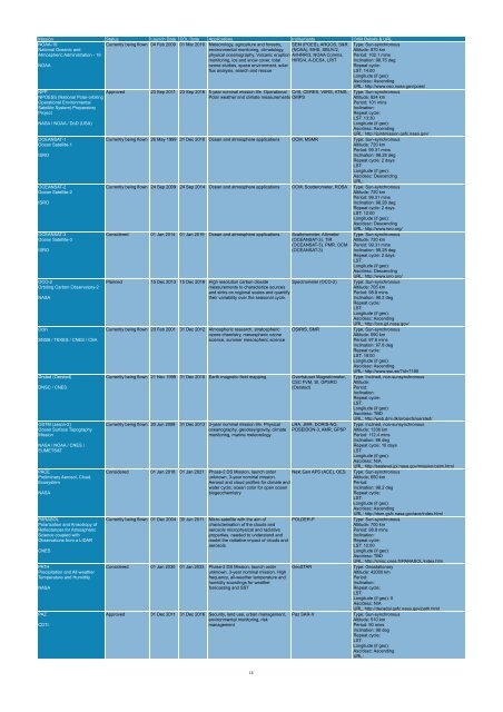
Mission Status Launch Date EOL Date Applications Instruments Orbit Details & URL<br />
NOAA-19<br />
National Oceanic and<br />
Currently being flown 04 Feb 2009 01 Mar 2016 Meteorology, agriculture and forestry,<br />
environmental monitoring, climatology,<br />
SEM (POES), ARGOS, S&R<br />
(NOAA), MHS, SBUV/2,<br />
Type: Sun-synchronous<br />
Altitude: 870 km<br />
Atmospheric Administration - 19<br />
physical oceanography, Volcanic eruption AVHRR/3, NOAA Comms, Period: 102.1 mins<br />
monitoring, ice and snow cover, total HIRS/4, A-DCS4, LRIT Inclination: 98.75 deg<br />
NOAA<br />
ozone studies, space environment, solar<br />
flux analysis, search and rescue<br />
Repeat cycle:<br />
LST: 14:00<br />
Longitude (if geo):<br />
Asc/desc: Ascending<br />
URL: http://www.oso.noaa.gov/poes/<br />
NPP<br />
NPOESS (National Polar-orbiting<br />
Operational Environmental<br />
Satellite System) Preparatory<br />
Project<br />
NASA / NOAA / DoD (USA)<br />
OCEANSAT-1<br />
Ocean Satellite-1<br />
ISRO<br />
OCEANSAT-2<br />
Ocean Satellite-2<br />
ISRO<br />
OCEANSAT-3<br />
Ocean Satellite-3<br />
ISRO<br />
OCO-2<br />
Orbiting Carbon Observatory-2<br />
NASA<br />
Odin<br />
SNSB / TEKES / CNES / CSA<br />
Ørsted (Oersted)<br />
DNSC / CNES<br />
OSTM (Jason-2)<br />
Ocean Surface Topography<br />
Mission<br />
NASA / NOAA / CNES /<br />
EUMETSAT<br />
PACE<br />
Preliminary Aerosol, Cloud,<br />
Ecosystem<br />
NASA<br />
PARASOL<br />
Polarization and Anisotropy of<br />
Reflectances for Atmospheric<br />
Science coupled with<br />
Observations from a LIDAR<br />
CNES<br />
PATH<br />
Precipitation and All-wea<strong>the</strong>r<br />
Temperature and Humidity<br />
NASA<br />
PAZ<br />
CDTI<br />
Approved 23 Sep 2011 23 Sep 2016 5-year nominal mission life. Operational CrIS, CERES, VIIRS, ATMS,<br />
Polar wea<strong>the</strong>r and climate measurements OMPS<br />
Type: Sun-synchronous<br />
Altitude: 824 km<br />
Period: 101 mins<br />
Inclination:<br />
Repeat cycle:<br />
LST: 13:30<br />
Longitude (if geo):<br />
Asc/desc: Ascending<br />
URL: http://jointmission.gsfc.nasa.gov/<br />
Currently being flown 26 May 1999 31 Dec 2010 Ocean and atmosphere applications OCM, MSMR Type: Sun-synchronous<br />
Altitude: 720 km<br />
Period: 99.31 mins<br />
Inclination: 98.28 deg<br />
Repeat cycle: 2 days<br />
LST:<br />
Longitude (if geo):<br />
Asc/desc: Descending<br />
URL:<br />
Currently being flown 24 Sep 2009 24 Sep 2014 Ocean and atmosphere applications OCM, Scatterometer, ROSA Type: Sun-synchronous<br />
Altitude: 720 km<br />
Period: 99.31 mins<br />
Inclination: 98.28 deg<br />
Repeat cycle: 2 days<br />
LST: 12:00<br />
Longitude (if geo):<br />
Asc/desc: Descending<br />
URL: http://www.isro.org/<br />
Considered 01 Jan 2014 01 Jan 2019 Ocean and atmosphere applications Scatterometer, Altimeter<br />
(OCEANSAT-3), TIR<br />
(OCEANSAT-3), PMR, OCM<br />
(OCEANSAT-3)<br />
Planned 15 Dec 2013 15 Dec 2016 High resolution carbon dioxide<br />
measurements to characterize sources<br />
and sinks on regional scales and quantify<br />
<strong>the</strong>ir variability over <strong>the</strong> seasonal cycle.<br />
Spectrometer (OCO-2)<br />
Currently being flown 20 Feb 2001 31 Dec 2012 Atmospheric research, stratospheric<br />
ozone chemistry, mesospheric ozone<br />
science, summer mesospheric science<br />
OSIRIS, SMR<br />
Currently being flown 21 Nov 1999 31 Dec 2010 Earth magnetic field mapping Overhauser Magnetometer,<br />
CSC FVM, SI, GPSRO<br />
(Oersted)<br />
Currently being flown 20 Jun 2008 31 Dec 2013 3-year nominal mission life. Physical<br />
oceanography, geodesy/gravity, climate<br />
monitoring, marine meteorology<br />
LRA, JMR, DORIS-NG,<br />
POSEIDON-3, AMR, GPSP<br />
Considered 01 Jan 2018 01 Jan 2021 Phase-2 DS Mission, launch order<br />
unknown, 3-year nominal mission.<br />
Aerosol and cloud profiles for climate and<br />
water cycle; ocean color for open ocean<br />
biogeochemistry<br />
Next Gen APS (ACE), OES<br />
Currently being flown 01 Dec 2004 30 Jun 2011 Micro-satellite with <strong>the</strong> aim of<br />
characterisation of <strong>the</strong> clouds and<br />
aerosols microphysical and radiative<br />
properties, needed to understand and<br />
model <strong>the</strong> radiative impact of clouds and<br />
aerosols.<br />
Considered 01 Jan 2030 01 Jan 2033 Phase-2 DS Mission, launch order<br />
unknown, 3-year nominal mission. High<br />
frequency, all-wea<strong>the</strong>r temperature and<br />
humidity soundings for wea<strong>the</strong>r<br />
forecasting and SST<br />
Approved 31 Dec 2011 31 Dec 2016 Security, land use, urban management,<br />
environmental monitoring, risk<br />
management<br />
POLDER-P<br />
GeoSTAR<br />
Paz SAR-X<br />
Type: Sun-synchronous<br />
Altitude: 720 km<br />
Period: 99.31 mins<br />
Inclination: 98.28 deg<br />
Repeat cycle: 2 days<br />
LST:<br />
Longitude (if geo):<br />
Asc/desc: Descending<br />
URL: http://www.isro.org/<br />
Type: Sun-synchronous<br />
Altitude: 705 km<br />
Period: 98.8 mins<br />
Inclination: 98.2 deg<br />
Repeat cycle:<br />
LST:<br />
Longitude (if geo):<br />
Asc/desc: Ascending<br />
URL: http://oco.jpl.nasa.gov/<br />
Type: Sun-synchronous<br />
Altitude: 590 km<br />
Period: 97.6 mins<br />
Inclination: 97.8 deg<br />
Repeat cycle:<br />
LST: 18:00<br />
Longitude (if geo):<br />
Asc/desc: Ascending<br />
URL: http://www.ssc.se/?id=7180<br />
Type: Inclined, non-sunsynchronous<br />
Altitude:<br />
Period:<br />
Inclination:<br />
Repeat cycle:<br />
LST:<br />
Longitude (if geo):<br />
Asc/desc: TBD<br />
URL: http://web.dmi.dk/projects/oersted/<br />
Type: Inclined, non-sunsynchronous<br />
Altitude: 1336 km<br />
Period: 112.4 mins<br />
Inclination: 66 deg<br />
Repeat cycle: 10 days<br />
LST:<br />
Longitude (if geo):<br />
Asc/desc: N/A<br />
URL: http://sealevel.jpl.nasa.gov/mission/ostm.html<br />
Type: Sun-synchronous<br />
Altitude: 650 km<br />
Period:<br />
Inclination: 98.2 deg<br />
Repeat cycle:<br />
LST:<br />
Longitude (if geo):<br />
Asc/desc: Ascending<br />
URL: http://dsm.gsfc.nasa.gov/ace/index.html<br />
Type: Sun-synchronous<br />
Altitude: 700 km<br />
Period: 98.8 mins<br />
Inclination:<br />
Repeat cycle:<br />
LST: 12:00<br />
Longitude (if geo):<br />
Asc/desc: TBD<br />
URL: http://smsc.cnes.fr/PARASOL/index.htm<br />
Type: Geostationary<br />
Altitude: 42000 km<br />
Period:<br />
Inclination:<br />
Repeat cycle:<br />
LST:<br />
Longitude (if geo): 0<br />
Asc/desc: N/A<br />
URL: http://decadal.gsfc.nasa.gov/path.html<br />
Type: Sun-synchronous<br />
Altitude: 510 km<br />
Period: 90 mins<br />
Inclination: 98 deg<br />
Repeat cycle:<br />
LST:<br />
Longitude (if geo):<br />
Asc/desc: Ascending<br />
URL:<br />
18


