

the earth observation handbook
The Earth Observation Handbook - Key Tables - SEOCA
The Earth Observation Handbook - Key Tables - SEOCA
- No tags were found...

Create successful ePaper yourself
Turn your PDF publications into a flip-book with our unique Google optimized e-Paper software.
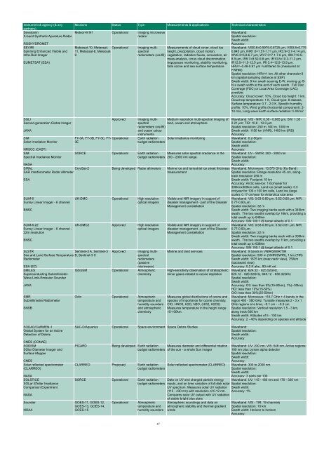
Instrument & agency (& any Missions Status Type Measurements & applications Technical characteristics<br />
partners)<br />
Severjanin<br />
X-band Syn<strong>the</strong>tic Aperature Radar<br />
ROSHYDROMET<br />
Meteor-M N1 Operational Imaging microwave<br />
radars<br />
Waveband:<br />
Spatial resolution:<br />
Swath width:<br />
Accuracy:<br />
SEVIRI<br />
Spinning Enhanced Visible and<br />
Infra-Red Imager<br />
Meteosat-10, Meteosat-<br />
11, Meteosat-8, Meteosat-<br />
9<br />
Operational<br />
EUMETSAT (ESA)<br />
SGLI<br />
Second-generation Global Imager<br />
JAXA<br />
SIM<br />
Solar Irradiation Monitor<br />
NRSCC (CAST)<br />
SIM<br />
Spectral Irradiance Monitor<br />
NASA<br />
SIRAL<br />
SAR Interferometer Radar Altimeter<br />
ESA<br />
SLIM-6<br />
Surrey Linear Imager - 6 channel<br />
BNSC<br />
SLIM-6-22<br />
Surrey Linear Imager - 6 channel -<br />
22m resolution<br />
BNSC<br />
Approved<br />
FY-3A, FY-3B, FY-3C, FY- Operational<br />
3E<br />
SLSTR<br />
Sentinel-3 A, Sentinel-3<br />
Sea and Land Surface Temperature B, Sentinel-3 C<br />
Radiometer<br />
ESA (EC)<br />
SMILES<br />
Superconducting Submillimeter-<br />
Wave Limb-Emission Sounder<br />
JAXA<br />
SMR<br />
Submillimetre Radiometer<br />
SNSB<br />
Imaging multispectral<br />
height, precipitation, cloud motion,<br />
Measurements of cloud cover, cloud top<br />
radiometers (vis/IR) vegetation, radiation fluxes, convection, air<br />
mass analysis, cirrus cloud discrimination,<br />
tropopause monitoring, stability monitoring,<br />
total ozone and sea surface temperature<br />
Imaging multispectral<br />
land, ocean and atmosphere<br />
Medium resolution multi-spectral imaging of<br />
radiometers (vis/IR)<br />
and ocean colour<br />
instruments<br />
Earth radiation Solar irradiance monitoring<br />
budget radiometers<br />
SORCE Operational Earth radiation Measures solar spectral irradiance in <strong>the</strong><br />
budget radiometers 200 - 2000 nm range.<br />
CryoSat-2 Being developed Radar altimeters Marine ice and terrestrial ice sheet thickness<br />
measurement<br />
UK-DMC Operational High resolution<br />
optical imagers<br />
UK-DMC2 Approved High resolution<br />
optical imagers<br />
Approved<br />
Imaging multispectral<br />
radiometers<br />
(passive<br />
microwave)<br />
ISS/JEM Operational Atmospheric<br />
chemistry<br />
Odin Operational Atmospheric<br />
temperature and<br />
humidity sounders<br />
and atmospheric<br />
chemistry<br />
Visible and NIR imagery in support of<br />
disaster management - part of <strong>the</strong> Disaster<br />
Management constellation<br />
Visible and NIR imagery in support of<br />
disaster management - part of <strong>the</strong> Disaster<br />
Management constellation<br />
Marine and land services<br />
High-sensitivity <strong>observation</strong> of stratospheric<br />
minor gases related to ozone depletion<br />
Measures global distributions of ozone and<br />
species of importance for ozone chemisty,<br />
ClO, HNO3, H2O, N2O, (HO2, H2O2).<br />
Measures temperature in <strong>the</strong> height range<br />
15-100km.<br />
Waveband: VIS0.6=0.5975-0.6725 µm, VIS0.8=0.775-<br />
0.845 µm, NIR1.6=1.57-1.71 µm, IR3.9=3.7-4.14 µm,<br />
WV6.3=5.8-6.7 µm, WV7.3=7.1-7.6 µm, IR8.7=8.5-<br />
8.9 µm, IR9.7=9.52-9.8 µm, IR10.8=10.3-11.3 µm,<br />
IR12.0=11.5-12.5 µm, IR13.4=12.9-13.9 µm,<br />
HRV=~0.48-0.91 µm =unfiltered Si (measured at<br />
FWHM)<br />
Spatial resolution: HRV=1 km, All o<strong>the</strong>r channels=3<br />
km (spatial sampling distance at SSP)<br />
Swath width: 9 km swath scannig E-W, moving up S-<br />
N a swath width at <strong>the</strong> end of each swath. Full Disc<br />
Coverage (FDC) or Local Area Coverage (LAC)<br />
possible.<br />
Accuracy: Cloud cover: 10%, Cloud top height: 1 km,<br />
Cloud top temperature: 1 K, Cloud type: 8 classes,<br />
Surface temperature: 0.7 - 2.0 K, Specific humidity<br />
profile: 10%, Wind profile (horizontal component): 2-<br />
10 m/s, Long wave Earth surface radiation: 5 W/m2<br />
Waveband: VIS - NIR: 0.38 - 0.865 µm, SW: 1.05 -<br />
2.21 µm; TIR: 10.8 - 12.0 µm<br />
Spatial resolution: 250 m, 500 m, 1000 m<br />
Swath width: 1150 km (VNR), 1400 km (IRS)<br />
Accuracy:<br />
Waveband: 0.2-50µm<br />
Spatial resolution:<br />
Swath width:<br />
Accuracy:<br />
Waveband: UV - SWIR: 200 - 2000 nm<br />
Spatial resolution:<br />
Swath width:<br />
Accuracy:<br />
Waveband: Microwave: 13.575 GHz (Ku-Band)<br />
Spatial resolution: Range resolution 45 cm, alongtrack<br />
resolution 250 m<br />
Swath width: Footprint 15 km<br />
Accuracy: Arctic sea-ice: 1.6cm/year for<br />
300kmx300km cells, Land ice (small scale): 3.3<br />
cm/year for 100 x 100 km cells, Land ice (large<br />
scale): 0.17 cm/year for Antarctica size area<br />
Waveband: VIS: 0.63-0.69 µm, 0.52-0.60 µm; NIR:<br />
0.77-0.90 µm.<br />
Spatial resolution: 32 m<br />
Swath width: Two imaging banks each with a 340km<br />
swath. The two swaths overlap by 16km, providing a<br />
total swath up to 648km<br />
Accuracy: S/N 100:1 @ target albedo of 0.1.<br />
Waveband: VIS: 0.63-0.69 µm, 0.52-0.61 µm; NIR:<br />
0.77-0.90 µm.<br />
Spatial resolution: 22 m<br />
Swath width: Two imaging banks each with a 330km<br />
swath. The two swaths overlap by 11km, providing a<br />
total swath up to 638km<br />
Accuracy: S/N 150:1 @ target albedo of 0.1.<br />
Waveband: 9 bands in VNIR/SWIR/TIR<br />
Spatial resolution: 500 m (VNIR/SWIR), 1 km (TIR)<br />
Swath width: 1675 km (near-nadir view), 750km<br />
(backward view)<br />
Accuracy: 0.2 K abs., 80 mK rel.<br />
Waveband: 624.32-625.52GHz,<br />
625.12-626.32GHz, 649.12-650.32GHz<br />
Spatial resolution:<br />
Swath width:<br />
Accuracy: O3: less than 5%(15-60km), 1%(~30km)<br />
HCl: less than 10%(15-50%)<br />
ClO: less than 30%(25-50km)<br />
Waveband: Microwave: 118.7 GHz + 4 bands in <strong>the</strong><br />
region 480 - 580 GHz: Tunable measures 2 - 3 x 1<br />
GHz regions at a time; ~0.1 cm - ~0.3 cm<br />
Spatial resolution: Vertical resolution 1.5 - 3 km,<br />
along track 600 km<br />
Swath width: Altitudes of 5 - 100 km<br />
Accuracy: 2 - 40% depending on species and altitude<br />
SODAD/CARMEN-1<br />
Orbital System for an Active<br />
Detection of Debris<br />
CNES (CONAE)<br />
SODISM<br />
SOlar Diameter Imager and<br />
Surface Mapper<br />
CNES<br />
Solar reflected spectrometer<br />
(CLARREO)<br />
NASA<br />
SOLSTICE<br />
SOLar STellar Irradiance<br />
Comparison Experiment<br />
NASA<br />
Sounder<br />
NOAA<br />
SAC-D/Aquarius Operational Space environment Space Debris Studies Waveband:<br />
Spatial resolution:<br />
Swath width:<br />
Accuracy:<br />
PICARD<br />
Being developed Earth radiation Measures diameter and differential rotation<br />
budget radiometers of <strong>the</strong> sun - a whole Sun imager<br />
CLARREO Proposed Earth radiation Solar reflected spectrometer (CLARREO)<br />
budget radiometers<br />
Waveband: UV: 230 nm, VIS: 548 nm, Active regions:<br />
160 nm plus Lyman alpha detector<br />
Spatial resolution:<br />
Swath width:<br />
Accuracy:<br />
Waveband: 300 to 2000 nm.<br />
Spatial resolution:<br />
Swath width:<br />
Accuracy: 3 parts per 100<br />
SORCE Operational Earth radiation Data on UV and charged particle energy Waveband: UV: 115 - 180 nm and 170 - 320 nm<br />
budget radiometers inputs, and on time variation of full-disk solar Spatial resolution:<br />
UV spectrum. Measures solar UV radiation<br />
(115 - 430 nm) with resolution of 0.12 nm.<br />
Swath width:<br />
Accuracy: 1%<br />
Compares solar UV output with UV radiation<br />
of stable bright blue stars<br />
GOES-11, GOES-12,<br />
GOES-13, GOES-14,<br />
GOES-15<br />
Operational<br />
Atmospheric<br />
temperature and<br />
humidity sounders<br />
Atmospheric soundings and data on<br />
atmospheric stability and <strong>the</strong>rmal gradient<br />
winds<br />
Waveband: VIS - TIR: 19 channels<br />
Spatial resolution: 10 km<br />
Swath width: Horizon to horizon<br />
Accuracy:<br />
47


