

the earth observation handbook
The Earth Observation Handbook - Key Tables - SEOCA
The Earth Observation Handbook - Key Tables - SEOCA
- No tags were found...

You also want an ePaper? Increase the reach of your titles
YUMPU automatically turns print PDFs into web optimized ePapers that Google loves.
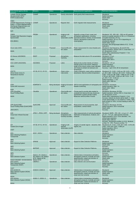
Instrument & agency (& any<br />
partners)<br />
CHAMP Gravity Package<br />
(Accelerometer+GPS)<br />
STAR Accelerometer<br />
CNES<br />
CHAMP Magnetometry Package (1<br />
Scalar + 2 Vector Magnetometer)<br />
Overhauser Magnetometer and<br />
Fluxgate Magnetometer<br />
DLR<br />
CHRIS<br />
Compact High Resolution Imaging<br />
Spectrometer<br />
ESA (BNSC)<br />
Cloud radar (ACE)<br />
NASA<br />
CO Sensor (ASCENDS)<br />
NASA<br />
CO2 LIDAR (ASCENDS)<br />
NASA<br />
COCTS<br />
China Ocean Colour &<br />
Temperature Scanner<br />
CAST<br />
COSI<br />
Corea SAR Instrument<br />
KARI<br />
CPR (CloudSat)<br />
Cloud Profiling Radar<br />
NASA<br />
CPR (EarthCARE)<br />
Cloud Profiling Radar (EarthCARE)<br />
JAXA (NICT)<br />
CrIS<br />
Cross-track Infrared Sounder<br />
NOAA<br />
CZI<br />
Coastal Zone Imager<br />
CAST<br />
DCS<br />
Data Collecting Plataform<br />
Transponder<br />
INPE<br />
DCS<br />
Data Collecting System<br />
INPE<br />
DCS<br />
Data Collecting System<br />
INPE<br />
DCS<br />
Data Collection System<br />
ROSHYDROMET (ROSKOSMOS)<br />
DCS (CAST)<br />
Data Collecting System<br />
Transponder (CAST)<br />
CAST<br />
DCS (GOES-R)<br />
Data Collection System (NOAA,<br />
GOES-R)<br />
NOAA<br />
DCS (NOAA)<br />
Data Collection System (NOAA)<br />
NOAA<br />
Missions Status Type Measurements & applications Technical characteristics<br />
CHAMP Operational Gravity instruments Earth gravity field measurements Waveband:<br />
Spatial resolution:<br />
Swath width:<br />
Accuracy:<br />
CHAMP Operational Magnetic field Earth magnetic field measurements Waveband:<br />
Spatial resolution:<br />
Swath width:<br />
Accuracy:<br />
PROBA Operational Imaging multispectral<br />
Supports a range of land, ocean and<br />
atmospheric applications, including<br />
radiometers (vis/IR) agricultural science, forestry, environmental<br />
science, atmospheric science and<br />
oceanography<br />
ACE Proposed Cloud profile and<br />
rain radars<br />
SWOT Proposed Atmospheric<br />
chemistry<br />
Radar measurement for cloud droplets and<br />
precipitation<br />
Measure <strong>the</strong> total column CO concentration. Waveband: 2.3 µm<br />
Spatial resolution:<br />
Swath width: 200 m<br />
Accuracy:<br />
ASCENDS Proposed Lidars Measure <strong>the</strong> number density of Carbon<br />
Dioxide (CO2) in <strong>the</strong> column. Measure<br />
length of <strong>the</strong> column using a laser altimeter<br />
and measure ambient air pressure and<br />
temperature.<br />
HY-1B, HY-1C, HY-1D Operational Ocean colour<br />
instruments<br />
KOMPSAT-5<br />
Being developed Imaging microwave<br />
radars<br />
CloudSat Operational Cloud profile and<br />
rain radars<br />
EarthCARE Approved Cloud profile and<br />
rain radars<br />
JPSS-1, JPSS-2, NPP<br />
Being developed Atmospheric<br />
temperature and<br />
humidity sounders<br />
Ocean chlorophyll, ocean yellow substance<br />
absorbance, Sea-ice surface temperature<br />
SAR for land applications of cartography and<br />
disaster monitoring<br />
Primary goal to provide data needed to<br />
evaluate and improve <strong>the</strong> way clouds are<br />
represented in global climate models.<br />
Measures vertical profile of clouds<br />
Measurement of cloud properties, light<br />
precipitation, vertical motion<br />
Daily measurements of vertical atmospheric<br />
distribution of temperature, moisture, and<br />
pressure<br />
HY-1B, HY-1C, HY-1D Operational Imaging multispectral<br />
Imagery of coastal regions - estuaries, tidal<br />
regions, etc.<br />
radiometers (vis/IR)<br />
Waveband: VIS - NIR: 400 - 1050 nm (63 spectral<br />
bands at a spatial resolution of 36 m; or 18 bands at<br />
full spatial resolution (18 m))<br />
Spatial resolution: 36 m or 18 m depending on<br />
wavebands selected.<br />
Swath width: 14 km<br />
Accuracy: S/N 200 @ target albedo of 0.2. 12 bits<br />
digitisation.<br />
Waveband: Dual frequency: 35 and 94 GHz<br />
Spatial resolution: Vertical: 250 m, Cross-track: 1.4<br />
km, Along-track: 2.5 km<br />
Swath width: Instantaneous Footprint < 1 km<br />
Accuracy: TBD<br />
Waveband: 1.57 µm<br />
Spatial resolution:<br />
Swath width: 200 m<br />
Accuracy: 1 ppm CO2; 2K for temperature<br />
Waveband: B1: 0.402 - 0.422 µm, B2: 0.433 - 0.453<br />
µm, B3: 0.480 - 0.500 µm, B4: 0.510 - 0.530 µm, B5:<br />
0.555 - 0.575 µm, B6: 0.660 - 0.680 µm, B7: 0.740 -<br />
0.760 µm, B8: 0.845 - 0.885 µm, B9: 10.30 - 11.40<br />
µm, B10: 11.40 - 12.50 µm<br />
Spatial resolution: 1.1 km<br />
Swath width: 3083 km<br />
Accuracy:<br />
Waveband: microwave<br />
Spatial resolution: High: 1m<br />
Swath width: 100km<br />
Accuracy:<br />
SCD-1, SCD-2 Operational Data collection Data collection Waveband:<br />
Spatial resolution:<br />
Swath width:<br />
Accuracy:<br />
GPM-Br Approved Data collection Support to Data Collection Platforms Waveband:<br />
Spatial resolution:<br />
Swath width:<br />
Accuracy:<br />
MAPSAR Approved Data collection Support to Data Collection Platforms Waveband:<br />
Spatial resolution:<br />
Swath width:<br />
Accuracy:<br />
Elektro-L N1, Elektro-L<br />
N2, Elektro-L N3, Meteor-<br />
M N1, Meteor-M N2,<br />
Meteor-M N3<br />
Operational Data collection Collects data on temperature (air/water),<br />
atmospheric pressure, humidity and wind<br />
speed/direction, speed and direction of<br />
ocean and river currents<br />
Waveband: Microwave: 94 GHz<br />
Spatial resolution: Vertical: 500 m, Cross-track: 1.4<br />
km, Along-track: 2.5 km<br />
Swath width: Instantaneous Footprint < 2 km<br />
Accuracy: detects ice clouds optical depth >1, water<br />
clouds optical depth >3, ice content to +100%, -50%,<br />
liquid content to


