the earth observation handbook
The Earth Observation Handbook - Key Tables - SEOCA
The Earth Observation Handbook - Key Tables - SEOCA
- No tags were found...
Create successful ePaper yourself
Turn your PDF publications into a flip-book with our unique Google optimized e-Paper software.
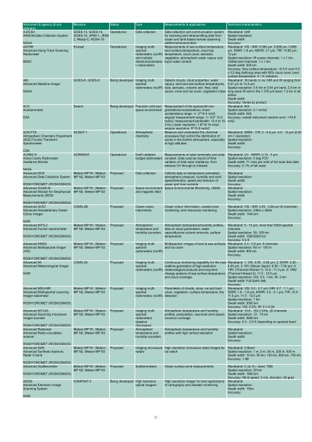
Instrument & agency (& any<br />
partners)<br />
A-DCS4<br />
ARGOS-Data Collection System<br />
NOAA<br />
AATSR<br />
Advanced Along-Track Scanning<br />
Radiometer<br />
BNSC<br />
ABI<br />
Advanced Baseline Imager<br />
NOAA<br />
ACC<br />
Accelerometer<br />
ESA<br />
ACE-FTS<br />
Atmospheric Chemistry Experiment<br />
(ACE) Fourier Transform<br />
Spectrometer<br />
CSA<br />
ACRIM III<br />
Active Cavity Radiometer<br />
Irradiance Monitor<br />
NASA<br />
Advanced DCS<br />
Advanced Data Collection System<br />
ROSHYDROMET (ROSKOSMOS)<br />
Advanced GOCI<br />
Advanced Geostationary Ocean<br />
Colour Imager<br />
Missions Status Type Measurements & applications Technical characteristics<br />
GOES-13, GOES-14,<br />
GOES-15, JPSS-1, JPSS-<br />
2, Metop-C, NOAA-19<br />
Operational Data collection Data collection and communication system<br />
for receiving and retransmitting data from<br />
ocean and land-based remote observing<br />
platforms/transponders<br />
Envisat Operational Imaging multispectral<br />
Measurements of sea surface temperature,<br />
land surface temperature, cloud top<br />
radiometers (vis/IR) temperature, cloud cover, aerosols,<br />
and multiple vegetation, atmospheric water vapour and<br />
direction/polarisatio liquid water content<br />
n radiometers<br />
GOES-R, GOES-S<br />
Swarm<br />
Being developed Imaging multispectral<br />
radiometers (vis/IR)<br />
Being developed Precision orbit and<br />
space environment<br />
SCISAT-1 Operational Atmospheric<br />
chemistry<br />
Detects clouds, cloud properties, water<br />
vapour, land and sea surface temperatures,<br />
dust, aerosols, volcanic ash, fires, total<br />
ozone, snow and ice cover, vegetation index<br />
Measurement of <strong>the</strong> spacecraft nongravitational<br />
accelerations, linear<br />
accelerations range: +/- 2*10-4 m/s2;<br />
angular measurement range: +/- 9.6* 10-3<br />
rad/s2; measurement bandwidth: 10-4 to 10-<br />
2 Hz; Linear resolution: 1.8*10-10 m/s2;<br />
angular resolution: 8*10-9 rad/s2<br />
Measure and understand <strong>the</strong> chemical<br />
processes that control <strong>the</strong> distribution of<br />
ozone in <strong>the</strong> Earth's atmosphere, especially<br />
at high altitudes.<br />
ACRIMSAT Operational Earth radiation<br />
budget radiometers<br />
Measurements of solar luminosity and solar<br />
constant. Data used as record of time<br />
variation of total solar irradiance, from<br />
extreme UV through to infrared<br />
Meteor-MP N1, Meteor-<br />
MP N2, Meteor-MP N3<br />
ROSHYDROMET (ROSKOSMOS)<br />
Advanced GGAK-M<br />
Meteor-MP N1, Meteor-<br />
Advanced Module for Geophysical MP N2, Meteor-MP N3<br />
Measurements (SEM)<br />
KARI<br />
Advanced IKFS-2<br />
Advanced Fourier spectrometer<br />
ROSHYDROMET (ROSKOSMOS)<br />
Advanced KMSS<br />
Advanced Multispectral Imager<br />
(VIS)<br />
ROSHYDROMET (ROSKOSMOS)<br />
Advanced MI<br />
Advanced Meteorological Imager<br />
KARI<br />
Advanced MSU-MR<br />
Advanced Multispectral scanning<br />
imager-radiometer<br />
ROSHYDROMET (ROSKOSMOS)<br />
Advanced MTVZA<br />
Advanced Scanning microwave<br />
imager-sounder<br />
ROSHYDROMET (ROSKOSMOS)<br />
Advanced Radiomet<br />
Advanced Radio-occultation<br />
receiver<br />
ROSHYDROMET (ROSKOSMOS)<br />
Advanced SAR<br />
Advanced Syn<strong>the</strong>tic Aperture<br />
Radar X band<br />
ROSHYDROMET (ROSKOSMOS)<br />
Advanced Scatterometer<br />
ROSHYDROMET (ROSKOSMOS)<br />
AEISS<br />
Advanced Electronic Image<br />
Scanning System<br />
KARI<br />
Proposed Data collection Collects data on temperature (air/water),<br />
atmospheric pressure, humidity and wind<br />
speed/direction, speed and direction of<br />
ocean and river currents<br />
Proposed Space environment Space Environmental Monitoring (SEM)<br />
and magnetic field<br />
COMS-2B Proposed Ocean colour<br />
instruments<br />
Meteor-MP N1, Meteor-<br />
MP N2, Meteor-MP N3<br />
Meteor-MP N1, Meteor-<br />
MP N2, Meteor-MP N3<br />
Proposed<br />
Proposed<br />
Atmospheric<br />
temperature and<br />
humidity sounders<br />
Ocean colour information, coastal zone<br />
monitoring, land resources monitoring<br />
Atmospheric temperature/humidity profiles,<br />
data on cloud parameters, water<br />
vapour&ozone column amounts, surface<br />
temperature<br />
Waveband: UHF<br />
Spatial resolution:<br />
Swath width:<br />
Accuracy:<br />
Waveband: VIS - NIR: 0.555 µm, 0.659 µm, 0.865<br />
µm, SWIR: 1.6 µm, MWIR: 3.7 µm, TIR: 10.85 µm,<br />
12 µm<br />
Spatial resolution: IR ocean channels: 1 x 1 km,<br />
Visible land channels: 1 x 1 km<br />
Swath width: 500 km<br />
Accuracy: Sea surface temperature:


