

the earth observation handbook
The Earth Observation Handbook - Key Tables - SEOCA
The Earth Observation Handbook - Key Tables - SEOCA
- No tags were found...

You also want an ePaper? Increase the reach of your titles
YUMPU automatically turns print PDFs into web optimized ePapers that Google loves.
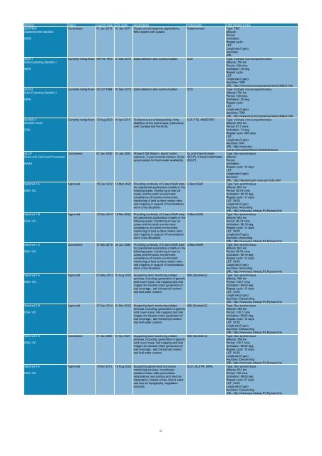
Mission Status Launch Date EOL Date Applications Instruments Orbit Details & URL<br />
SCATSAT<br />
Scatterometer Satellite<br />
ISRO<br />
Considered 01 Jan 2013 01 Jan 2017 Ocean and atmosphere applications,<br />
Wind speed over oceans<br />
Scatterometer<br />
Type: TBD<br />
Altitude:<br />
Period:<br />
Inclination:<br />
Repeat cycle:<br />
LST:<br />
Longitude (if geo):<br />
Asc/desc:<br />
URL:<br />
SCD-1<br />
Data Collecting Satellite 1<br />
INPE<br />
SCD-2<br />
Data Collecting Satellite 2<br />
INPE<br />
SCISAT-1<br />
SCISAT-I/ACE<br />
CSA<br />
SCLP<br />
Snow and Cold Land Processes<br />
NASA<br />
Sentinel-1 A<br />
ESA / EC<br />
Sentinel-1 B<br />
ESA / EC<br />
Sentinel-1 C<br />
ESA / EC<br />
Sentinel-2 A<br />
ESA / EC<br />
Sentinel-2 B<br />
ESA / EC<br />
Sentinel-2 C<br />
ESA / EC<br />
Sentinel-3 A<br />
ESA / EC<br />
Currently being flown 09 Feb 1993 01 Dec 2010 Data collection and communication DCS Type: Inclined, non-sunsynchronous<br />
Altitude: 750 km<br />
Period: 100 mins<br />
Inclination: 25 deg<br />
Repeat cycle:<br />
LST:<br />
Longitude (if geo):<br />
Asc/desc: TBD<br />
URL: http://www.inpe.br/programas/mecb/default.htm<br />
Currently being flown 22 Oct 1998 01 Dec 2012 Data collection and communication DCS Type: Inclined, non-sunsynchronous<br />
Altitude: 750 km<br />
Period: 100 mins<br />
Inclination: 25 deg<br />
Repeat cycle:<br />
LST:<br />
Longitude (if geo):<br />
Asc/desc: TBD<br />
URL: http://www.inpe.br/programas/mecb/default.htm<br />
Currently being flown 12 Aug 2003 01 Apr 2013 To improve our understanding of <strong>the</strong><br />
depletion of <strong>the</strong> ozone layer, particularly<br />
over Canada and <strong>the</strong> Arctic.<br />
Considered 01 Jan 2030 01 Jan 2033 Phase-2 DS Mission, launch order<br />
unknown, 3-year nominal mission. Snow<br />
accumulation for fresh water availability<br />
ACE-FTS, MAESTRO<br />
Approved 15 Dec 2012 15 Mar 2020 Providing continuity of C-band SAR data C-Band SAR<br />
for operational applications notably in <strong>the</strong><br />
following areas: monitoring of sea ice<br />
zones and <strong>the</strong> arctic environment,<br />
surveillance of marine environment,<br />
monitoring of land surface motion risks<br />
and mapping in support of humanitarian<br />
aid in crisis situations<br />
Approved 15 Dec 2014 15 Mar 2022 Providing continuity of C-band SAR data C-Band SAR<br />
for operational applications notably in <strong>the</strong><br />
following areas: monitoring of sea ice<br />
zones and <strong>the</strong> arctic environment,<br />
surveillance of marine environment,<br />
monitoring of land surface motion risks<br />
and mapping in support of humanitarian<br />
aid in crisis situations<br />
Considered 31 Mar 2019 30 Jun 2026 Providing continuity of C-band SAR data C-Band SAR<br />
for operational applications notably in <strong>the</strong><br />
following areas: monitoring of sea ice<br />
zones and <strong>the</strong> arctic environment,<br />
surveillance of marine environment,<br />
monitoring of land surface motion risks<br />
and mapping in support of humanitarian<br />
aid in crisis situations<br />
Ku and X-band radars<br />
(SCLP), K band radiometers<br />
(SCLP)<br />
Approved 01 May 2013 01 Aug 2020 Supporting land monitoring related<br />
services, including: generation of generic<br />
land cover maps, risk mapping and fast<br />
images for disaster relief, generation of<br />
leaf coverage, eaf chlorophyll content<br />
and leaf water content<br />
MSI (Sentinel-2)<br />
Approved 31 Dec 2014 31 Mar 2022 Supporting land monitoring related<br />
services, including: generation of generic<br />
land cover maps, risk mapping and fast<br />
images for disaster relief, generation of<br />
leaf coverage, eaf chlorophyll content<br />
and leaf water content<br />
MSI (Sentinel-2)<br />
Considered 01 Jan 2020 01 Apr 2027 Supporting land monitoring related<br />
services, including: generation of generic<br />
land cover maps, risk mapping and fast<br />
images for disaster relief, generation of<br />
leaf coverage, eaf chlorophyll content<br />
and leaf water content<br />
MSI (Sentinel-2)<br />
Approved 15 Apr 2013 15 Aug 2020 Supporting global land and ocean<br />
monitoring services, in particular:<br />
sea/land colour data and surface<br />
temperature; sea surface and land ice<br />
topography; coastal zones, inland water<br />
and sea ice topography; vegetation<br />
products<br />
OLCI, SLSTR, SRAL<br />
Type: Inclined, non-sunsynchronous<br />
Altitude: 650 km<br />
Period: 97.7 mins<br />
Inclination: 74 deg<br />
Repeat cycle: 365 days<br />
LST:<br />
Longitude (if geo):<br />
Asc/desc: N/A<br />
URL: http://www.asccsa.gc.ca/eng/satellites/scisat/default.asp<br />
Type: Sun-synchronous<br />
Altitude:<br />
Period:<br />
Inclination:<br />
Repeat cycle: 15 days<br />
LST:<br />
Longitude (if geo):<br />
Asc/desc:<br />
URL: http://decadal.gsfc.nasa.gov/sclp.html<br />
Type: Sun-synchronous<br />
Altitude: 693 km<br />
Period: 98.74 mins<br />
Inclination: 98.19 deg<br />
Repeat cycle: 12 days<br />
LST: 18:00<br />
Longitude (if geo):<br />
Asc/desc: Ascending<br />
URL: http://www.esa.int/esaLP/LPgmes.html<br />
Type: Sun-synchronous<br />
Altitude: 693 km<br />
Period: 98.74 mins<br />
Inclination: 98.19 deg<br />
Repeat cycle: 12 days<br />
LST: 18:00<br />
Longitude (if geo):<br />
Asc/desc: Ascending<br />
URL: http://www.esa.int/esaLP/LPgmes.html<br />
Type: Sun-synchronous<br />
Altitude: 693 km<br />
Period: 98.74 mins<br />
Inclination: 98.19 deg<br />
Repeat cycle: 12 days<br />
LST: 18:00<br />
Longitude (if geo):<br />
Asc/desc: Ascending<br />
URL: http://www.esa.int/esaLP/LPgmes.html<br />
Type: Sun-synchronous<br />
Altitude: 786 km<br />
Period: 100.7 mins<br />
Inclination: 98.62 deg<br />
Repeat cycle: 10 days<br />
LST: 10:30<br />
Longitude (if geo):<br />
Asc/desc: Descending<br />
URL: http://www.esa.int/esaLP/LPgmes.html<br />
Type: Sun-synchronous<br />
Altitude: 786 km<br />
Period: 100.7 mins<br />
Inclination: 98.62 deg<br />
Repeat cycle: 10 days<br />
LST: 10:30<br />
Longitude (if geo):<br />
Asc/desc: Descending<br />
URL: http://www.esa.int/esaLP/LPgmes.html<br />
Type: Sun-synchronous<br />
Altitude: 786 km<br />
Period: 100.7 mins<br />
Inclination: 98.62 deg<br />
Repeat cycle: 10 days<br />
LST: 10:30<br />
Longitude (if geo):<br />
Asc/desc: Descending<br />
URL: http://www.esa.int/esaLP/LPgmes.html<br />
Type: Sun-synchronous<br />
Altitude: 814 km<br />
Period: 100 mins<br />
Inclination: 98.65 deg<br />
Repeat cycle: 27 days<br />
LST: 10:00<br />
Longitude (if geo):<br />
Asc/desc: Descending<br />
URL: http://www.esa.int/esaLP/LPgmes.html<br />
22


