

the earth observation handbook
The Earth Observation Handbook - Key Tables - SEOCA
The Earth Observation Handbook - Key Tables - SEOCA
- No tags were found...

You also want an ePaper? Increase the reach of your titles
YUMPU automatically turns print PDFs into web optimized ePapers that Google loves.
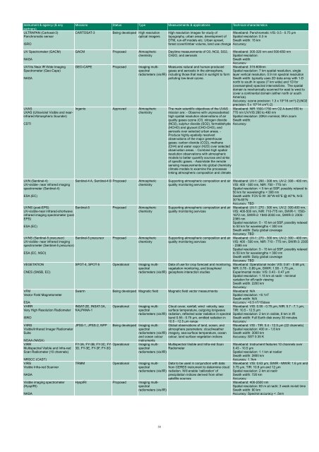
Instrument & agency (& any<br />
partners)<br />
ULTRAPAN (Cartosat-3)<br />
Panchromatic sensor<br />
ISRO<br />
Missions Status Type Measurements & applications Technical characteristics<br />
CARTOSAT-3<br />
Being developed High resolution<br />
optical imagers<br />
High resolution images for study of Waveband: Panchromatic VIS: 0.5 - 0.75 µm<br />
topography, urban areas, development of Spatial resolution: 0.3 m<br />
DTM, run-off models etc. Urban sprawl, Swath width: 15 km<br />
forest cover/timber volume, land use change Accuracy:<br />
UV Spectrometer (GACM)<br />
NASA<br />
UV/Vis Near IR Wide Imaging<br />
Spectrometer (Geo-Cape)<br />
NASA<br />
UVAS<br />
UVAS (Ultraviolet Visible and nearinfrared<br />
Atmospheric Sounder)<br />
CDTI<br />
UVN (Sentinel-4)<br />
UV-visible- near infrared imaging<br />
spectrometer (Sentinel-4)<br />
ESA (EC)<br />
GACM Proposed Atmospheric<br />
chemistry<br />
Daytime measurements of O3, NO2, SO2,<br />
CH2O, and aerosols<br />
GEO-CAPE Proposed Imaging multispectral<br />
Measures natural and human-produced<br />
gases and aerosols in <strong>the</strong> atmosphere,<br />
radiometers (vis/IR) including those that react in sunlight to form<br />
polluting low-level ozone.<br />
Ingenio Approved Atmospheric<br />
chemistry<br />
Sentinel-4 A, Sentinel-4 B Proposed<br />
Atmospheric<br />
chemistry<br />
UVNS (post-EPS)<br />
UV-visible-near infrared-shortwave<br />
infrared imaging spectrometer (post-<br />
EPS)<br />
Sentinel-5 Proposed Atmospheric<br />
chemistry<br />
ESA (EC)<br />
UVNS (Sentinel-5 precursor)<br />
UV-visible- near infrared imaging<br />
spectrometer (Sentinel-5 precursor)<br />
ESA (EC, NSO)<br />
VEGETATION<br />
CNES (SNSB, EC)<br />
VFM<br />
Vector Field Magnetometer<br />
ESA<br />
VHRR<br />
Very High Resolution Radiometer<br />
ISRO<br />
VIIRS<br />
Visible/Infrared Imager Radiometer<br />
Suite<br />
NOAA (NASA)<br />
VIRR<br />
Multispectral Visible and Infra-red<br />
Scan Radiometer (10 channels)<br />
NRSCC (CAST)<br />
VIRS<br />
Visible Infra-red Scanner<br />
NASA<br />
Visible imaging spectrometer<br />
(HyspIRI)<br />
NASA<br />
Sentinel-5 precursor Proposed Atmospheric<br />
chemistry<br />
SPOT-4, SPOT-5 Operational Imaging multispectral<br />
radiometers (vis/IR)<br />
Waveband: 305-320 nm and 500-650 nm<br />
Spatial resolution:<br />
Swath width:<br />
Accuracy:<br />
Waveband: 315-600nm<br />
Spatial resolution: 7 km spatial resolution, single<br />
layer vertical resolution, 0.9 nm spectral resolution<br />
Swath width: typically uses 2D data array with 1-D<br />
north to south in space (7 km wide) and 1D for<br />
(oversampled) spectral intervals/bins. The spatial<br />
domain is mechanically scanned for east to west to<br />
cover a continental domain (ei<strong>the</strong>r north or south<br />
America).<br />
Accuracy: ozone precision: 1.3 x 10^16 cm^(-2);NO2<br />
precision: 5 x 10^14 cm^(-2)<br />
The main scientific objectives of <strong>the</strong> UVAS Waveband: NIR 1500-1750 nm O2 A-band 650 to<br />
mission are: - Observe with unprecedented 770 nm UV/VIS 290 to 490 nm<br />
high spatial resolution <strong>observation</strong>s of air Spatial resolution: 20Km nominal, 5Km zoom<br />
quality gases ozone (O3, nitrogen dioxide Swath width:<br />
(NO2), sulphur dioxide (SO2), formaldehyde Accuracy:<br />
(HCHO) and glyoxal (CHO-CHO), and<br />
aerosols over selected urban areas. -<br />
Produce highly-spatially resolved<br />
<strong>observation</strong>s of <strong>the</strong> major greenhouse<br />
gases: carbon dioxide (CO2), methane<br />
(CH4) and water vapor (H2O) over selected<br />
<strong>observation</strong> areas. - Combine high spatial<br />
resolution <strong>observation</strong>s with atmospheric<br />
models to better quantify sources and sinks<br />
of specific gases. - Assimilate <strong>the</strong> remote<br />
sensing measurements into global chemistryclimate<br />
models to examine <strong>the</strong> processes<br />
linking atmospheric composition and climate.<br />
Supporting atmospheric composition and air<br />
quality monitoring services<br />
Supporting atmospheric composition and air<br />
quality monitoring services<br />
Supporting atmospheric composition and air<br />
quality monitoring services<br />
Data of use for crop forecast and monitoring,<br />
vegetation monitoring, and biosphere/<br />
geosphere interaction studies<br />
Waveband: UV-1: 290 - 308 nm, UV-2: 308 - 400 nm,<br />
VIS: 400 - 500 nm, NIR: 750 - 775 nm<br />
Spatial resolution: < 5 km at SSP, possibly relaxed to<br />
50 km for wavelengths < 308 nm<br />
Swath width: FOV E-W: 30°W-45°E @ 40°N, N-S:<br />
30°N-65°N<br />
Accuracy: TBD<br />
Waveband: UV-1: 270 - 300 nm, UV-2: 300-400 nm,<br />
VIS: 400-500 nm, NIR: 710-775 nm, SWIR-1: 1593-<br />
1672 nm, SWIR-2: 1940-2030 nm, SWIR-3: 2305-<br />
2385 nm<br />
Spatial resolution: 5 - 15 km at SSP, possibly relaxed<br />
to 50 km for wavelengths < 300 nm<br />
Swath width: Daily global coverage<br />
Accuracy: TBD<br />
Waveband: UV-1: 270 - 300 nm, UV-2: 300 - 400 nm,<br />
VIS: 400 - 500 nm, NIR: 710 - 775 nm, SWIR-3: 2305<br />
- 2385 nm<br />
Spatial resolution: 5 - 15 km at SSP, possibly relaxed<br />
to 50 km for wavelengths < 300 nm<br />
Swath width: Daily global coverage<br />
Accuracy: TBD<br />
Waveband: Operational mode: VIS: 0.61 - 0.68 µm,<br />
NIR: 0.78 - 0.89 µm, SWIR: 1.58 - 1.75 µm,<br />
Experimental mode: VIS: 0.43 - 0.47 µm<br />
Spatial resolution: 1.15 km at nadir - minimal<br />
variation for off-nadir viewing<br />
Swath width: 2200 km<br />
Accuracy:<br />
Swarm Being developed Magnetic field Magnetic field vector measurments Waveband: N/A<br />
Spatial resolution:


