

the earth observation handbook
The Earth Observation Handbook - Key Tables - SEOCA
The Earth Observation Handbook - Key Tables - SEOCA
- No tags were found...

You also want an ePaper? Increase the reach of your titles
YUMPU automatically turns print PDFs into web optimized ePapers that Google loves.
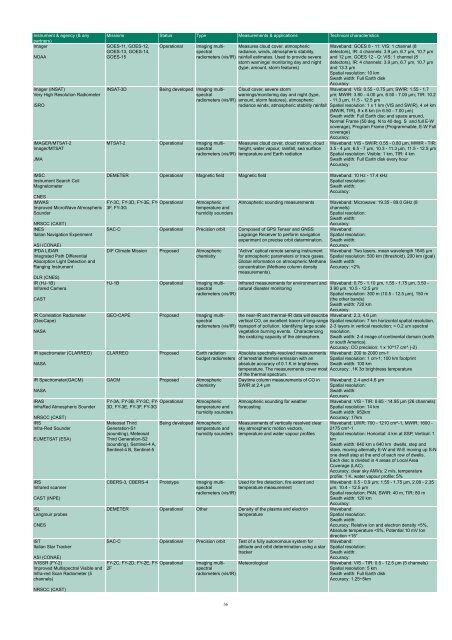
Instrument & agency (& any<br />
partners)<br />
Imager<br />
NOAA<br />
Imager (INSAT)<br />
Very High Resolution Radiometer<br />
ISRO<br />
IMAGER/MTSAT-2<br />
Imager/MTSAT<br />
JMA<br />
Missions Status Type Measurements & applications Technical characteristics<br />
GOES-11, GOES-12,<br />
GOES-13, GOES-14,<br />
GOES-15<br />
INSAT-3D<br />
Operational<br />
Imaging multispectral<br />
radiance, winds, atmospheric stability,<br />
Measures cloud cover, atmospheric<br />
radiometers (vis/IR) rainfall estimates. Used to provide severe<br />
storm warnings/ monitoring day and night<br />
(type, amount, storm features)<br />
Being developed Imaging multispectral<br />
warnings/monitoring day and night (type,<br />
Cloud cover, severe storm<br />
radiometers (vis/IR) amount, storm features), atmospheric<br />
radiance winds, atmospheric stability rainfall<br />
MTSAT-2 Operational Imaging multispectral<br />
Measures cloud cover, cloud motion, cloud<br />
height, water vapour, rainfall, sea surface<br />
radiometers (vis/IR) temparature and Earth radiation<br />
Waveband: GOES 8 - 11: VIS: 1 channel (8<br />
detectors), IR: 4 channels: 3.9 µm, 6.7 µm, 10.7 µm<br />
and 12 µm, GOES 12 - Q: VIS: 1 channel (8<br />
detectors), IR: 4 channels: 3.9 µm, 6.7 µm, 10.7 µm<br />
and 13.3 µm<br />
Spatial resolution: 10 km<br />
Swath width: Full Earth disk<br />
Accuracy:<br />
Waveband: VIS: 0.55 - 0.75 µm; SWIR: 1.55 - 1.7<br />
µm; MWIR: 3.80 - 4.00 µm, 6.50 - 7.00 µm; TIR: 10.2<br />
- 11.3 µm, 11.5 - 12.5 µm<br />
Spatial resolution: 1 x 1 km (VIS and SWIR), 4 x4 km<br />
(MWIR, TIR), 8 x 8 km (in 6.50 - 7.00 µm)<br />
Swath width: Full Earth disc and space around,<br />
Normal Frame (50 deg. N to 40 deg. S and full E-W<br />
coverage), Program Frame (Programmable, E-W Full<br />
coverage)<br />
Accuracy:<br />
Waveband: VIS - SWIR: 0.55 - 0.80 µm, MWIR - TIR:<br />
3.5 - 4 µm, 6.5 - 7 µm, 10.3 - 11.3 µm, 11.5 - 12.5 µm<br />
Spatial resolution: Visible: 1 km, TIR: 4 km<br />
Swath width: Full Earth disk every hour<br />
Accuracy:<br />
IMSC<br />
Instrument Search Coil<br />
Magnetometer<br />
NRSCC (CAST)<br />
INES<br />
Italian Navigation Experiment<br />
DEMETER Operational Magnetic field Magnetic field Waveband: 10 Hz - 17.4 kHz<br />
Spatial resolution:<br />
Swath width:<br />
Accuracy:<br />
CNES<br />
IMWAS<br />
FY-3C, FY-3D, FY-3E, FY- Operational<br />
Improved MicroWave Atmospheric 3F, FY-3G<br />
Sounder<br />
ASI (CONAE)<br />
IPDA LIDAR<br />
Integrated Path Differential<br />
Absorption Light Detection and<br />
Ranging Instrument<br />
DLR (CNES)<br />
IR (HJ-1B)<br />
Infrared Camera<br />
CAST<br />
IR Correlation Radiometer<br />
(GeoCape)<br />
NASA<br />
IR spectrometer (CLARREO)<br />
NASA<br />
IR Spectrometer(GACM)<br />
NASA<br />
IRAS<br />
InfraRed Atmospheric Sounder<br />
NRSCC (CAST)<br />
IRS<br />
Infra-Red Sounder<br />
EUMETSAT (ESA)<br />
IRS<br />
Infrared scanner<br />
CAST (INPE)<br />
ISL<br />
Langmuir probes<br />
CNES<br />
IST<br />
Italian Star Tracker<br />
Atmospheric<br />
temperature and<br />
humidity sounders<br />
SAC-C Operational Precision orbit Composed of GPS Tensor and GNSS<br />
Lagrange Receiver to perform navigation<br />
experiment on precise orbit determination.<br />
D/F Climate Mission Proposed Atmospheric<br />
chemistry<br />
Atmospheric sounding measurements Waveband: Microwave: 19.35 - 89.0 GHz (8<br />
channels)<br />
Spatial resolution:<br />
Swath width:<br />
Accuracy:<br />
“Active“ optical remote sensing instrument<br />
for atmospheric parameters or trace gases.<br />
Global information on atmospheric Methane<br />
concentration (Methane column density<br />
measurements).<br />
HJ-1B Operational Imaging multispectral<br />
Infrared measurements for environment and<br />
natural disaster monitoring<br />
radiometers (vis/IR)<br />
GEO-CAPE Proposed Imaging multispectral<br />
radiometers (vis/IR)<br />
Waveband:<br />
Spatial resolution:<br />
Swath width:<br />
Accuracy:<br />
Waveband: Two lasers, mean wavelength 1645 µm<br />
Spatial resolution: 500 km (threshold), 200 km (goal)<br />
Swath width:<br />
Accuracy:


