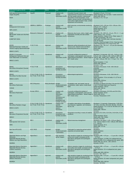
Instrument & agency (& any partners) Multi-spectral <strong>the</strong>rmal infrared imager (HyspIRI) NASA Missions Status Type Measurements & applications Technical characteristics HyspIRI Proposed Imaging multispectral Ecosystem focused mission with Waveband: 3-5 µm, 7.5-12 µm measurements of surface and cloud imaging Spatial resolution: 60 m at nadir; 1 week revisit time radiometers (vis/IR) with high spatial resolution, stereoscopic <strong>observation</strong> of local topography, cloud Swath width: 600 km Accuracy: 0.1 K,
Instrument & agency (& any partners) NIRST New Infrared Sensor Technology CONAE (CSA) NOAA Comms Communications package for NOAA NOAA Occultation GNSS Receiver (CLARREO) NASA OCM Ocean Colour Monitor Missions Status Type Measurements & applications Technical characteristics SAC-D/Aquarius NOAA-15, NOAA-16, NOAA-17, NOAA-18, NOAA-19 Being developed Imaging multispectral (HTE), caused by biomass fires, volcanic NIRST detects High Temperature Events radiometers (vis/IR) eruptions, and o<strong>the</strong>r phenomena in order to measure <strong>the</strong>ir temperatures, and <strong>the</strong>ir released energy over land (fires & volcanic events). Supplementary measurements of land surface (LST) and sea surface temperatures (SST) of <strong>the</strong> coasts of South America and o<strong>the</strong>r targets of opportunity with Accuracy: 0.6 ºC 180 km swath, overlapping <strong>the</strong> Aquarius inner beams Operational Communications Waveband: Spatial resolution: Swath width: Accuracy: Waveband: Infrared push-broom scanner based on 2 linear uncooled microbolometric arrays sensitive to Mid-Wave Infra-Red (3.8 µm) and Long-Wave Infra- Red (10.85 and 11.85 µm) spectral bands respectively Spatial resolution: Space resol: 350 m; less burned area detectable: 200 sqm Swath width: Instant: 182 km; Extended: 1000 km CLARREO Proposed Earth radiation budget radiometers Independent measurements of atmospheric temperature, pressure, and humidity using Waveband: IR:200 - 2000 cm-1; UV,VIS, and near IR: 380 to 2500nm Global Positioning System (GPS) occultation Spatial resolution: Spectral resolution in <strong>the</strong> UV, VIS, measurements of atmospheric refraction. and near IR of 15 nm; in <strong>the</strong> IR of 1cm-1 Swath width: VIS: 1km IFOV over 100km swath; 100km FOV Accuracy: .1K OCEANSAT-1, OCEANSAT-2 Operational Ocean colour instruments ISRO OCM (OCEANSAT-3) OCEANSAT-3 Proposed Ocean colour Ocean Colour Monitor (OCEANSAT- instruments 3) ISRO OCS Ocean colour scanner ROSHYDROMET (ROSKOSMOS) OES Ocean Ecosystem Spectrometer NASA OLCI Ocean and Land Colour Imager ESA (EC) OLI Operational Land Imager NASA (USGS) OLS Operational Linescan System NOAA (DoD (USA)) OMI Ozone Measuring Instrument NSO (NASA) OMPS Ozone Mapping and Profiler Suite NOAA Optical or HyperSpectral (TBD) JAXA OSIRIS Optical Spectrograph and Infra-Red Imaging System CSA (SNSB) Overhauser Magnetometer OM CNES PALSAR Phased Array type L-band Syn<strong>the</strong>tic Aperture Radar JAXA (METI) Meteor-M N3 Being developed Ocean colour instruments PACE Proposed Ocean colour instruments Sentinel-3 A, Sentinel-3 B, Sentinel-3 C LDCM Approved DMSP F-14, DMSP F-15, Operational DMSP F-16, DMSP F-17, DMSP F-18, DMSP F-19, DMSP F-20 Imaging multispectral radiometers (passive microwave) Being developed Imaging multispectral radiometers (vis/IR) Imaging multispectral radiometers (vis/IR) Aura Operational Atmospheric chemistry JPSS-1, JPSS-2, NPP Being developed Atmospheric chemistry Ocean colour data, Estimation of Waveband: VIS - NIR: 0.40 - 0.88 µm (8 channels) phytoplankton concentration, identification of Spatial resolution: 236 x 360m potential fishing zones, assessment of primary productivity Swath width: 1440 km Accuracy: Ocean colour data, Estimation of Waveband: 12 channel phytoplankton concentration, identification of Spatial resolution: potential fishing zones, assessment of Swath width: primary productivity Accuracy: Ocean color data, estimation of phytoplankton concentration Ocean color spectrometer for measuring ocean leaving light which contains information on biological components Marine and land services Measures surface radiance and emittance, land cover state and change (eg vegetation type). Used as multi-purpose imagery for land applications Waveband: 0.41 - 0.9 µm, 8 channels Spatial resolution: 1 km Swath width: 3000 km Accuracy: TBD Waveband: Near UV-Vis (360-710nm); NIR (748- 865nm); SWIR (1245, 1640, 2135 nm) Spatial resolution: 1 km Swath width: 2500 km swath Accuracy: Waveband: 21 bands in VNIR/SWIR Spatial resolution: 300 m Swath width: 1270 km, across-track tilt 12.2 deg to <strong>the</strong> West Accuracy: 2% abs, 0.1% rel. Waveband: VIS - SWIR: 9 bands: 0.43 - 2.3 µm Spatial resolution: Pan: 15 m, VIS - SWIR: 30 m Swath width: 185 km Accuracy: Absolute geodetic accuracy of 65 m; relative geodetic accuracy of 25 m (excluding terrain effects); geometric accuracy of 12 m or better Day and night cloud cover imagery Waveband: VIS - NIR: 0.4 - 1.1 µm, TIR: 10.0 - 13.4 µm, and 0.47 - 0.95 µm Spatial resolution: 0.56 km (fine), 5.4 km (stereo products) Swath width: 3000 km Accuracy: Mapping of ozone columns, key air quality components (NO2, SO2, BrO, OClO and aerosols), measurements of cloud pressure and coverage, global distribution and trends in UV-B radiation Measures total amount of ozone in <strong>the</strong> atmosphere and <strong>the</strong> ozone concentration variation with altitude ALOS-3 Proposed TBD Waveband: Spatial resolution: Swath width: Accuracy: Odin Operational Atmospheric chemistry Detects aerosol layers and abundance of species such as O3, NO2, OClO, and NO. Consists of spectrograph and IR imager. Measures temperature for altitudes above 30km. Ørsted (Oersted) Operational Magnetic field Measurements of <strong>the</strong> strength of <strong>the</strong> Earth's magnetic field ALOS Operational Imaging microwave radars High resolution microwave imaging of land and ice for use in environmental monitoring, agriculture and forestry, disaster monitoring, Earth resource management and interferometry Waveband: UV: 270 - 314 nm and 306 - 380 nm, VIS: 350 - 500 nm Spatial resolution: 13 x 24 km or 36 x 48 km depending on <strong>the</strong> product. Also has zoom modes (13 x 13 km) for example for urban pollution detection Swath width: 2600 km Accuracy: Waveband: Nadir Mapper: UV 0.3 - 0.38 µm, Nadir profiler: UV 0.25 - 0.31 µm, Limb soundings: UV - TIR 0.29 - 10 µm Spatial resolution: Mapper: 50 km, Profiler: 250 km, Limb: 1 km vertical Swath width: Mapper: 2800 km, Profiler: 250 km, Limb: 3 vertical slits along track +/- 250 km Accuracy: Total Ozone 15 Dobson units. Profile Ozone 10% between 15 and 60 km; 20% between Tropopause and 15 km Waveband: Spectrograph: UV - NIR: 0.28 - 0.80 µm; IR Imager: NIR: 1.26 µm, 1.27 µm, 1.52 µm Spatial resolution: Spectrograph 1 km at limb, Imager 1 km in vertical Swath width: N/A, but measures in <strong>the</strong> altitude range 5 - 100 km Accuracy: Depends on species Waveband: Spatial resolution: Swath width: Accuracy: Waveband: Microwave: L-Band 1270 MHz Spatial resolution: (depending on looks, incident angle and bandwidth) Hi-res: 7 - 44 m or 14 - 88 m, ScanSAR mode: 35 - 77 m or 70 - 154 m, Polarimetry: 24 - 88 m Swath width: High resolution mode: 70 km, Scan SAR mode: 250 - 360 km, Polarimetry: 30 km Accuracy: Surface Resolution:10 m (Fine Mode); Surface Resolution:100 m (Scan Mode); Radiometric: ±1 dB 42