

the earth observation handbook
The Earth Observation Handbook - Key Tables - SEOCA
The Earth Observation Handbook - Key Tables - SEOCA
- No tags were found...

Create successful ePaper yourself
Turn your PDF publications into a flip-book with our unique Google optimized e-Paper software.
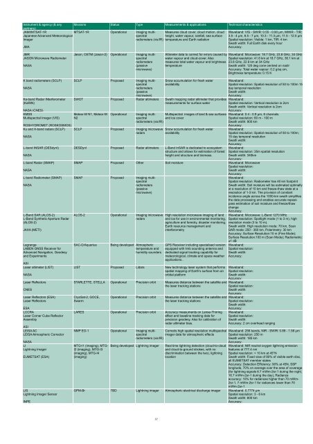
Instrument & agency (& any<br />
partners)<br />
JAMI/MTSAT-1R<br />
Japanese Advanced Meteorological<br />
Imager<br />
JMA<br />
Missions Status Type Measurements & applications Technical characteristics<br />
MTSAT-1R Operational Imaging multispectral<br />
radiometers (vis/IR)<br />
Measures cloud cover, cloud motion, cloud<br />
height, water vapour, rainfall, sea surface<br />
temparature and Earth radiation<br />
Waveband: VIS - SWIR: 0.55 - 0.90 µm, MWIR - TIR:<br />
3.5 - 4 µm, 6.5 - 7 µm, 10.3 - 11.3 µm, 11.5 - 12.5 µm<br />
Spatial resolution: Visible: 1 km, TIR: 4 km<br />
Swath width: Full Earth disk every hour<br />
Accuracy:<br />
JMR<br />
JASON Microwave Radiometer<br />
NASA<br />
Jason, OSTM (Jason-2) Operational Imaging multispectral<br />
radiometers<br />
(passive<br />
microwave)<br />
Altimeter data to correct for errors caused by<br />
water vapour and cloud-cover. Also<br />
measures total water vapour and brightness<br />
temperature<br />
Waveband: Microwave: 18.7 GHz, 23.8 GHz, 34 GHz<br />
Spatial resolution: 41.6 km at 18.7 GHz, 36.1 km at<br />
23.8 GHz, 22.9 km at 34 GHz<br />
Swath width: 120 deg cone centred on nadir<br />
Accuracy: Total water vapour: 0.2 g/sq cm,<br />
Brightness temperature: 0.15 K<br />
K band radiometers (SCLP)<br />
NASA<br />
Ka-band Radar INterferometer<br />
(KaRIN)<br />
NASA (CNES)<br />
KMSS<br />
Multispectral Imager (VIS)<br />
ROSHYDROMET (ROSKOSMOS)<br />
Ku and X-band radars (SCLP)<br />
NASA<br />
L-band INSAR (DESdynI)<br />
NASA<br />
L-band Radar (SMAP)<br />
NASA<br />
L-band Radiometer (SMAP)<br />
NASA<br />
L-Band SAR (ALOS-2)<br />
L-Band Syn<strong>the</strong>tic Aperture Radar<br />
(ALOS-2)<br />
JAXA (METI)<br />
Lagrange<br />
LABEN GNSS Receiver for<br />
Advanced Navigation, Geodesy<br />
and Experiments<br />
ASI<br />
Laser altimeter (LIST)<br />
NASA<br />
Laser Reflectors<br />
CNES<br />
Laser Reflectors (ESA)<br />
Laser Reflectors<br />
ESA<br />
LCCRA<br />
Laser Corner Cube Reflector<br />
Assembly<br />
ASI<br />
LEISA AC<br />
LEISA Atmospheric Corrector<br />
NASA<br />
LI<br />
Lightning Imager<br />
EUMETSAT (ESA)<br />
LIS<br />
Lightning Imager Sensor<br />
INPE<br />
SCLP Proposed Imaging multispectral<br />
radiometers<br />
(passive<br />
microwave)<br />
Snow accumulation for fresh water<br />
availability<br />
SWOT Proposed Radar altimeters Swath mapping radar altimeter that provides<br />
measurements for surface water<br />
Meteor-M N1, Meteor-M<br />
N2<br />
Operational<br />
SCLP Proposed Imaging microwave<br />
radars<br />
Imaging multispectral<br />
and ice cover<br />
Multispectral images of land & sea surfaces<br />
radiometers (vis/IR)<br />
Snow accumulation for fresh water<br />
availability<br />
DESDynI Proposed Radar altimeters L-Band InSAR is dedicated to ecosystem<br />
structure and allows for estimation of forest<br />
height and structure and biomass.<br />
Waveband:<br />
Spatial resolution: Spatial resolution of 50 to 100m 15<br />
day temporal resolution<br />
Swath width:<br />
Accuracy:<br />
Waveband:<br />
Spatial resolution: Vertical resolution is 2cm<br />
Swath width: Vertical resolution is 2cm<br />
Accuracy:<br />
Waveband: 0.4 - 0.9 µm, 6 channels<br />
Spatial resolution: 60 m - 100 m<br />
Swath width: 900 km<br />
Accuracy:<br />
SMAP Proposed O<strong>the</strong>r Soil moisture Waveband: Microwave<br />
Spatial resolution:<br />
Swath width:<br />
Accuracy:<br />
SMAP Proposed Imaging multispectral<br />
radiometers<br />
(passive<br />
microwave)<br />
ALOS-2 Operational Imaging microwave<br />
radars<br />
SAC-D/Aquarius<br />
Being developed Atmospheric<br />
temperature and<br />
humidity sounders<br />
High resolution microwave imaging of land<br />
and ice for use in environmental monitoring,<br />
agriculture and forestry, disaster monitoring,<br />
Earth resource management and<br />
interferometry<br />
GPS Receiver including specialised version<br />
equipped with limb sounding antenna and<br />
dedicated signal tracking capability for<br />
meteorological, climate and space wea<strong>the</strong>r<br />
applications..<br />
LIST Proposed Lidars New technology laser system that performs<br />
spatial mapping of Earth’s surface from an<br />
orbital platform<br />
STARLETTE, STELLA Operational Precision orbit Measures distance between <strong>the</strong> satellite and<br />
<strong>the</strong> laser tracking stations<br />
CryoSat-2, GOCE,<br />
Swarm<br />
Operational Precision orbit Measures distance between <strong>the</strong> satellite and<br />
<strong>the</strong> laser tracking stations<br />
LARES Operational Precision orbit Accuracy measuments on Lense-Thirring<br />
effect and baseline tracking data for<br />
precision geodesy. Also for calibration of<br />
radar altimeter bias.<br />
Waveband:<br />
Spatial resolution: Spatial resolution of 50 to 100m;<br />
15 day temporal resolution<br />
Swath width:<br />
Accuracy:<br />
Waveband:<br />
Spatial resolution: 35m spatial resolution<br />
Swath width: 340km<br />
Accuracy:<br />
Waveband:<br />
Spatial resolution: Radiometer has 40 km footprint<br />
Swath width: Soil moisture will be estimated optimally<br />
at a resolution of 10 km and freeze-thaw state at a<br />
resolution of 1-3 km. The provision of constant<br />
incidence angle across <strong>the</strong> 1000-km swath simplifies<br />
<strong>the</strong> data processing and enables accurate repeatpass<br />
estimation of soil moisture and freeze/thaw<br />
change<br />
Accuracy:<br />
Waveband: Microwave: L-Band 1270 MHz<br />
Spatial resolution: Spotlight mode (1 to 3 m), high<br />
resolution mode (3 to 10 m).<br />
Swath width: High resolution mode: 70 km, Scan<br />
SAR mode: 250 - 360 km, Polarimetry: 30 km<br />
Accuracy: Surface Resolution:10 m (Fine Mode);<br />
Surface Resolution:100 m (Scan Mode); Radiometric:<br />
±1 dB<br />
Waveband:<br />
Spatial resolution:<br />
Swath width:<br />
Accuracy:<br />
Waveband:<br />
Spatial resolution:<br />
Swath width:<br />
Accuracy:<br />
Waveband:<br />
Spatial resolution:<br />
Swath width:<br />
Accuracy:<br />
Waveband:<br />
Spatial resolution:<br />
Swath width:<br />
Accuracy:<br />
Waveband:<br />
Spatial resolution:<br />
Swath width:<br />
Accuracy: 2 cm overhead ranging<br />
NMP EO-1 Operational Imaging multispectral<br />
Corrects high spatial resolution multispectral Waveband: 256 bands, NIR - SWIR: 0.89 - 1.58 µm<br />
radiometers (vis/IR)<br />
imager data for atmospheric effects Spatial resolution: 250 m<br />
Swath width: 185 km<br />
Accuracy:<br />
MTG-I1 (imaging), MTG-<br />
I2 (imaging), MTG-I3<br />
(imaging), MTG-I4<br />
(imaging)<br />
Being developed Lightning imager<br />
Real time lightning detection (cloud-to-cloud<br />
and cloud-to-ground strokes, with no<br />
discrimination between <strong>the</strong> two), lightning<br />
location<br />
Waveband: NIR neutral oxygen ligthning emission<br />
features at 777.4 nm<br />
Spatial resolution: < 10 km at 45°N<br />
Swath width: Fixed view of 80% of visible <strong>earth</strong> disc,<br />
all EUMETSAT member states<br />
Accuracy: Detection Efficiency: 90% at 45N, SSP<br />
longitude, 70% on average over <strong>the</strong> area of coverage<br />
(for lightning signals 6.7 mWm-2sr-1 during <strong>the</strong> night,<br />
16.7 mWm-2sr-1 during <strong>the</strong> day), Radiance<br />
accuracy: 10% for radiances higher than 70 mWm-<br />
2sr-1, 7 mWm-2sr-1 for radiances lower than 70<br />
mWm-2sr-1<br />
GPM-Br TBD Lightning imager Atmospheric electrical discharge imager Waveband: 0.7774 µm<br />
Spatial resolution: 3 - 6 km<br />
Swath width: 600 km<br />
Accuracy:<br />
37


