

the earth observation handbook
The Earth Observation Handbook - Key Tables - SEOCA
The Earth Observation Handbook - Key Tables - SEOCA
- No tags were found...

Create successful ePaper yourself
Turn your PDF publications into a flip-book with our unique Google optimized e-Paper software.
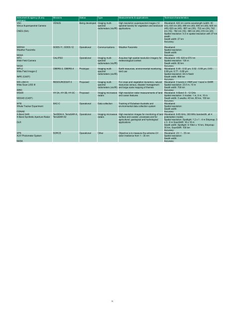
Instrument & agency (& any<br />
partners)<br />
VSC<br />
Venus Superspectral Camera<br />
CNES (ISA)<br />
WEFAX<br />
Wea<strong>the</strong>r Facsimile<br />
NOAA<br />
WFC<br />
Wide Field Camera<br />
NASA<br />
WFI-2<br />
Wide Field Imager-2<br />
INPE (CAST)<br />
WS LISS III<br />
Wide Scan LISS III<br />
ISRO<br />
WSAR<br />
NSOAS (CAST)<br />
WTE<br />
Whale Tracker Experiment<br />
CONAE<br />
X-Band SAR<br />
X-Band Syn<strong>the</strong>tic Aperture Radar<br />
DLR<br />
XPS<br />
XUV Photometer System<br />
NASA<br />
Missions Status Type Measurements & applications Technical characteristics<br />
VENUS<br />
Being developed Imaging multispectral<br />
spectral bands) for vegetation and landcover nm); 443 nm (40); 490 nm (40); 555 nm (40); 620 nm<br />
High resolution superspectral images (12 Waveband: 420 nm centre wavelength (width: 40<br />
radiometers (vis/IR) applications<br />
(40); 620 nm (40); 667 nm (30); 702 nm (24); 742<br />
nm (16); 782 nm (16); 865 nm (40); 910 nm (20)<br />
Spatial resolution: 5.3 m spatial resolution with 27 km<br />
swath<br />
Swath width: 27 km<br />
Accuracy:<br />
GOES-11, GOES-12 Operational Communications Wea<strong>the</strong>r Facsimile Waveband:<br />
Spatial resolution:<br />
Swath width:<br />
Accuracy:<br />
CALIPSO Operational Imaging multispectral<br />
Acquires high spatial resolution imagery for<br />
meteorological context<br />
radiometers (vis/IR)<br />
CBERS-3, CBERS-4 Prototype Imaging multispectral<br />
Earth resources, environmental monitoring,<br />
land use<br />
radiometers (vis/IR)<br />
RESOURCESAT-3 Proposed Imaging multispectral<br />
radiometers (vis/IR)<br />
HY-3A, HY-3B, HY-3C Proposed Imaging microwave<br />
radars<br />
For crops and vegetation dynamics, natural<br />
resources census, disaster management<br />
and large scale mapping of <strong>the</strong>mes<br />
High resolution radar measurements of land<br />
and ocean features<br />
SAC-C Operational Data collection Tracking of Eubalean Australis and<br />
environmental data collection system<br />
TanDEM-X, TerraSAR-X,<br />
TerraSAR-X2<br />
Operational<br />
Imaging microwave<br />
radars<br />
High resolution images for monitoring of land<br />
surface and coastal processes and for<br />
agricultural, geological and hydrological<br />
applications<br />
SORCE Operational O<strong>the</strong>r Objective is to measure <strong>the</strong> extreme UV<br />
solar irradiance from 1 - 35 nm<br />
Waveband: VIS: 620 to 670 nm<br />
Spatial resolution: 125 m<br />
Swath width: 60 km<br />
Accuracy:<br />
Waveband: 0.45 - 0.52 µm, 0.52 - 0.59 µm, 0.63 -<br />
0.69 µm; 0.77 - 0.89 µm<br />
Spatial resolution: 64 m Nadir<br />
Swath width: 866 km<br />
Accuracy:<br />
Waveband: 3 bands in VNIR and 1 band in SWIR<br />
Spatial resolution: 23.5 m, 10 m<br />
Swath width: 700 km<br />
Accuracy:<br />
Waveband: X-Band: 8 - 12 GHz<br />
Spatial resolution: 3 modes: 1 m, 5 m, 10 m<br />
Swath width: 3 swaths: 40 km, 80 km, 150 km<br />
Accuracy:<br />
Waveband:<br />
Spatial resolution:<br />
Swath width:<br />
Accuracy:<br />
Waveband: 9.65 GHz, 300 MHz bandwidth, all 4<br />
polarisation modes<br />
Spatial resolution: Spotlight: 1.2 x 1 - 4 m Stripmap: 3<br />
x 3 - 6 m ScanSAR: 16 x 16 m<br />
Swath width: Spotlight: 5-10km x 10 km, Stripmap:<br />
30 km, ScanSAR: 100 km<br />
Accuracy:<br />
Waveband: UV: 1 - 35 nm<br />
Spatial resolution:<br />
Swath width:<br />
Accuracy:<br />
51


