

the earth observation handbook
The Earth Observation Handbook - Key Tables - SEOCA
The Earth Observation Handbook - Key Tables - SEOCA
- No tags were found...

Create successful ePaper yourself
Turn your PDF publications into a flip-book with our unique Google optimized e-Paper software.
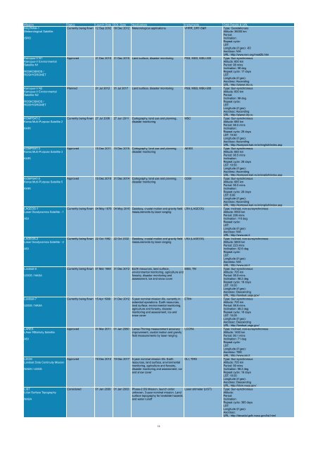
Mission Status Launch Date EOL Date Applications Instruments Orbit Details & URL<br />
KALPANA-1<br />
Meteorological Satellite<br />
ISRO<br />
Currently being flown 12 Sep 2002 09 Dec 2012 Meteorological applications VHRR, DRT-S&R Type: Geostationary<br />
Altitude: 36000 km<br />
Period:<br />
Inclination:<br />
Repeat cycle:<br />
LST:<br />
Longitude (if geo): -83<br />
Asc/desc: N/A<br />
URL: http://www.isro.org/insat2b.htm<br />
Kanopus-V N1<br />
Kanopus-V Environmental<br />
Satellite N1<br />
ROSKOSMOS /<br />
ROSHYDROMET<br />
Kanopus-V N2<br />
Kanopus-V Environmental<br />
Satellite N2<br />
ROSKOSMOS /<br />
ROSHYDROMET<br />
KOMPSAT-2<br />
Korea Multi-Purpose Satellite 2<br />
KARI<br />
KOMPSAT-3<br />
Korea Multi-Purpose Satellite 3<br />
KARI<br />
KOMPSAT-5<br />
Korea Multi-Purpose Satellite 5<br />
KARI<br />
LAGEOS-1<br />
Laser Geodynamics Satellite - 1<br />
ASI<br />
LAGEOS-2<br />
Laser Geodynamics Satellite - 2<br />
ASI<br />
Landsat-5<br />
USGS / NASA<br />
Landsat-7<br />
USGS / NASA<br />
LARES<br />
LAser RElativity Satellite<br />
ASI<br />
LDCM<br />
Landsat Data Continuity Mission<br />
NASA / USGS<br />
LIST<br />
Lidar Surface Topography<br />
NASA<br />
Approved 31 Dec 2010 31 Dec 2015 Land surface, disaster monitoring PSS, MSS, MSU-200 Type: Sun-synchronous<br />
Altitude: 600 km<br />
Period: 98 mins<br />
Inclination: 98 deg<br />
Repeat cycle: 17 days<br />
LST:<br />
Longitude (if geo):<br />
Asc/desc: Ascending<br />
URL: http://planet.iitp.ru<br />
Planned 31 Jul 2012 31 Jul 2017 Land surface, disaster monitoring PSS, MSS, MSU-200 Type: Sun-synchronous<br />
Altitude: 600 km<br />
Period:<br />
Inclination: 98 deg<br />
Repeat cycle:<br />
LST:<br />
Longitude (if geo):<br />
Asc/desc: Ascending<br />
URL: http://planet.iitp.ru<br />
Currently being flown 27 Jul 2006 27 Jun 2011 Cartography, land use and planning,<br />
disaster monitoring<br />
Approved 15 Dec 2011 15 Dec 2015 Cartography, land use and planning,<br />
disaster monitoring<br />
Approved 15 Dec 2010 31 Dec 2014 Cartography, land use and planning,<br />
disaster monitoring<br />
Currently being flown 04 May 1976 04 May 2016 Geodesy, crustal motion and gravity field<br />
measurements by laser ranging<br />
Currently being flown 22 Oct 1992 22 Oct 2032 Geodesy, crustal motion and gravity field<br />
measurements by laser ranging<br />
MSC<br />
AEISS<br />
COSI<br />
LRA (LAGEOS)<br />
LRA (LAGEOS)<br />
Currently being flown 01 Mar 1984 31 Dec 2012 Earth resources, land surface,<br />
environmental monitoring, agriculture and<br />
forestry, disaster monitoring and<br />
assessment, ice and snow cover<br />
MSS, TM<br />
Currently being flown 15 Apr 1999 31 Dec 2012 5-year nominal mission life, currently in<br />
extended operations. Earth resources,<br />
land surface, environmental monitoring,<br />
agriculture and forestry, disaster<br />
monitoring and assessment, ice and<br />
snow cover<br />
Approved 31 Mar 2011 01 Jan 2050 Lense-Thirring measurement accuracy<br />
improvement, crustal motion and gravity<br />
field measurements by laser ranging<br />
Approved 19 Dec 2012 19 Dec 2017 5-year nominal mission life. Earth<br />
resources, land surface, environmental<br />
monitoring, agriculture and forestry,<br />
disaster monitoring and assessment, ice<br />
and snow cover<br />
ETM+<br />
LCCRA<br />
OLI, TIRS<br />
Considered 01 Jan 2030 01 Jan 2033 Phase-2 DS Mission, launch order<br />
unknown, 3-year nominal mission. Land<br />
surface topography for landslide hazards<br />
and water runoff<br />
Laser altimeter (LIST)<br />
Type: Sun-synchronous<br />
Altitude: 685 km<br />
Period: 98.5 mins<br />
Inclination:<br />
Repeat cycle: 28 days<br />
LST: 10:50<br />
Longitude (if geo):<br />
Asc/desc: Ascending<br />
URL: http://kompsat.kari.re.kr/english/index.asp<br />
Type: Sun-synchronous<br />
Altitude: 685 km<br />
Period: 98.5 mins<br />
Inclination:<br />
Repeat cycle: 28 days<br />
LST: 10:50<br />
Longitude (if geo):<br />
Asc/desc: Ascending<br />
URL: http://kompsat.kari.re.kr/english/index.asp<br />
Type: Sun-synchronous<br />
Altitude: 685 km<br />
Period: 98.5 mins<br />
Inclination:<br />
Repeat cycle: 28 days<br />
LST: 6:00<br />
Longitude (if geo):<br />
Asc/desc: Ascending<br />
URL: http://kompsat.kari.re.kr/english/index.asp<br />
Type: Inclined, non-sunsynchronous<br />
Altitude: 5900 km<br />
Period: 226 mins<br />
Inclination: 110 deg<br />
Repeat cycle:<br />
LST:<br />
Longitude (if geo):<br />
Asc/desc: N/A<br />
URL: http://www.asi.it<br />
Type: Inclined, non-sunsynchronous<br />
Altitude: 5800 km<br />
Period: 223 mins<br />
Inclination: 52.6 deg<br />
Repeat cycle:<br />
LST:<br />
Longitude (if geo):<br />
Asc/desc: N/A<br />
URL: http://www.asi.it<br />
Type: Sun-synchronous<br />
Altitude: 705 km<br />
Period: 98.9 mins<br />
Inclination: 98.2 deg<br />
Repeat cycle: 16 days<br />
LST: 10:00<br />
Longitude (if geo):<br />
Asc/desc: Descending<br />
URL: http://landsat.usgs.gov/<br />
Type: Sun-synchronous<br />
Altitude: 705 km<br />
Period: 98.9 mins<br />
Inclination: 98.2 deg<br />
Repeat cycle: 16 days<br />
LST: 10:05<br />
Longitude (if geo):<br />
Asc/desc: Descending<br />
URL: http://landsat.usgs.gov/<br />
Type: Inclined, non-sunsynchronous<br />
Altitude: 1450 km<br />
Period: 99.1 mins<br />
Inclination: 71 deg<br />
Repeat cycle:<br />
LST:<br />
Longitude (if geo):<br />
Asc/desc: TBD<br />
URL: http://www.asi.it<br />
Type: Sun-synchronous<br />
Altitude: 705 km<br />
Period: 99 mins<br />
Inclination: 98.2 deg<br />
Repeat cycle: 16 days<br />
LST: 10:00<br />
Longitude (if geo):<br />
Asc/desc: Descending<br />
URL: http://ldcm.nasa.gov/<br />
Type: Sun-synchronous<br />
Altitude:<br />
Period:<br />
Inclination:<br />
Repeat cycle: 365 days<br />
LST:<br />
Longitude (if geo):<br />
Asc/desc:<br />
URL: http://decadal.gsfc.nasa.gov/list.html<br />
14


