

TUZLU SU SALTWATER
14B_Catalogue
14B_Catalogue
- No tags were found...

Create successful ePaper yourself
Turn your PDF publications into a flip-book with our unique Google optimized e-Paper software.
112 Jeffrey Peakall<br />
Denemeler / Essays<br />
113<br />
Jeffrey Peakall<br />
Underwater Rivers: From the Bosphorus<br />
to Ocean Floors<br />
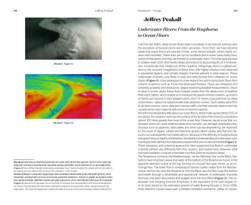
(Resim 1 / Figure 1)<br />
(Resim 2 / Figure 2)<br />
(Resim 1) Laboratuvar ortamında yaratılmış bir sualtı nehir akımından görüntü. Akımın yönü izleyiciye<br />
doğrudur ve kanalın kenarlarından taşmakta olduğu görülebilir. Kanal yaklaşık 20 cm genişliğindedir.<br />
(Figure 1) View of flow through a laboratory underwater river. Flow is towards the viewer, and can be seen to<br />
be spilling over the sides of the channel. The channel is ~20 cm wide.<br />
(Resim 2) Boğaz’ın çıkışından aşağı doğru akan, Karadeniz tabanındaki sualtı nehrinden görüntü. Akım<br />
izleyenden uzaklaşmakta, turuncu ve kırmızılar yükselme noktalarını, maviler ve yeşiller ise alçalma noktalarını<br />
göstermektedir. Şekildeki kanalın genişliği maksimum 1,3 km, derinliği de maksimum 25 m kadardır.<br />
(Figure 2) View of the underwater river on the floor of the Black Sea, downstream from the exit of the Bosphorus.<br />
Flow is moving away from the viewer, and blues and greens are low points, whilst oranges and reds are<br />
high points. The channel imaged has a maximum width of around 1.3 km and a maximum depth of about 25 m.<br />
Until the late 1940s, deep-ocean floors were considered to be smooth surfaces with<br />
the exception of fracture-zones and relict volcanoes. Since then, we have become<br />
aware that ocean floors are covered in lines, some almost straight, others highly sinuous<br />
and contorted. These lines can run for hundreds and in some cases many thousands<br />
of kilometres, and they are formed by underwater rivers. The lines typically start<br />
in shallow water (200–300 metres deep) and extend to abyssal depths of 4–5 kilometres;<br />
occasionally they initiate just off the coastline. Intriguingly, there is a global variation<br />
in the sinuosity (wiggliness) of these lines, with highly tortuous ones observed<br />
in equatorial regions, and virtually straight channels present in polar regions. These<br />
underwater channels carry flows of mud and sand formed from collapses on ocean<br />
slopes (Figure 1), close analogues to snow avalanches and to pyroclastic flows from<br />
volcanic eruptions such as those that destroyed Pompeii. Flows are infrequent and<br />
extremely powerful and destructive, largely restricting detailed measurements. Much<br />
of what is known about these flows instead comes from the destruction of seafloor<br />
fibre-optic cables, which enable us to measure the speed of these currents, up to tens<br />
of metres per second in their steepest parts, and 7–8 metres a second even on deep<br />
ocean floors – about the speed of elite male distance runners. Such cables carry 95%<br />
of all trans-oceanic voice, data and internet traffic and their periodic destruction has<br />
caused some major regional reductions in internet capacity.<br />
We still know remarkably little about our ocean floors, which make up two thirds (71%) of<br />
our planet. For instance, we know the surface of the far side of the moon to a resolution<br />
almost 100 times greater than most of the ocean floor. However, we do know that: underwater<br />
rivers can cause small but destructive tsunami; can damage underwater infrastructure<br />
such as pipelines, data cables and other sub-sea engineering; are important<br />
for the burial of organic carbon and therefore global carbon cycles; and that their deposits<br />
can subsequently host hydrocarbons. Because of the difficulty of studying these<br />
infrequent flows at depths of kilometres, the detailed understanding of underwater rivers<br />
has largely been derived from laboratory experiments and numerical models (Figure 1).<br />
These laboratory and numerical approaches have suggested that flows in underwater<br />
channels behave very differently from their cousins, land-based rivers. However, what<br />
has been needed is a natural underwater river that could be studied in detail.<br />
The Bosphorus connects the Mediterranean, via the Marmara Sea, to the Black Sea.<br />
Sailors have long been aware that water at the bottom of the Bosphorus moves in the<br />
opposite direction to that at the top, forming an unusual flow type known as an exchange<br />
flow. The lower flow is composed of denser (saltier) water from the Mediterranean<br />
and as this exits the Bosphorus into the Black Sea the flow hugs the bottom<br />
and travels through a remarkable and spectacular network of underwater channels<br />
that have only been discovered and imaged since the mid-1990s (Figure 2). The underwater<br />
river initiating from the Bosphorus is the equivalent of the sixth largest river<br />
on land, based on the estimated amount of water flowing through it. Since 2008,<br />
three research cruises have used a remote-controlled submarine, yellow of course,