FM 3-34.22 - Army Electronic Publications & Forms - U.S. Army
FM 3-34.22 - Army Electronic Publications & Forms - U.S. Army
FM 3-34.22 - Army Electronic Publications & Forms - U.S. Army

You also want an ePaper? Increase the reach of your titles
YUMPU automatically turns print PDFs into web optimized ePapers that Google loves.
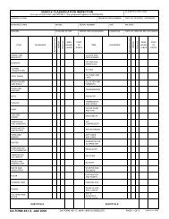
Appendix E<br />
CROSSING-SITE COMMANDER<br />
E-25. Each crossing site has an engineer, typically a company commander or a platoon leader, who<br />
handles the crossing of the units sent to the site. Normally, the crossing-site commander (CSC) is the<br />
company commander for the bridge unit operating the site. He commands the engineers operating the<br />
crossing means and the engineer regulating points (ERPs) at the call-forward areas for that site. He<br />
maintains the site and decides on the immediate action needed to remove broken-down or damaged<br />
vehicles that interfere with activities at the site. The CSC is responsible to the CAE and keeps him<br />
informed on the status of the site.<br />
UNIT MOVEMENT CONTROL OFFICER<br />
E-26. Each battalion or separate unit commander designates a movement control officer who coordinates<br />
unit movement according to the movement control plan. He provides staff planners with detailed<br />
information on unit vehicle types and quantities.<br />
CONTROL MECHANISMS<br />
E-27. A major control mechanism category is graphic control measures. The commander uses the<br />
following graphic control measures (see figure E-5) to delineate AORs for subordinates and to ease traffic<br />
control:<br />
� RLs. RLs are used to delineate the crossing area. RLs are located on the farside and the<br />
nearside, within 3 to 4 kilometers of the gap, and indicate a change in the headquarters that is<br />
controlling movements. Typically, they are graphically identified as PLs and located on easily<br />
identifiable terrain when possible.<br />
� Crossing areas. Crossing areas are normally brigade-size, controlled-access areas for<br />
gap-crossing operations that are designed to decrease traffic congestion at the gap. They<br />
normally extend 3 to 4 kilometers on each side of the gap, are METT-TC-dependent, and are<br />
defined by BCT boundaries and RLs.<br />
Figure E-5. Graphic control measures<br />
E-10 <strong>FM</strong> 3-<strong>34.22</strong> 11 February 2009