guida per la redazione delle parcelle - Ordine dei Geologi del Lazio
guida per la redazione delle parcelle - Ordine dei Geologi del Lazio
guida per la redazione delle parcelle - Ordine dei Geologi del Lazio

Create successful ePaper yourself
Turn your PDF publications into a flip-book with our unique Google optimized e-Paper software.
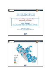
ORDINE DEI GEOLOGI DEL LAZIO<br />
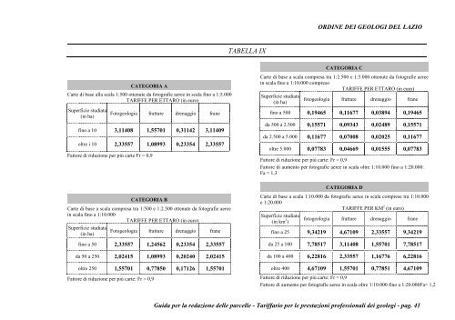
TABELLA IX<br />
CATEGORIA C<br />
CATEGORIA A<br />
Carte di base al<strong>la</strong> sca<strong>la</strong> 1:500 ottenute da fotografie aeree in sca<strong>la</strong> fino a 1:5.000<br />
TARIFFE PER ETTARO (in euro)<br />
Su<strong>per</strong>ficie studiata<br />
(in ha)<br />
Fotogeologia fratture drenaggio frane<br />
fino a 10 3,11408 1,55701 0,31142 3,11409<br />
oltre i 10 2,33557 1,08993 0,23354 2,33557<br />
Fattore di riduzione <strong>per</strong> più carte Fr = 0,9<br />
Carte di base a sca<strong>la</strong> compresa tra 1:2.500 e 1:5.000 ottenute da fotografie aeree<br />
in sca<strong>la</strong> fino a 1:10.000 compreso<br />
TARIFFE PER ETTARO (in euro)<br />
Su<strong>per</strong>ficie studiata<br />
fotogeologia fratture drenaggio frane<br />
(in ha)<br />
fino a 500 0,19465 0,11677 0,03894 0,19465<br />
da 500 a 2.500 0,15571 0,09343 0,02489 0,15571<br />
da 2.500 a 5.000 0,11677 0,07008 0,02025 0,11677<br />
oltre 5.000 0,07783 0,04669 0,01555 0,07783<br />
Fattore di riduzione <strong>per</strong> più carte: Fr = 0,9<br />
Fattore di aumento <strong>per</strong> fotografie aeree in sca<strong>la</strong> oltre 1:10.000 fino a 1:20.000:<br />
Fa = 1,3<br />
CATEGORIA D<br />
CATEGORIA B<br />
Carte di base a sca<strong>la</strong> compresa tra 1:500 e 1:2.500 ottenute da fotografie aeree<br />
in sca<strong>la</strong> fino a 1:10.000<br />
TARIFFE PER ETTARO (in euro)<br />
Su<strong>per</strong>ficie studiata<br />
Fotogeologia fratture drenaggio frane<br />
(in ha)<br />
fino a 50 2,33557 1,24562 0,23354 2,33557<br />
da 50 a 250 2,02415 1,08993 0,20240 2,02415<br />
oltre 250 1,55701 0,77850 0,17126 1,55701<br />
Fattore di riduzione <strong>per</strong> più carte: Fr = 0,9<br />
Carte di base a sca<strong>la</strong> 1:10.000 da fotografie aeree in sca<strong>la</strong> comprese tra 1:10.000<br />
e 1:20.000<br />
TARIFFE PER KM 2 (in euro)<br />
Su<strong>per</strong>ficie studiata<br />
(in km 2 fotogeologia fratture drenaggio frane<br />
)<br />
fino a 25 9,34219 4,67109 2,33557 9,34219<br />
da 25 a 100 7,78517 3,11408 1,55701 7,78517<br />
da 100 a 400 6,22816 2,33557 1,16776 6,22816<br />
oltre 400 4,67109 1,55701 0,77851 4,67109<br />
Fattore di riduzione <strong>per</strong> più carte: Fr = 0,9<br />
Fattore di aumento <strong>per</strong> fotografie aeree in sca<strong>la</strong> oltre 1:10.000 fino a 1:20.000Fa= 1,2<br />
Guida <strong>per</strong> <strong>la</strong> <strong>redazione</strong> <strong><strong>del</strong>le</strong> <strong>parcelle</strong> - Tariffario <strong>per</strong> le prestazioni professionali <strong>dei</strong> geologi - pag. 41