guida per la redazione delle parcelle - Ordine dei Geologi del Lazio
guida per la redazione delle parcelle - Ordine dei Geologi del Lazio
guida per la redazione delle parcelle - Ordine dei Geologi del Lazio

You also want an ePaper? Increase the reach of your titles
YUMPU automatically turns print PDFs into web optimized ePapers that Google loves.
ORDINE DEI GEOLOGI DEL LAZIO<br />
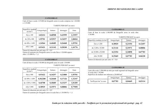
CATEGORIA E<br />
Carte di base a sca<strong>la</strong> 1:25.000 da fotografie aeree in sca<strong>la</strong> comprese tra 1:20.000<br />
e 1:35.000<br />
TARIFFE PER KM 2 (in euro)<br />
Su<strong>per</strong>ficie studiata<br />
(in km 2 )<br />
Fotogeologia fratture drenaggio frane<br />
fino a 100 2,02414 0,68508 0,43599 2,33557<br />
da 100 a 400 1,55701 0,52937 0,34257 1,86844<br />
da 400 a 1.600 1,24564 0,40485 0,26468 1,55701<br />
oltre 1.600 0,93421 0,31142 0,20240 1,16776<br />
Fattore di riduzione <strong>per</strong> più carte: Fr = 0,9<br />
Fattore di aumento <strong>per</strong> fotografie aeree in sca<strong>la</strong> fino a 1:20.000 oppure<br />
oltre 1:35.000 Fa = 1,1<br />
CATEGORIA F<br />
Carte di base in sca<strong>la</strong> 1:50.000 da fotografie aeree in sca<strong>la</strong> 1:30.000<br />
TARIFFE PER KM 2 (in euro)<br />
Su<strong>per</strong>ficie studiata<br />
(in km 2 )<br />
Fotogeologia fratture drenaggio frane<br />
fino a 400 0,93422 0,34257 0,21800 1,55701<br />
da 400 a 1.600 0,562280 0,26468 0,17126 1,32347<br />
da 1.600 a 5.000 0,46708 0,18685 0,13237 1,01205<br />
CATEGORIA G<br />
Carte di base in sca<strong>la</strong> 1:100.000 da fotografie aeree in sca<strong>la</strong> oltre<br />
1:30.000<br />
TARIFFE PER KM 2 (in euro)<br />
Su<strong>per</strong>ficie studiata (in km 2 ) fotogeologia fratture drenaggio<br />
fino a 3.200 0,38925 0,23354 0,12457<br />
da 3.200 a 10.000 0,31142 0,15571 0,08806<br />
da 10.000 a 30.000 0,23354 0,10898 0,07783<br />
oltre 30.000 0,19465 0,07783 0,06228<br />
Fattore di riduzione <strong>per</strong> più carte: Fr = 0,9<br />
CATEGORIA H<br />
Carte al<strong>la</strong> sca<strong>la</strong> 1:200.000 ed oltre <strong>per</strong> studi regionali da fotografie aeree<br />
in sca<strong>la</strong> oltre 1:30.000<br />
Su<strong>per</strong>ficie da studiare non inferiore a 20.000 km 2<br />
fotogeologia fratture drenaggio<br />
Tariffa <strong>per</strong> km 2 in euro 0,07783 0,04669 0,03114<br />
oltre 5.000 0,38925 0,15571 0,08806 0,77850<br />
Fattore di riduzione <strong>per</strong> più carte: Fr = 0,9<br />
Fattore di aumento <strong>per</strong> fotografie aeree in sca<strong>la</strong> fino a 1:30.000 Fa = 1,1<br />
Guida <strong>per</strong> <strong>la</strong> <strong>redazione</strong> <strong><strong>del</strong>le</strong> <strong>parcelle</strong> - Tariffario <strong>per</strong> le prestazioni professionali <strong>dei</strong> geologi - pag. 42