download pdf - Institut für Umweltphysik - Ruprecht-Karls-Universität ...
download pdf - Institut für Umweltphysik - Ruprecht-Karls-Universität ...
download pdf - Institut für Umweltphysik - Ruprecht-Karls-Universität ...

Create successful ePaper yourself
Turn your PDF publications into a flip-book with our unique Google optimized e-Paper software.
2.5. SATELLITE GROUP 69<br />
2.5 Satellite Group<br />
Participating scientist Steffen Beirle, Tim Deutschmann, Barbara Dix, Ossama Ibrahim, Christian<br />
Frankenberg, Michael Grzegorski, Klaus-Peter Heue, Jens Hollwedel, Muhammad Fahim Khokhar,<br />
Sven Kühl, Thiery Marbach, Janis Pukite, Suniti Sanghavi, Thomas Wagner, and Walburga Wilms-<br />
Grabe<br />
Abstract The Satellitegroup is part of the researchgroup Atmospheric Physics of Prof. Dr. Ulrich<br />
Platt. The satellite born remote sensing of the Earth’s atmosphere at the University of Heidelberg<br />
started in 1996 with the retrieval of atmospheric trace gases, namely NO2 and BrO. Today a wide variety<br />
of trace gases and other atmospheric parameters (Aerosols, Clouds, Radiative Transfer) from different<br />
satellite instruments are investigated at the IUP (see also http://satellite.iup.uni-heidelberg.de).<br />
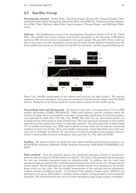
Figure 2.34: Satellite measurement of the reflected and scattered sun light (yellow). The spectral<br />
signatures of several atmospheric trace gases are analysed in selected spectral ranges using the DOAS<br />
method. Displayed are the fitting results for various species analysed in the satellite group.<br />
Overarching topic and Background For about 10 years now, a new generation of UV/vis/NIR<br />
satellite instruments (GOME, SCIAMACHY, OMI) with moderate spectral resolution allows the<br />
retrieval of a large variety of atmospheric trace gases. In particular, global maps of several tropospheric<br />
trace gases like O3, BrO, NO2, CO, CH4, CO2, HCHO, SO2, H2O, O2, O4, and cloud properties can<br />
be analysed from observations in nadir viewing mode. The most important advantage of such satellite<br />
observations is their spatial (horizontal) coverage and resolution. The latest generation of nadir looking<br />
UV/vis satellite instruments (e.g. OMI) achieves global coverage within one day and has a horizontal<br />
resolution of about 13 x 24 km 2 . From such satellite observations, various individual sources like large<br />
cities can be identified. In addition, the observation of scattered sun light in limb geometry allows to<br />
retrieve vertical profiles of several stratospheric trace gases like O3, NO2, BrO and OClO.<br />
Funding The group activities are funded through various national and international projects, e.g.<br />
SCIAMACHY validation, FORMAT, STAR, Tropische Tropopause, NOXTRAM, EVERGREEN, AC-<br />
CENT<br />
Main methods From the measured spectra, the narowband absorption features of several trace<br />
gases are analysed using the DOAS method (see Figure). The result of the spectral analysis represents<br />
the trace gas absorption integrated along the absorption path. In addition, also the broad band<br />
spectral features are analysed; they yield information in particular on the cloud cover, aerosol load and<br />
ground albedo. Various algorithms for the analysis of satellite spectra were developed in the satellite<br />
group within the last years. For the detailed interpretation of the analysed spectral information,<br />
radiative transfer modelling is needed. A 3-D Monte-Carlo radiative transfer model (TRACY) was<br />
developed in our group, which allows to simulate various complex viewing geometries and atmospheric<br />
properties. The retrieved global data sets are further investigated using image sequence techniques.