

Chapters 1 - U.S. Fish and Wildlife Service
Chapters 1 - U.S. Fish and Wildlife Service
Chapters 1 - U.S. Fish and Wildlife Service

Create successful ePaper yourself
Turn your PDF publications into a flip-book with our unique Google optimized e-Paper software.
Chapter 5 <br />
sea level rise in the general vicinity of the Refuge; the approximate tidal range at the site; salt<br />
marsh accretion rates; <strong>and</strong> the assumption that all of the Refuge’s tidally influenced habitats have<br />
unrestricted tidal flow (Clough <strong>and</strong> Larson 2008). The historic trend for sea level rise in the<br />
general vicinity of the Refuge was estimated at 1.5 mm/year (0.059 inches/year) using the average<br />
of the three closest stations (9410660, Los Angeles California; 9410580, Newport Beach California;<br />
9410840, Santa Monica California). There are no long-term sea level trend data available for the<br />
gage at Long Beach CA. The measured rate at this location is roughly equal to the global average<br />
for the last 100 years.<br />
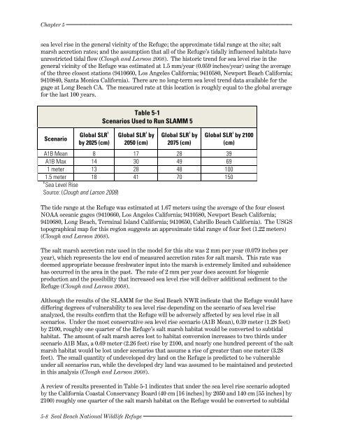
Scenario<br />
Global SLR 1<br />
by 2025 (cm)<br />
Table 5-1<br />
Scenarios Used to Run SLAMM 5<br />
Global SLR 1 by<br />
2050 (cm)<br />
Global SLR 1 by<br />
2075 (cm)<br />
Global SLR 1 by 2100<br />
(cm)<br />
A1B Mean 8 17 28 39<br />
A1B Max 14 30 49 69<br />
1 meter 13 28 48 100<br />
1.5 meter<br />
1<br />
Sea Level Rise<br />
18 41 70 150<br />
Source: (Clough <strong>and</strong> Larson 2008)<br />
The tide range at the Refuge was estimated at 1.67 meters using the average of the four closest<br />
NOAA oceanic gages (9410660, Los Angeles California; 9410580, Newport Beach California;<br />
9410680, Long Beach, Terminal Isl<strong>and</strong> California; 9410650, Cabrillo Beach California). The USGS<br />
topographical map for this region suggests an approximate tidal range of four feet (1.22 meters)<br />
(Clough <strong>and</strong> Larson 2008).<br />
The salt marsh accretion rate used in the model for this site was 2 mm per year (0.079 inches per<br />
year), which represents the low end of measured accretion rates for salt marsh. This rate was<br />
deemed appropriate because freshwater input into the marsh is extremely limited <strong>and</strong> subsidence<br />
has occurred in the area in the past. The rate of 2 mm per year does account for biogenic<br />
production <strong>and</strong> the possibility that increased sea level rise will deliver additional sediment to the<br />
Refuge (Clough <strong>and</strong> Larson 2008).<br />
Although the results of the SLAMM for the Seal Beach NWR indicate that the Refuge would have<br />
differing degrees of vulnerability to sea level rise depending on the scenario of sea level rise<br />
analyzed, the results confirm that the Refuge will be adversely affected by sea level rise in all<br />
scenarios. Under the most conservative sea level rise scenario (A1B Mean), 0.39 meter (1.28 feet)<br />
by 2100, roughly one quarter of the Refuge’s salt marsh habitat would be converted to subtidal<br />
habitat. The amount of salt marsh acres lost to habitat conversion increases to two thirds under<br />
scenario A1B Max, a 0.69 meter (2.26 feet) rise by 2100, <strong>and</strong> nearly one hundred percent of the salt<br />
marsh habitat would be lost under scenarios that assume a rise of greater than one meter (3.28<br />
feet). The small quantity of undeveloped dry l<strong>and</strong> on the Refuge is predicted to be vulnerable<br />
under all scenarios run, while the developed dry l<strong>and</strong> was assumed to be maintained <strong>and</strong> protected<br />
in this analysis (Clough <strong>and</strong> Larson 2008).<br />
A review of results presented in Table 5-1 indicates that under the sea level rise scenario adopted<br />
by the California Coastal Conservancy Board (40 cm [16 inches] by 2050 <strong>and</strong> 140 cm [55 inches] by<br />
2100) roughly one quarter of the salt marsh habitat on the Refuge would be converted to subtidal<br />
5-8 Seal Beach National <strong>Wildlife</strong> Refuge


