manual for social impact assessment of land-based ... - Forest Trends
manual for social impact assessment of land-based ... - Forest Trends
manual for social impact assessment of land-based ... - Forest Trends

Create successful ePaper yourself
Turn your PDF publications into a flip-book with our unique Google optimized e-Paper software.
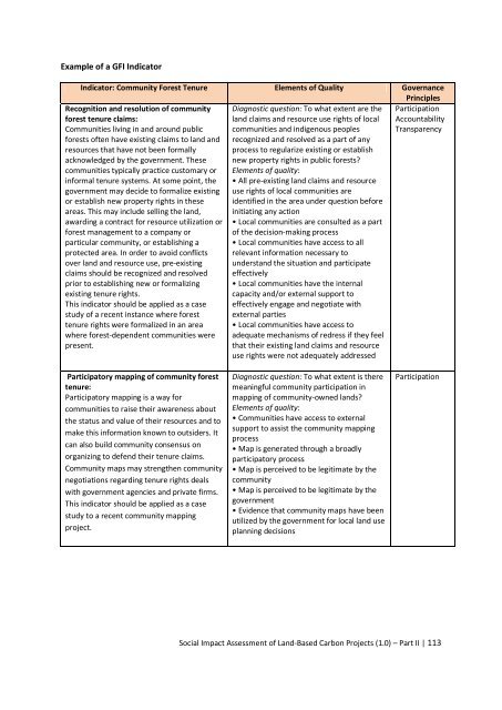
Example <strong>of</strong> a GFI Indicator<br />
Indicator: Community <strong>Forest</strong> Tenure Elements <strong>of</strong> Quality Governance<br />
Principles<br />
Recognition and resolution <strong>of</strong> community Diagnostic question: To what extent are the Participation<br />
<strong>for</strong>est tenure claims:<br />
<strong>land</strong> claims and resource use rights <strong>of</strong> local Accountability<br />
Communities living in and around public communities and indigenous peoples Transparency<br />
<strong>for</strong>ests <strong>of</strong>ten have existing claims to <strong>land</strong> and recognized and resolved as a part <strong>of</strong> any<br />
resources that have not been <strong>for</strong>mally process to regularize existing or establish<br />
acknowledged by the government. These new property rights in public <strong>for</strong>ests?<br />
communities typically practice customary or Elements <strong>of</strong> quality:<br />
in<strong>for</strong>mal tenure systems. At some point, the • All pre-existing <strong>land</strong> claims and resource<br />
government may decide to <strong>for</strong>malize existing use rights <strong>of</strong> local communities are<br />
or establish new property rights in these identified in the area under question be<strong>for</strong>e<br />
areas. This may include selling the <strong>land</strong>, initiating any action<br />
awarding a contract <strong>for</strong> resource utilization or • Local communities are consulted as a part<br />
<strong>for</strong>est management to a company or<br />
<strong>of</strong> the decision-making process<br />
particular community, or establishing a • Local communities have access to all<br />
protected area. In order to avoid conflicts relevant in<strong>for</strong>mation necessary to<br />
over <strong>land</strong> and resource use, pre-existing understand the situation and participate<br />
claims should be recognized and resolved effectively<br />
prior to establishing new or <strong>for</strong>malizing • Local communities have the internal<br />
existing tenure rights.<br />
capacity and/or external support to<br />
This indicator should be applied as a case effectively engage and negotiate with<br />
study <strong>of</strong> a recent instance where <strong>for</strong>est external parties<br />
tenure rights were <strong>for</strong>malized in an area • Local communities have access to<br />
where <strong>for</strong>est-dependent communities were adequate mechanisms <strong>of</strong> redress if they feel<br />
present.<br />
that their existing <strong>land</strong> claims and resource<br />
use rights were not adequately addressed<br />
Participatory mapping <strong>of</strong> community <strong>for</strong>est<br />
tenure:<br />
Participatory mapping is a way <strong>for</strong><br />
communities to raise their awareness about<br />
the status and value <strong>of</strong> their resources and to<br />
make this in<strong>for</strong>mation known to outsiders. It<br />
can also build community consensus on<br />
organizing to defend their tenure claims.<br />
Community maps may strengthen community<br />
negotiations regarding tenure rights deals<br />
with government agencies and private firms.<br />
This indicator should be applied as a case<br />
study to a recent community mapping<br />
project.<br />
Diagnostic question: To what extent is there<br />
meaningful community participation in<br />
mapping <strong>of</strong> community-owned <strong>land</strong>s?<br />
Elements <strong>of</strong> quality:<br />
• Communities have access to external<br />
support to assist the community mapping<br />
process<br />
• Map is generated through a broadly<br />
participatory process<br />
• Map is perceived to be legitimate by the<br />
community<br />
• Map is perceived to be legitimate by the<br />
government<br />
• Evidence that community maps have been<br />
utilized by the government <strong>for</strong> local <strong>land</strong> use<br />
planning decisions<br />
Participation<br />
Social Impact Assessment <strong>of</strong> Land-Based Carbon Projects (1.0) – Part II | 113