Jozani biodiversity inventory report 2002 - Coastal Forests of Kenya ...
Jozani biodiversity inventory report 2002 - Coastal Forests of Kenya ...
Jozani biodiversity inventory report 2002 - Coastal Forests of Kenya ...
You also want an ePaper? Increase the reach of your titles
YUMPU automatically turns print PDFs into web optimized ePapers that Google loves.
3.0 METHODS<br />
3.1 Vegetation sampling<br />
Botanical assessment <strong>of</strong> <strong>Jozani</strong>-Chwaka Bay proposed National Park ecosystem was carried out<br />
in order to produce information relevant to the environment impacts. The study involved<br />
identification <strong>of</strong> vegetation types and the species diversity comprising the flora <strong>of</strong> the area. This<br />
procedure enables to expose the threatened and rare species <strong>of</strong> the area, and suggestions <strong>of</strong> any<br />
conservation measures for the rare and endangered species. The floristic survey at the study area<br />
adopted three approaches:<br />
• Reconnaissance<br />
• Sampling intensity comprising <strong>of</strong> vegetation data collection and structured questionnaires.<br />
• Literature survey relevant to <strong>Jozani</strong>-Chwaka Bay proposed National Park.<br />
3.1.1 Reconnaissance<br />
This was carried out for 2 days (see also section 3.3.1) in order to identify different vegetation<br />
types and sites at which to establish sampling transects. Vegetation classification was based on<br />
the concepts <strong>of</strong> Greenway (1973) as modified by White (1983), Herlocker (1999) and Beentje<br />
(1994). This classification combines physiognomic and floristic criteria including the dominant<br />
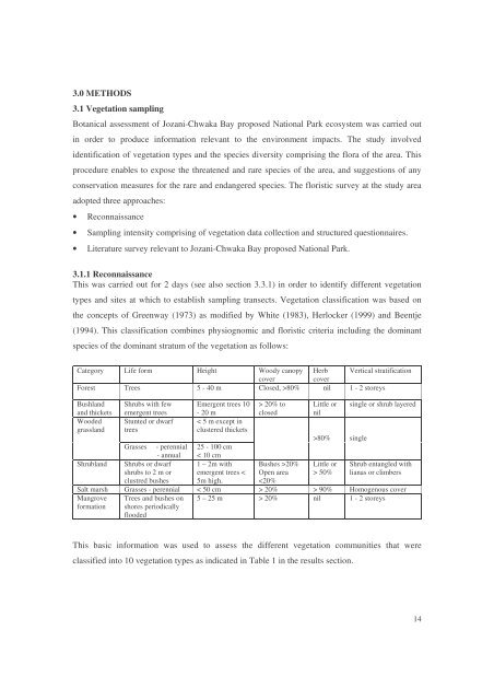
species <strong>of</strong> the dominant stratum <strong>of</strong> the vegetation as follows:<br />
Category Life form Height Woody canopy Herb Vertical stratification<br />
cover<br />
cover<br />
Forest Trees 5 - 40 m Closed, >80% nil 1 - 2 storeys<br />
Bushland Shrubs with few Emergent trees 10 > 20% to Little or single or shrub layered<br />
and thickets emergent trees - 20 m<br />
closed nil<br />
Wooded<br />
grassland<br />
Stunted or dwarf<br />
trees<br />
< 5 m except in<br />
clustered thickets<br />
>80% single<br />
Grasses - perennial<br />
- annual<br />
25 - 100 cm<br />
< 10 cm<br />
Shrubland Shrubs or dwarf<br />
shrubs to 2 m or<br />
1 – 2m with<br />
emergent trees <<br />
Bushes >20%<br />
Open area<br />
Little or<br />
> 50%<br />
Shrub entangled with<br />
lianas or climbers<br />
clustred bushes 5m high. 20% > 90% Homogenous cover<br />
Mangrove<br />
formation<br />
Trees and bushes on<br />
shores periodically<br />
flooded<br />
5 – 25 m > 20% nil 1 - 2 storeys<br />
This basic information was used to assess the different vegetation communities that were<br />
classified into 10 vegetation types as indicated in Table 1 in the results section.<br />
14


