

Jozani biodiversity inventory report 2002 - Coastal Forests of Kenya ...
Jozani biodiversity inventory report 2002 - Coastal Forests of Kenya ...
Jozani biodiversity inventory report 2002 - Coastal Forests of Kenya ...

Create successful ePaper yourself
Turn your PDF publications into a flip-book with our unique Google optimized e-Paper software.
large study area and time constraints transects were spaced to cater for both habitat and spatial<br />
distribution. Also due to a large gap in the knowledge <strong>of</strong> small mammals, amphibians and<br />
invertebrates in the study area the survey team concentrated much <strong>of</strong> its effort on the currently<br />
least known taxa and species. For the large and medium sized mammals which have been studied<br />
before and/or there is a substantial amount <strong>of</strong> information, the existing literature was used to<br />
provide information. Species diversity was calculated using the Shannon Weaver Index H' :<br />
nlog<br />
n − fi log fi<br />
i=<br />
1<br />
H'<br />
=<br />
n<br />
Where k = number <strong>of</strong> categories, f i = number <strong>of</strong> observations in category i, n = sample size.<br />
The maximum diversity which could be attained in the area was calculated using the expression:<br />
H' max = logk<br />
k<br />
<br />
Where H' max is the maximum possible diversity for a set <strong>of</strong> data consisting <strong>of</strong> k categories. H' tests<br />
abundance equality among k categories and is affected by the distribution <strong>of</strong> data and the number<br />
<strong>of</strong> categories. H' max is the highest diversity which can be calculated from a set <strong>of</strong> data consisting<br />
<strong>of</strong> k categories (Zar, 1996).<br />
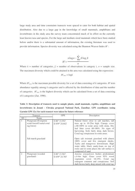
Table 3: Description <strong>of</strong> transects used to sample plants, small mammals, reptiles, amphibians and<br />
invertebrates in <strong>Jozani</strong> - Chwaka proposed National Park, Zanzibar. GPS coordinates (using<br />
Garmin GPS 12x) for each transect were taken for future reference<br />
Transect<br />
SN<br />
Name<br />
1 Wangwani (Evergreen<br />
scrub forest/<strong>Coastal</strong> coral<br />
rag forest)<br />
GPS<br />
S 06° 13.552'<br />
E 039° 24.642'<br />
Description<br />
Natural forest close to salt marshes, tall<br />
trees up to 10-25m high. Canopy cover<br />
c.60-100% in some areas with strata. Dry<br />
leaf litter cover 60-100%. No signs <strong>of</strong><br />
harvesting. Soils fairly deep, dark brown.<br />
Coral rag conspicuous in some areas.<br />
Salt marsh grassland<br />
2 Wangwani (wooded<br />
grassland)<br />
S 06° 13.563'<br />
E 039° 24.765'<br />
Open salt resistant grassland with almost<br />
100% cover and few emergent shrubs.<br />
Typha and mangroves downstream. High<br />
water table, black sandy-loam on top <strong>of</strong><br />
rocks and in some places the sub surface is<br />
composed <strong>of</strong> sand<br />
Annona senegalensis bushes predominant<br />
c.4-4m high. Grass cover 85% wood<br />
vegetation cover 10-15%. Coral rag<br />
emergent common and conspicuous. Soil<br />
dark brown fairly deep mixed with coral rag<br />
19


