

Jozani biodiversity inventory report 2002 - Coastal Forests of Kenya ...
Jozani biodiversity inventory report 2002 - Coastal Forests of Kenya ...
Jozani biodiversity inventory report 2002 - Coastal Forests of Kenya ...

You also want an ePaper? Increase the reach of your titles
YUMPU automatically turns print PDFs into web optimized ePapers that Google loves.
3.1.2 Vegetation data collection<br />
The classification and mapping <strong>of</strong> vegetation communities are the initial phases <strong>of</strong> ecological<br />
<strong>inventory</strong>. Sources <strong>of</strong> information include observations on, and measurements <strong>of</strong> species<br />
abundance, heights and diameter at breast height (DBH) for trees, how these attributes are<br />
influenced by the natural environment and by different types and intensities <strong>of</strong> land use practices.<br />
Eleven vegetation communities were recognized in this study area. Mangrove vegetation<br />
community was studied separately in another study.<br />
During sampling at least one transect line was established for each vegetation community that<br />
was identified during reconnaissance except for grassland, mangrove vegetation, shrubland and<br />
marine vegetation. Shrubland and grassland were not studied quantitatively but their species<br />
compositions were enumerated on various randomly selected sites. The mangrove vegetation and<br />
marine vegetation (algae and seagrasses) were not quantitatively assesed because they have<br />
already been separately studied in other studies (Shunula, 1997; Mohammed, 1999). The data<br />
were collected using a Nested Quadrat Method (Stohlgren et al, 1995; Crawley, 1997). Along<br />
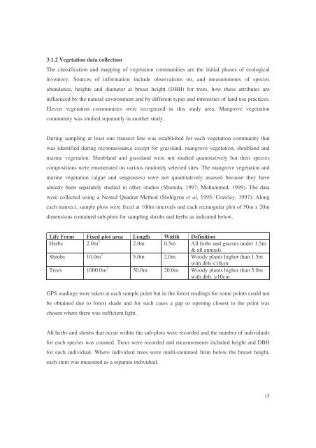
each transect, sample plots were fixed at 100m intervals and each rectangular plot <strong>of</strong> 50m x 20m<br />
dimensions contained sub-plots for sampling shrubs and herbs as indicated below.<br />
Life Form Fixed plot area Length Width Definition<br />
Herbs 2.0m 2 2.0m 0.5m All forbs and grasses under 1.5m<br />
& all annuals<br />
Shrubs 10.0m 2 5.0m 2.0m Woody plants higher than 1.5m<br />
with dbh 10cm<br />
GPS readings were taken at each sample point but in the forest readings for some points could not<br />
be obtained due to forest shade and for such cases a gap or opening closest to the point was<br />
chosen where there was sufficient light.<br />
All herbs and shrubs that occur within the sub-plots were recorded and the number <strong>of</strong> individuals<br />
for each species was counted. Trees were recorded and measurements included height and DBH<br />
for each individual. Where individual trees were multi-stemmed from below the breast height,<br />
each stem was measured as a separate individual.<br />
15


