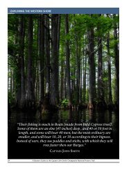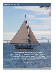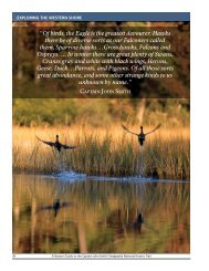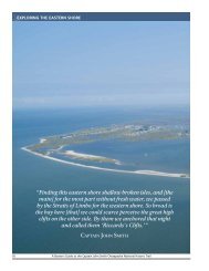
Draft Interpretive Plan Join the adventure! - Captain John Smith ...
Draft Interpretive Plan Join the adventure! - Captain John Smith ...
Draft Interpretive Plan Join the adventure! - Captain John Smith ...

Create successful ePaper yourself
Turn your PDF publications into a flip-book with our unique Google optimized e-Paper software.
APPENDIX D:<br />
TRAIL-RELATED RESOURCES<br />
APPENDIX C:<br />
Note: Appendix D is reprinted from <strong>the</strong> <strong>Captain</strong> <strong>John</strong> <strong>Smith</strong> Chesapeake National Historic Trail<br />
Feasibility Study and Environmental Assessment (July 2006). The trail-related resources appear<br />
in <strong>the</strong> study as Appendix C. The author is Project Historian <strong>John</strong> S. Salmon.<br />
TRAIL-RELATED SOURCES<br />
In <strong>the</strong> table on <strong>the</strong> following pages, <strong>the</strong><br />
blue-shaded rows list <strong>John</strong> <strong>Smith</strong>’s 1608<br />
voyage stops as <strong>the</strong>y are described in <strong>the</strong> draft<br />
book “<strong>John</strong> <strong>Smith</strong>’s Chesapeake Voyages<br />
1607-1609”, by Helen C. Rountree,<br />
Wayne E. Clark, and Kent Mountford (draft<br />
February 1, 2005). The 1608 date is shown in<br />
<strong>the</strong> leftmost column and <strong>the</strong> place name in <strong>the</strong><br />
second column.<br />
• Note that according to <strong>the</strong> book, <strong>the</strong><br />
meaning of <strong>the</strong> term “stop” varies<br />
considerably. At some stops, <strong>the</strong> boat<br />
landed and <strong>the</strong> crew disembarked to walk<br />
and explore <strong>the</strong> land, or to meet with native<br />
people living <strong>the</strong>re, or to camp for <strong>the</strong><br />
night. Some stops were merely an<br />
anchoring in a sheltered bay for one or<br />
more nights, without touching land. Some<br />
stops were not stops in <strong>the</strong> usual sense but<br />
merely a water-based exploration of a<br />
particular bay or creek before moving on.<br />
• Note also that <strong>the</strong> naming of stops varies;<br />
some are modern-day place names; some<br />
are names of <strong>Smith</strong>’s time, ei<strong>the</strong>r names he<br />
assigned or tribal names. When known,<br />
1608 names are italicized, unless <strong>the</strong> name<br />
has remained <strong>the</strong> same to <strong>the</strong> present time.<br />
• Note also that information on <strong>Smith</strong>’s<br />
Potomac River exploration is much<br />
sketchier and no dates are known.<br />
Therefore <strong>the</strong> “stops” are labeled according<br />
to geography ra<strong>the</strong>r than <strong>the</strong> date, and <strong>the</strong><br />
“Map ID Number” is merely a number<br />
preceded by <strong>the</strong> letter “P” for Potomac.<br />
Under each stop name, <strong>the</strong> white rows<br />
(indented) list any nearby federal, state or local<br />
public lands (as well as a few privately owned<br />
sites that may be open to public use). This<br />
includes National Parks, National Wildlife<br />
Refuges, National Wildlife Management Areas,<br />
state and local parks, municipal boat ramps,<br />
etc. These are considered potential resources<br />
to support <strong>the</strong> proposed trail.<br />
The columns to <strong>the</strong> right of each of <strong>the</strong>se<br />
indicate whe<strong>the</strong>r <strong>the</strong> resource provides<br />
restrooms, parking, public access to <strong>the</strong> water,<br />
and whe<strong>the</strong>r <strong>the</strong> site offers potential to provide<br />
information about and interpretation of <strong>the</strong><br />
proposed <strong>John</strong> <strong>Smith</strong> trail.<br />
The federal and state lands are shown on <strong>the</strong><br />
inset maps, Maps 3 through 7. The boat<br />
ramps are shown on Map 11.<br />
The final four pages of <strong>the</strong> table provide a list<br />
of Chesapeake Bay Gateway sites in proximity<br />
to <strong>the</strong> proposed trail routes, Voyage 1 and<br />
Voyage 2, with information about facilities and<br />
interpretation potential. These sites are listed<br />
not shown relative to voyage stops, but this<br />
may be seen on Maps 3 through 7.