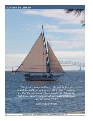
Draft Interpretive Plan Join the adventure! - Captain John Smith ...
Draft Interpretive Plan Join the adventure! - Captain John Smith ...
Draft Interpretive Plan Join the adventure! - Captain John Smith ...

Create successful ePaper yourself
Turn your PDF publications into a flip-book with our unique Google optimized e-Paper software.
Map Folders or Brochure<br />
Produce a simple foldout map and guide to help first-time users of <strong>the</strong> trail find <strong>the</strong>ir way.<br />
Such a folder may be <strong>the</strong> only publication that is needed to guide users on short day-use<br />
trails and overnight trails of 50 miles or less. Revise and update <strong>the</strong>se handy tools when<br />
you print a new supply. Depending on your financial resources, distribute <strong>the</strong>m as free<br />
publications or sales items.<br />
Map and Guides<br />
Create a water trail map and guide about <strong>the</strong> trail after testing <strong>the</strong> waters with <strong>the</strong> simple<br />
foldout map. You may find that a larger publication is both needed and desired by users<br />
to convey practical visit information in greater depth and to provide boaters with detailed<br />
inset maps of certain areas (such as directions to access points, water hazard areas, and<br />
dam portages). To widen <strong>the</strong> appeal of <strong>the</strong> map and guide, it could contain interpretive<br />
essays and features about <strong>the</strong> area’s natural, historical, and recreational features.<br />
Depending on <strong>the</strong> number of pages, use of color, and o<strong>the</strong>r factors, map and guides can<br />
be costly to develop and print. Selling map and guides can be an important source of<br />
revenue for your water trail. This revenue can be used to fund a reprint of <strong>the</strong> map and<br />
guide and development of water trail facilities.<br />
Websites<br />
Develop a website so potential users can download and print out <strong>the</strong> water trail map and<br />
basic information to plan <strong>the</strong>ir trip. . Increasingly, websites are <strong>the</strong> first places people<br />
search to get travel and recreation information. Keep <strong>the</strong> website up to date and, as time<br />
permits, add links to local outfitters, area accommodations, points of interest, and related<br />
sites.<br />
Signs<br />
Produce orientation, interpretive and wayfinding signs to increase <strong>the</strong> public’s awareness<br />
of <strong>the</strong> trail, to direct visitors, to identify sites, and to indicate hazards. Hire a professional<br />
design firm to create a signage plan for <strong>the</strong> whole trail, so <strong>the</strong> signs will have a consistent<br />
appearance from one end to <strong>the</strong> o<strong>the</strong>r. The sign plan will also provide formats and<br />
instructions for adding and replacing signs in <strong>the</strong> future.<br />
Wayside Exhibits<br />
Install wayside exhibits at launch sites to provide orientation information, a map of <strong>the</strong><br />
trail, safety tips, and regulations. As funds permit, produce wayside exhibits that interpret<br />
natural and human history stories related to stopping-off sites along <strong>the</strong> trail. Hire<br />
professionals to design and fabricate <strong>the</strong> exhibits and bases, so <strong>the</strong>y convey a consistent,<br />
standard approach that will enhance <strong>the</strong> trail’s identity.<br />
Developing Wayfinding Guides<br />
Unlike a clear path through <strong>the</strong> woods, a water trail is a nebulous entity. But, oddly<br />
enough, identifying <strong>the</strong> watery route in a map folder and guidebook, on signs and<br />
exhibits, and on <strong>the</strong> World Wide Web bring a sense of reality to <strong>the</strong> trail. These<br />
191