Draft Interpretive Plan Join the adventure! - Captain John Smith ...
Draft Interpretive Plan Join the adventure! - Captain John Smith ...
Draft Interpretive Plan Join the adventure! - Captain John Smith ...

Create successful ePaper yourself
Turn your PDF publications into a flip-book with our unique Google optimized e-Paper software.
Project Title Year<br />
Initiated<br />
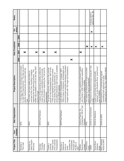
Develop a<br />
Trail Logo<br />
Develop an<br />
Initial Unigrid<br />
Brochure<br />
Develop<br />
Traveling<br />
Exhibits<br />
Create a<br />
Colonial<br />
Poster Guide<br />
(The Colonial<br />
Chesapeake)<br />
Develop a<br />
Reference<br />
book re;<br />
<strong>Smith</strong><br />
Voyages, <strong>the</strong><br />
Chesapeake<br />
Peoples and<br />
<strong>the</strong> Bay of<br />
1607<br />
Shallop<br />
Reenactment<br />
Voyage<br />
<strong>Interpretive</strong><br />
Tours<br />
Site/ Organization Project Description Date Completed Ongoing<br />
2006 2007 2008 2009<br />
NPS A Trail logo has been developed (and revised<br />
to meet NPS requirements). The logo serves to<br />
identify media/products associated with <strong>the</strong><br />
X<br />
Trail.<br />
NPS The tri-fold, full-color leaflet provides an<br />
overview of <strong>the</strong> Trail, including a notation<br />
regarding <strong>the</strong> trail planning process. The<br />
leaflet was available in time for <strong>the</strong> May 2007<br />
X<br />
launch of Trail.<br />
NPS/Trail Partners A series of free-standing exhibits outline <strong>the</strong><br />
routes of <strong>Smith</strong>’s explorations and provide<br />
basic information regarding <strong>the</strong> Trail and its<br />
X<br />
development.<br />
NPS The guide introduces visitors to <strong>the</strong> colonial<br />
period on <strong>the</strong> Chesapeake from 1607 to <strong>the</strong><br />
1700s and highlights <strong>the</strong> Gateways where<br />
those stories may be experienced; an<br />
associated interactive web module is available<br />
X<br />
on <strong>the</strong> CBGN website.<br />
NPS/Trail Partners (<strong>John</strong> <strong>Smith</strong>’s Chesapeake Voyages 1607-<br />
1609) A team of historians, archeologists and<br />
environmental scientists developed a fourteenchapter<br />
book with 150 maps and illustrations.<br />
Sultana Projects, Inc.,<br />
Chestertown, MD & Trail<br />
Partners<br />
A crew of modern explorers retraced <strong>Captain</strong><br />
<strong>John</strong> <strong>Smith</strong>’s 1608 Chesapeake expedition<br />
traveling in a replica shallop.<br />
NPS Two seasonal interpretive rangers provided<br />
tours of <strong>the</strong> Trail at Jamestown.<br />
X<br />
CBIBS NOAA & Trail Partners Placement of interactive buoys along <strong>the</strong> Trail<br />
Smart Buoy<br />
Gateway<br />
Kiosk<br />
MOU between<br />
NOAA & NPS<br />
X<br />
X<br />
Notes<br />
route.<br />
x x<br />
6 buoys were in<br />
NOAA & Nauticus Install a land kiosk that is electronically<br />
“te<strong>the</strong>red” to <strong>the</strong> Elizabeth River “smart buoy”<br />
(part of CBIBS).<br />
NOAA & NPS Memorandum of Understanding signed<br />
committing both agencies to work<br />
collaboratively on <strong>the</strong> Trial, CBIBS & CBGN.<br />
x<br />
x<br />
place by Dec. 08