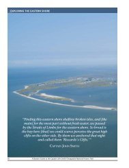
Draft Interpretive Plan Join the adventure! - Captain John Smith ...
Draft Interpretive Plan Join the adventure! - Captain John Smith ...
Draft Interpretive Plan Join the adventure! - Captain John Smith ...

You also want an ePaper? Increase the reach of your titles
YUMPU automatically turns print PDFs into web optimized ePapers that Google loves.
1. Identify <strong>the</strong> location of <strong>the</strong> original Jamestown Fort.<br />
2. Identify artifacts from archeological exploration of <strong>the</strong> Jamestown Fort location.<br />
3. Construct a short fictional account about life among Jamestown's first inhabitants.<br />
http://www2.vcdh.virginia.edu/teaching/jamestown/fort.html<br />
<strong>Smith</strong>’s Journals<br />
• <strong>John</strong> <strong>Smith</strong>’s 1st Voyage Exploring <strong>the</strong> Chesapeake Bay - A Worksheet for<br />
Grades 4-5<br />
Students will be able to:<br />
1) Interpret a primary source; <strong>John</strong> <strong>Smith</strong>’s map and excerpts from his journal.<br />
2) Identify places on a map that show <strong>John</strong> <strong>Smith</strong>’s route.<br />
3) Identify geographic characteristics seen by <strong>John</strong> <strong>Smith</strong> on his first voyage of <strong>the</strong><br />
Chesapeake Bay.<br />
http://www.johnsmith400.org/<strong>John</strong>_<strong>Smith</strong>_1st_Voyage_2.pdf<br />
<strong>Smith</strong>’s Maps<br />
• A PDF 4-page print out of <strong>Smith</strong>’s 1612 map.<br />
http://www.johnsmith400.org/JOHN_SMITH_MAP.pdf<br />
• Using <strong>John</strong> <strong>Smith</strong>'s Map of <strong>the</strong> Chesapeake Bay - A Worksheet for Grades 4-5<br />
Students will be able to:<br />
1) Interpret a primary source; <strong>John</strong> <strong>Smith</strong>’s map and excerpts from his journal.<br />
2) Identify places on a map that show <strong>John</strong> <strong>Smith</strong>’s routes.<br />
3) Identify map elements on <strong>Smith</strong>’s map.<br />
http://www.johnsmith400.org/UsingMapinClassroom.pdf<br />
• <strong>John</strong> <strong>Smith</strong>, A Map of Virginia, 1612 - The Library at The Mariners'<br />
Museum<br />
This program is an interactive version of <strong>John</strong> <strong>Smith</strong>’s 1612 map. In this application<br />
users can see <strong>the</strong> relationship between <strong>the</strong> map and passages from <strong>the</strong> book.<br />
http://www.mariner.org/chesapeakebay/colonial/col009.html<br />
The Shallop<br />
• <strong>Captain</strong> <strong>John</strong> <strong>Smith</strong>'s Shallop<br />
Organization: <strong>John</strong> <strong>Smith</strong> 400<br />
Grade(s): 4 - 5<br />
Students will be able to:<br />
126