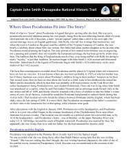
Draft Interpretive Plan Join the adventure! - Captain John Smith ...
Draft Interpretive Plan Join the adventure! - Captain John Smith ...
Draft Interpretive Plan Join the adventure! - Captain John Smith ...

Create successful ePaper yourself
Turn your PDF publications into a flip-book with our unique Google optimized e-Paper software.
what <strong>the</strong>y knew about <strong>the</strong>ir homeland. They drew maps in <strong>the</strong> earth, described <strong>the</strong> distant<br />
terrain up <strong>the</strong> rivers, and told <strong>Smith</strong> about o<strong>the</strong>r tribes.<br />
From <strong>the</strong> information <strong>Smith</strong> ga<strong>the</strong>red, he compiled a map of <strong>the</strong> Bay and wrote<br />
extensively about what he had learned. Just before <strong>the</strong> voyages, <strong>Smith</strong> had sent to<br />
England a sketch map of that part of <strong>the</strong> Bay and its river system that he had seen thus<br />
far, as well as a letter to a friend. The letter and map were published later in 1608 as A<br />
True Relation of such occurrences and accidents of noate as hath hapned in Virginia<br />
since <strong>the</strong> first planting of that Collony. After <strong>the</strong> voyages, and after he returned to<br />
England in 1609, <strong>Smith</strong> set about turning A True Relation and his notes and sketch maps<br />
into a book. The result, A Map of Virginia, appeared in 1612. It consists of a book in<br />
two parts, and <strong>the</strong> map, which was reissued in many “states” between <strong>the</strong>n and 1632.<br />
The first part of <strong>the</strong> book is <strong>Smith</strong>’s “Description of <strong>the</strong> Country,” which details <strong>the</strong> fauna<br />
and flora of <strong>the</strong> Chesapeake region, as well as <strong>the</strong> American Indians who lived <strong>the</strong>re. The<br />
second part describes <strong>the</strong> history of <strong>the</strong> colony and has a separate title page: The<br />
Proceedings of <strong>the</strong> English Colonie In Virginia since <strong>the</strong>ir first beginning from England<br />
in <strong>the</strong> yeare of our Lord 1606, till this present 1612. Although <strong>Smith</strong> contributed to this<br />
section, o<strong>the</strong>r authors’ names are on <strong>the</strong> title page. Interestingly, three of <strong>the</strong>m—Anas<br />
Todkill, Walter Russell, and Nathaniel Powell—accompanied <strong>Smith</strong> on one or both of his<br />
Chesapeake Bay voyages. In 1624, <strong>Smith</strong> published his magnum opus, The Generall<br />
Historie of Virginia, New-England, and <strong>the</strong> Summer Isles.<br />
During his time in Virginia, and especially during <strong>the</strong> voyages on <strong>the</strong> Chesapeake Bay,<br />
<strong>John</strong> <strong>Smith</strong> saw more with his own eyes or through <strong>the</strong> eyes of <strong>the</strong> Indians than any o<strong>the</strong>r<br />
Englishman <strong>the</strong>n in Virginia. He ga<strong>the</strong>red data for a map that would guide English<br />
explorers and settlers for decades to come. He journeyed a great distance for <strong>the</strong> time, in<br />
an open boat with crews that were often ill; he faced storms and combat; and he brought<br />
his men and his vessel safely home. He formed alliances with several American Indian<br />
tribes. Regardless of <strong>the</strong> repercussions, <strong>Smith</strong> and his companions had survived a grand<br />
<strong>adventure</strong>, and <strong>the</strong> voyages were a great accomplishment.<br />
The expeditions had far-reaching consequences. <strong>Smith</strong>’s “discoveries,” recorded in his<br />
maps and books, helped to change <strong>the</strong> Virginia Company policy toward private<br />
landholding, and promoted <strong>the</strong> eventual transformation of <strong>the</strong> Bay’s environment through<br />
<strong>the</strong> settlers’ farming and exploitation of natural resources. The subsequent large-scale<br />
immigration from England increased <strong>the</strong> pressure on <strong>the</strong> native peoples and <strong>the</strong> Bay<br />
itself. <strong>Smith</strong>’s model for settlement in <strong>the</strong> Bay region largely became <strong>the</strong> model for<br />
English America from New England to <strong>the</strong> Carolinas. His maps served settlers and<br />
colonial governments until late in <strong>the</strong> seventeenth century. And <strong>the</strong> stories of his exploits<br />
continue to intrigue Americans today.<br />
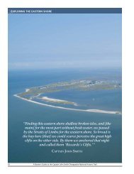
Chesapeake Bay Native Americans<br />
The distribution of American Indian polities around <strong>the</strong> Chesapeake Bay, <strong>the</strong>ir internal<br />
structures and hierarchies, <strong>the</strong>ir relationships with one ano<strong>the</strong>r, and <strong>the</strong> relative levels of<br />
power or authority among <strong>the</strong>ir leaders, have been subjects of much scholarly research,<br />
111