FINAL VERSION FOR APPROVAL - Sdn Bhd - WWF Malaysia
FINAL VERSION FOR APPROVAL - Sdn Bhd - WWF Malaysia
FINAL VERSION FOR APPROVAL - Sdn Bhd - WWF Malaysia

Create successful ePaper yourself
Turn your PDF publications into a flip-book with our unique Google optimized e-Paper software.
Gunung Stong State Park Preliminary Management Plan<br />
The mountains on the east (the Eastern Range), west (Main Range or Titiwangsa Range), and<br />
south (Tahan Range), forming a U-shaped trough, channels drainage northwards into the<br />
South China Sea. Pareto’s Law prevails in Kelantan: some 20% of her landmass (the Sg.<br />
Kelantan delta) is peopled by 80% of her population, while 80% of her landmass (the forested<br />
highlands in the south, east, and west) is only settled by 20% of the population.<br />
This has prevailed until today, though the completion of the Kuala Lumpur-Gua Musang<br />
road opened up vast swathes of land in the interior for (mostly) plantation agriculture<br />
managed by KESEDAR (South Kelantan Land Development Authority), FELDA, and<br />
FELCRA, and encouraging pioneers to settle in the interior. Apart from pioneers encouraged<br />
by the various organised settlement schemes, there are the illegal pioneers that encroached<br />
into forest reserves in the hope of them being de-gazetted and alienated into agriculture.<br />
The clearing of forestland for agriculture is giving rise to the following impacts:<br />
• Habitat for wildlife and natural plants shrink considerably, and as their food sources<br />
are depleted, wildlife raids agricultural crop and attack livestock. This has happened<br />
with increasing frequency in Jeli and Gua Musang, with reports of human-wildlife<br />
conflicts including elephant and tiger attacks. This is more pertinent when it is<br />
realised that salt-licks, sources of mineral and salts for wildlife, have been disturbed<br />
for highway construction, and development for oilpalm plantations in South<br />
Kelantan.<br />
• Greater networks of logging tracks and expansion of plantations means improved<br />
access to remaining forested areas for hunters and forest product collectors, and the<br />
threat to conservation has increased significantly. There is a thriving underground<br />
market for animal products and parts, especially for use in traditional preparations for<br />
virility and health. Additionally, our forests have also been infiltrated by foreigners<br />
seeking gaharu or sandalwood (and poaching as a sideline). This is indicated by<br />
frequent cases of wildlife traffickers and sandalwood collectors caught by the<br />
authorities, and as reported in the newspapers.<br />
• Kelantan has a long tradition of pioneers opening up forestland for agriculture and<br />
farming, and this is supported by the state in issuing legal title after some period of<br />
time. The clearing of forestlands for agriculture has a multiplier effect: pioneers open<br />
up new land, fragmenting once extensive forests into “islands” surrounded by a sea of<br />
plantation and small-scale agriculture, and the process is self-repeating, with the more<br />
accessible forest reserves nibbled by these pioneers, following logging trails.<br />
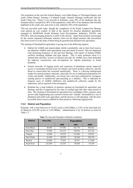
1.5.2 District and Population<br />
Kelantan, with a total land area of 14,922 sq km (1,492,200ha), is 4.4% of the total land size<br />
of <strong>Malaysia</strong> (336,700 sq km or 3,367,000ha). Administration is by 10 districts as listed in<br />
Table 1.3.<br />
District<br />
Table 1.3: Area and Population of Districts in Kelantan<br />
Area (Ha)<br />
Population<br />
1980 1991 2000<br />
Kota Bharu 40,900 275,986 366,770 406,662<br />
Pasir Mas 57,800 118,153 150,036 165,126<br />
Tumpat 16,800 85,952 116,044 134,812<br />
Pasir Puteh 43,300 80,959 96,348 106,138<br />
Bachok 26,400 73,953 98,557 111,040<br />
Kuala Krai 222,500 62,301 90,830 93,550<br />
7