FINAL VERSION FOR APPROVAL - Sdn Bhd - WWF Malaysia
FINAL VERSION FOR APPROVAL - Sdn Bhd - WWF Malaysia
FINAL VERSION FOR APPROVAL - Sdn Bhd - WWF Malaysia
Create successful ePaper yourself
Turn your PDF publications into a flip-book with our unique Google optimized e-Paper software.
Gunung Stong State Park Preliminary Management Plan<br />
return trip is through the saddle between, G. Stong and G. Ayam, to G. Stong, and straight<br />
down to Baha Camp.<br />
In general, there are still visible signs that GSSP have been extensively logged some time in<br />
the mid to late 1980s, as evidenced by the abandoned logging trails that extend up to the<br />
1000m limits. At lower elevations and on the more undulating ground, these logging trails<br />
have provided access for settlers to encroach into areas surrounding GSSP, establishing<br />
dwellings, smallholdings, and fruit farms, in the hope of obtaining legal title in the future.<br />
However, since most of GSSP is steeply sloped, encroachment seemed to be limited to three<br />
areas: the Jelawang approach to the waterfall, and to the Sg. Stong river plain that is off the<br />
Jelawang-Gua Musang federal road, and along the edges of the Jelawang-Gua Musang Road<br />
(see Appendix 4). Possibly, the steep, rocky slopes beyond these areas have deterred further<br />
encroachments.<br />
The logged-over patches and logging trails have encouraged the growth of pioneer and<br />
sunlight-loving species, with a profusion of bamboo thickets, gingers, ferns and wild bananas,<br />
and pioneer woody species (typically Macaranga spp., Melastoma spp., Alstonia spp.,<br />
Elateriospermum tapos) are dominant.<br />
There are numerous signs (droppings, prints, and calls) of the presence of wildlife, such as<br />
elephants, gibbons, tigers, deer and wild boar. There are also signs pointing to the presence of<br />
agarwood (Aquilaria spp.) collectors, with their campsites and markings on tree trunks, off<br />
the usual trails.<br />
The upper levels of GSSP are frequently shrouded in mists, due to the upwelling of humid air<br />
from the lowlands that develops into late afternoon thunderstorms and showers. Due to its<br />
granite base, the topsoil is shallow, and this leads to low water retention that easily leads to<br />
mini-cascades and waterfalls along seasonal streambeds, and over-flooding of the riverbanks<br />
within GSSP. This is especially felt at Baha Camp, the base of the waterfall, and the loop<br />
near the Sekolah kebangsaan Mempelam, Jelawang.<br />
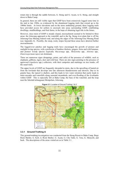
Figure 3.1: Location of Ground Truthing 1 & 2<br />
3.3.1 Ground-Truthing A<br />
This ground-truthing investigation was conducted from the Stong Resort to Baha Camp, Bogo<br />
Rock Shelter, G. Kob, Li Rock Shelter, G. Ayam, G. Che Tahir, G. Tera, G. Menyelit, and<br />
back. The descriptions of the areas visited are as in Table 3.1.<br />
32


