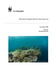
Gunung Stong State Park Preliminary Management Plan 1.5.6 Geology Generally, the highlands west, south, and east in Kelantan are granitic in origin, characterised as the Main Range granite, Stong Igneous Complex, Ulu Lalat (Senting) granite, Boundary Range granite, and Kemahang granite. The northern plain or the Sg. Kelantan delta, is covered by alluvial sediment, while the coast is sediment overlaid by sand derived from marine sources. Central and south Kelantan is composed of Triassic rocks interspersed with Permian rocks. The Triassic rocks consist of interbedded sandstone and siltstone, shale, with some volcanic intercalations, while the Permian rocks are of phyllite, slate, shale and limestone (Rishworth, 1974, in Chu et al., 1982). In the extreme south-east, overlying the Boundary Range granite, are Cretaceous-Jurassic rocks mainly of continental deposits. These continental rocks are the youngest in the State, and overlay the Boundary Range granite, and Triassic sediments in the tri-state border region of Kelantan, Terengganu, and Pahang, within Taman Negara. The oldest rocks in the State are in the foothills of the Main Range (with a northwards trending belt), which are Lower Palaeozoic in age, consisting of metapelites, with lesser amounts of volcanic fragmentals, and arenaceous intercalations (MacDonald, 1967, in Chu et al., 1982). 1.5.7 Minerals Gold in Kelantan are of two types, alluvial gold, and lode gold, with the former being more widespread, particularly in the Sg. Galas, Sg. Pergau, and Taku Schist region, at Sg. Sokor, Sg. Wias, and at Kg. Pulai, while lode gold is mostly in Gua Musang and Sokor. Gold in Pulai was mined as early as the 18 th century, from alluvial gold obtained from hydrothermal quartz veins (MacDonald, 1967, in Chu et al., 1982), but production has stopped due to subeconomic quantities of gold. Through an agreement with the Sultan, Duff Development had played an important role in mineral prospecting in Kelantan since 1903. In terms of gold production, Tanah Merah is the most productive district, with 88,288 g of gold produced in 2001, followed by Jeli (12,485 g), Kuala Krai (8,353 g), and Gua Musang (2,770 g), with much of the gold from the Sokor-Taku region (Dept. of Minerals and Geoscience, Kelantan, 2001, in UPEN Kelantan, 2002). Iron is located at several locations in the State, but the most economically viable was at Temangan, made of secondary limonite, hematite, and goethite over primary siderite occurring along faulted contact between the Taku Schist and adjacent shales (MacDonald, 1967, and Bean, 1969, in Chu et al., 1982). However, the mine, operational in 1819, has since closed. Barite, as hydrothermal veins capped by hematite, occurs at Sg. Perdah and Bt. Pencuri, in the Gua Musang area. These two barite outcrops are located within arenaceous and argillaceous sediments of the Permian age. Production was at 716.25 tonnes in 1999, 1816.40 tonnes in 2000, and 649.10 tonnes in 2001 (Kelantan Dept. of Minerals and Geosciences, 2001, from UPEN Kelantan, 2002). 1.5.8 Forest Resources Some 60% (894,271 ha) of the land area of Kelantan is under forest, of which, 629,687 ha (70%) is under Permanent Reserved Forests (PRFs), 108,783 ha (12%) is under Taman Negara, and 155,801 ha (18%) is under state land (Jabatan Perhutanan Negeri Kelantan, undated). PRFs are managed by the Kelantan State Forestry Department, Taman Negara is by DWNP, while state land is under the respective land offices. In terms of conservation, only the forest under Taman Negara is fully protected. 12
Gunung Stong State Park Preliminary Management Plan Logging is conducted within PRFs and state land, and is a major revenue for the state, accounting for RM41.37 m in 1999 (47% of the state revenue). As at 2003, there are 35 PRFs managed by three district forestry offices based respectively at Kuala Krai (East Kelantan), Tanah Merah (West Kelantan) and Gua Musang (South Kelantan). The PRFs and their management office are listed in Table 1.8 below. Table 1.8: Permanent Reserved Forests in Kelantan No. Forest Reserve Area (ha) Date Gazetted West Kelantan 1 Balah 56,010 01.09.1990 2. Berangkat 21,409 09.09.1941 3. Bukit Akar 1,072 11.05.1989 4. G. Basor 40,613 11.05.1989 5. G. Stong Selatan 28,134 11.05.1989 6. G. Stong Tengah 21,950 11.05.1989 7. G. Stong Utara 11,044 11.05.1989 8. Jedok 4,382 01.01.1957 9. Jeli 3,649 06.06.1991 10. Jentiang 13,673 11.05.1989 11. Sg. Sator 2,777 01.04.1962 12. Sokotaku 21,825 10.10.1960 Sub-Total 226,538 South Kelantan 13. Batu Papan 17,580 11.05.1989 14. Bukit Hantu 3,134 11.05.1989 15. Chiku 759 11.05.1989 16. G. Rabong 16,355 11.05.1989 17. Limau Kasturi 2,107 11.05.1989 18. Lojing 13,063 11.05.1989 19. Nenggiri 21,160 11.05.1989 20. Perias 60,355 01.03.1990 21. Sg. Betis 55,953 11.05.1989 22. Sg. Brok 25,824 11.05.1989 23. Sg. Terah 4,442 11.05.1989 24. Ulu Galas 13,215 11.05.1989 Sub-Total 233,947 East Kelantan 25. Chabang Tongkat 4,863 07.11.1946 26. Lebir 47,549 01.01.1957 27. Relai 39,432 01.01.1957 13