FINAL VERSION FOR APPROVAL - Sdn Bhd - WWF Malaysia
FINAL VERSION FOR APPROVAL - Sdn Bhd - WWF Malaysia
FINAL VERSION FOR APPROVAL - Sdn Bhd - WWF Malaysia

You also want an ePaper? Increase the reach of your titles
YUMPU automatically turns print PDFs into web optimized ePapers that Google loves.
Gunung Stong State Park Preliminary Management Plan<br />
from production forests are based on annual production targets (coupes) decided at the<br />
Forestry Department headquarters, and there are cutting limits on diameter size at breastheight<br />
(dbh), while stateland and private land are not coupe-based, and nor are they limited by<br />
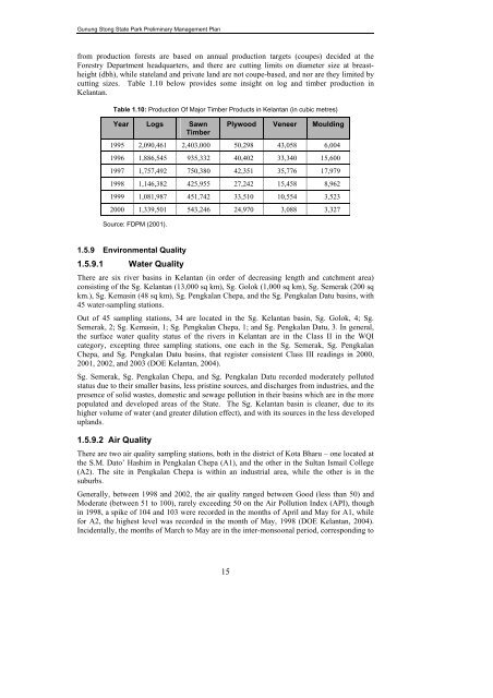
cutting sizes. Table 1.10 below provides some insight on log and timber production in<br />
Kelantan.<br />
Table 1.10: Production Of Major Timber Products in Kelantan (in cubic metres)<br />
Year Logs Sawn<br />
Timber<br />
Plywood Veneer Moulding<br />
1995 2,090,461 2,403,000 50,298 43,058 6,004<br />
1996 1,886,545 935,332 40,402 33,340 15,600<br />
1997 1,757,492 750,380 42,351 35,776 17,979<br />
1998 1,146,382 425,955 27,242 15,458 8,962<br />
1999 1,081,987 451,742 33,510 10,554 3,523<br />
2000 1,339,501 543,246 24,970 3,088 3,327<br />
Source: FDPM (2001).<br />
1.5.9 Environmental Quality<br />
1.5.9.1 Water Quality<br />
There are six river basins in Kelantan (in order of decreasing length and catchment area)<br />
consisting of the Sg. Kelantan (13,000 sq km), Sg. Golok (1,000 sq km), Sg. Semerak (200 sq<br />
km.), Sg. Kemasin (48 sq km), Sg. Pengkalan Chepa, and the Sg. Pengkalan Datu basins, with<br />
45 water-sampling stations.<br />
Out of 45 sampling stations, 34 are located in the Sg. Kelantan basin, Sg. Golok, 4; Sg.<br />
Semerak, 2; Sg. Kemasin, 1; Sg. Pengkalan Chepa, 1; and Sg. Pengkalan Datu, 3. In general,<br />
the surface water quality status of the rivers in Kelantan are in the Class II in the WQI<br />
category, excepting three sampling stations, one each in the Sg. Semerak, Sg. Pengkalan<br />
Chepa, and Sg. Pengkalan Datu basins, that register consistent Class III readings in 2000,<br />
2001, 2002, and 2003 (DOE Kelantan, 2004).<br />
Sg. Semerak, Sg. Pengkalan Chepa, and Sg. Pengkalan Datu recorded moderately polluted<br />
status due to their smaller basins, less pristine sources, and discharges from industries, and the<br />
presence of solid wastes, domestic and sewage pollution in their basins which are in the more<br />
populated and developed areas of the State. The Sg. Kelantan basin is cleaner, due to its<br />
higher volume of water (and greater dilution effect), and with its sources in the less developed<br />
uplands.<br />
1.5.9.2 Air Quality<br />
There are two air quality sampling stations, both in the district of Kota Bharu – one located at<br />
the S.M. Dato’ Hashim in Pengkalan Chepa (A1), and the other in the Sultan Ismail College<br />
(A2). The site in Pengkalan Chepa is within an industrial area, while the other is in the<br />
suburbs.<br />
Generally, between 1998 and 2002, the air quality ranged between Good (less than 50) and<br />
Moderate (between 51 to 100), rarely exceeding 50 on the Air Pollution Index (API), though<br />
in 1998, a spike of 104 and 103 were recorded in the months of April and May for A1, while<br />
for A2, the highest level was recorded in the month of May, 1998 (DOE Kelantan, 2004).<br />
Incidentally, the months of March to May are in the inter-monsoonal period, corresponding to<br />
15