Consultation Draft 1 - Stoke-on-Trent City Council
Consultation Draft 1 - Stoke-on-Trent City Council
Consultation Draft 1 - Stoke-on-Trent City Council

You also want an ePaper? Increase the reach of your titles
YUMPU automatically turns print PDFs into web optimized ePapers that Google loves.
CONNECTIVITY 5<br />
5.1 The Transport Hierarchy<br />
Currently, there is no adopted transport strategy to support the<br />
regenerati<strong>on</strong> of the <strong>City</strong> Centre. However, the Highways Authority<br />
have requested that the public realm supports a hierarchy of<br />
users within the <strong>City</strong> Centre, as follows:-<br />
1. pedestrians (to include mobility impaired)<br />
2. cyclists<br />
3. public transport (including taxis)<br />
4. goods servicing vehicles<br />
5. private vehicles<br />
It is intended that design interventi<strong>on</strong>s within the public realm<br />
supporting a range of transport modes will promote a choice of<br />
transport opti<strong>on</strong>s, reducing reliance <strong>on</strong> the private car.<br />
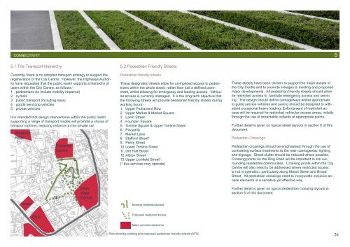
Waterloo<br />
Road<br />
Tesco<br />
6<br />
Potteries<br />
Centre<br />
12<br />
3<br />
8<br />
7<br />
4<br />
5<br />
2<br />
1<br />
9<br />
10 11<br />
East/<br />
West<br />
13 Centre<br />
5.2 Pedestrian Friendly Streets<br />
Pedestrian friendly streets<br />
These designated streets allow for unimpeded access to pedestrians<br />
within the whole street, rather than just a defined pavement,<br />
whilst allowing for emergency and loading access. Vehicular<br />
access is currently managed. It is the l<strong>on</strong>g term objective that<br />
the following streets will provide pedestrian friendly streets during<br />
working hours:-<br />
1. Upper Parliament Row<br />
2. Upper Market & Market Square<br />
3. Lamb Street<br />
4. Fountain Square<br />
5. T<strong>on</strong>tine Square & Upper T<strong>on</strong>tine Street<br />
6. Piccadilly<br />
7. Market Lane<br />
8. Stafford Street*<br />
9. Percy Street<br />
10. Lower T<strong>on</strong>tine Street<br />
11. Old Hall Street<br />
12. Albi<strong>on</strong> Street<br />
13. Upper Lichfield Street*<br />
(* bus services may operate)<br />
Existing restricted access<br />
These streets have been chosen to support the major assets of<br />
the <strong>City</strong> Centre and to promote linkages to existing and proposed<br />
major developments. All pedestrian friendly streets should allow<br />
for restricted access to facilitate emergency access and servicing.<br />
The design should define carriageways where appropriate<br />
to guide service vehicles and paving should be designed to withstand<br />
occasi<strong>on</strong>al heavy loading. Enforcement of restricted access<br />
will be required for restricted vehicular access areas, initially<br />
through the use of retractable bollards at appropriate points.<br />
Further detail is given <strong>on</strong> typical street layouts in secti<strong>on</strong> 6 of this<br />
document.<br />
Pedestrian Crossings<br />
Pedestrian crossings should be emphasised through the use of<br />
c<strong>on</strong>trasting surface treatments to the main carriageway, lighting<br />
and signage. Street clutter should be reduced where possible.<br />
Crossing points <strong>on</strong> the Ring Road will be important to link surrounding<br />
residential communities. Crossing points within the <strong>City</strong><br />
Centre will also need to be addressed where restricted access<br />
is not in operati<strong>on</strong>, particularly al<strong>on</strong>g Marsh Street and Broad<br />
Street. All pedestrian crossings need to incorporate inclusive access<br />
elements in a sensitive yet effective way.<br />
Further detail is given <strong>on</strong> typical pedestrian crossing layouts in<br />
secti<strong>on</strong> 6 of this document.<br />
CBD<br />
Proposed restricted access<br />
Major commercial anchor<br />
Plan showing existing and proposed pedestrian friendly streets (NTS)<br />
26