- Page 1 and 2:
FSUTMS-CUBE MODELING TRAINING SERIE
- Page 3 and 4:
PREFACE This four-day training cour
- Page 5 and 6:
ACKNOWLEDGMENTS This four-day train
- Page 7 and 8:
AGENDA FSUTMS COMPREHENSIVE MODELIN
- Page 9 and 10:
Thursday, October 18, 2007 - 8:30 a
- Page 11 and 12:
FSUTMS Comprehensive Modeling Works
- Page 13 and 14:
LIST OF REGISTERED ATTENDEES FSUTMS
- Page 15 and 16:
George Newman Engineer Walton Count
- Page 17 and 18:
GLOSSARY OF TERMS Access Connectivi
- Page 19 and 20:
Highway-Only Model A model that onl
- Page 21 and 22:
Ridership Number of individuals usi
- Page 23 and 24:
Trip Table A table showing trips be
- Page 25 and 26:
Agenda (Cont’d) Tuesday, October
- Page 27 and 28:
Software ► Cube 4.1.2 Educational
- Page 29 and 30:
FY -7-08 Training Workshops ► Sep
- Page 31 and 32:
FSUTMS Web Portal www.fsutmsonline.
- Page 33 and 34:
Lesson 2 - FSUTMS Basics Lesson Goa
- Page 35 and 36:
26 Metropolitan Planning Organizati
- Page 37 and 38:
Cube Relationships Cube Voyager App
- Page 39 and 40:
Olympus Training Model FSUTMS--CUBE
- Page 41 and 42:
View The Input Data Files Exercise
- Page 43 and 44:
Execute Cube-Voyager Exercise 2.1.2
- Page 45 and 46:
Review Loaded Network Exercise 2.1.
- Page 47 and 48:
Lesson 3 - FSUTMS Standards Part On
- Page 49 and 50:
Directory Structure Model File Fold
- Page 51 and 52:
File Naming - Examples Model Steps
- Page 53 and 54:
Model Application - Example Concept
- Page 55 and 56:
Exchange of User Information www.fs
- Page 57 and 58:
FSUTMS Launcher ► The FSUTMS Laun
- Page 59 and 60:
Understanding Cube ► A major diff
- Page 61 and 62:
Scenario Manager ► Four sub-windo
- Page 63 and 64:
Cube Graphics ► The Cube Graphics
- Page 65 and 66:
Execute FSUTMS Launcher Step 1 Inst
- Page 67 and 68:
Add a Sibling in Scenario Manager F
- Page 69 and 70:
Lesson 4 - Trip Generation Part One
- Page 71 and 72:
FSUTMS Trip Purposes ►Purpose 1 -
- Page 73 and 74:
Desired End Product ►The desired
- Page 75 and 76: FSUTMS--CUBE MODELING TRAINING SERI
- Page 77 and 78: Delineation of TAZs FSUTMS--CUBE MO
- Page 79 and 80: Sources of Zonal Data (cont’d)
- Page 81 and 82: Overview of Model Applications ►S
- Page 83 and 84: Source of “INTEXT” ►The INTEX
- Page 85 and 86: Developing Trip Rates ► Trip rate
- Page 87 and 88: Lesson 4 Computer Exercise Part One
- Page 89 and 90: Review Trip Generation Inputs Trip
- Page 91 and 92: Review Trip Generation Outputs Exer
- Page 93 and 94: Update Socioeconomic Data and Re-ru
- Page 95 and 96: 1 2 Exercise 4.1.4 FSUTMS--CUBE MOD
- Page 97 and 98: Answer Key - Trip Generation Output
- Page 99 and 100: Lesson 4 - Trip Generation Part Two
- Page 101 and 102: External Process ► The External P
- Page 103 and 104: External Travel Surveys Methods (Co
- Page 105 and 106: Calculate Growth Factor for New Val
- Page 107 and 108: Historical Projections 40000 Count
- Page 109 and 110: Data Entry - Screen 2 FSUTMS--CUBE
- Page 111 and 112: Linear Volume Projections FSUTMS--C
- Page 113 and 114: External Model Step 1 Instructions:
- Page 115 and 116: Project Future Station Volumes (con
- Page 117 and 118: Note: If the menu does not appear c
- Page 119 and 120: FSUTMS--CUBE MODELING TRAINING SERI
- Page 121 and 122: End of Lesson 4 Close all files and
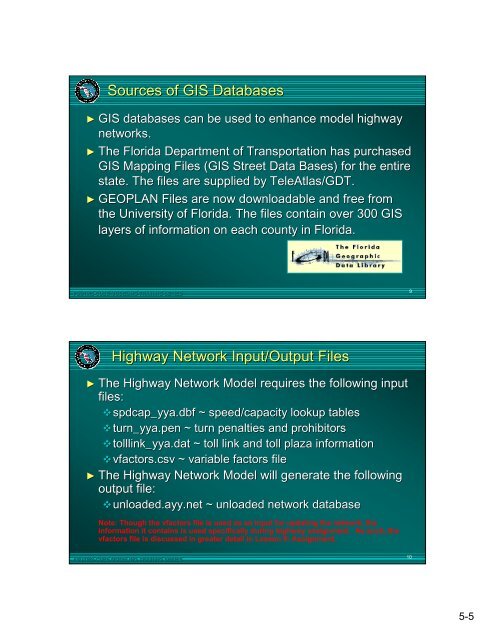
- Page 123 and 124: Overview ► The highway network mo
- Page 125: Zone Network Compatibility (Cont’
- Page 129 and 130: AT Definitions (Cont’d) ► 3x Re
- Page 131 and 132: Screenlines/Cutlines ► Screenline
- Page 133 and 134: Seasonal Factors Seasonal traffic v
- Page 135 and 136: Default Input Capacities ► Look-U
- Page 137 and 138: Speed-Capacity Table - LOS E Capaci
- Page 139 and 140: Highway Network Module Details FSUT
- Page 141 and 142: Review Highway Network Inputs Step
- Page 143 and 144: Edit Highway Network: Viewing Data
- Page 145 and 146: Edit Highway Network: Viewing Data
- Page 147 and 148: Edit Highway Network: Automatic Int
- Page 149 and 150: 1 2 FSUTMS--CUBE MODELING TRAINING
- Page 151 and 152: FSUTMS--CUBE MODELING TRAINING SERI
- Page 153 and 154: Layer Control Double-Click on BDY C
- Page 155 and 156: Overview ►The highway network pat
- Page 157 and 158: Penalties/Prohibitors Prohibitors
- Page 159 and 160: Toll Links See Data Dictionary for
- Page 161 and 162: Driving Time Driving Time In Minute
- Page 163 and 164: Interactive Path Building FSUTMS--C
- Page 165 and 166: Compute Intrazonal Times 1 Intrazon
- Page 167 and 168: Begin Exercises If you have any pro
- Page 169 and 170: Display Highway Paths (Cont’d) St
- Page 171 and 172: Modification of TOLLLINK Attributes
- Page 173 and 174: Modification of TOLLLINK Attributes
- Page 175 and 176: Summary This concludes Lesson 5. We
- Page 177 and 178:
Overview ► The Trip Distribution
- Page 179 and 180:
Gravity Model Equation T ij = P i
- Page 181 and 182:
Subarea Balancing ►Alternative to
- Page 183 and 184:
FSUTMS--CUBE MODELING TRAINING SERI
- Page 185 and 186:
Review Trip Distribution Inputs Ste
- Page 187 and 188:
1 2 3 FSUTMS--CUBE MODELING TRAININ
- Page 189 and 190:
Review Node/Point Chart Exercise 6.
- Page 191 and 192:
Review Node/Point Chart (Cont’d)
- Page 193 and 194:
FSUTMS--CUBE MODELING TRAINING SERI
- Page 195 and 196:
Creating Desire Line Maps Step 2 In
- Page 197 and 198:
End of Lesson 6 Close all files and
- Page 199 and 200:
Overview ► What is a transit netw
- Page 201 and 202:
Data Requirements ►Route line map
- Page 203 and 204:
Walk Access Links in Olympus Model
- Page 205 and 206:
Highway Network Modifications ► M
- Page 207 and 208:
FSUTMS Standards (Cont’d) Transit
- Page 209 and 210:
FSUTMS Standards (Cont’d) ► Tra
- Page 211 and 212:
FSUTMS Standards (Cont’d) ► Out
- Page 213 and 214:
Coding a Transit Line Step 1 Instru
- Page 215 and 216:
Coding a Transit Line Step 5 Instru
- Page 217 and 218:
Coding a Transit Line Step 8 Instru
- Page 219 and 220:
Coding a Transit Line Step 12 Instr
- Page 221 and 222:
Performing Transit Network/Paths St
- Page 223 and 224:
Lesson 7 - Transit Network/Paths Pa
- Page 225 and 226:
PT Best Path Pathbuilder ►Model S
- Page 227 and 228:
PT Best Path Pathbuilder ►General
- Page 229 and 230:
PT Best Path Pathbuilder ►Best Pa
- Page 231 and 232:
PT Best Path Pathbuilder ► Best P
- Page 233 and 234:
PT Best Path Pathbuilder ► Output
- Page 235 and 236:
Lesson 8 - Mode Choice Lesson Goals
- Page 237 and 238:
FSUTMS Standards ►Model Structure
- Page 239 and 240:
FSUTMS Standards ► Model Paramete
- Page 241 and 242:
Olympus Mode Choice Model Coefficie
- Page 243 and 244:
Types of Mode Choice Models ►High
- Page 245 and 246:
Highway-Only Mode Choice - Occupanc
- Page 247 and 248:
Transit Mode Choice Models Simplifi
- Page 249 and 250:
Transit Mode Choice Models ►What
- Page 251 and 252:
Lesson 8 Exercises In this exercise
- Page 253 and 254:
Run the Mode Choice Model Step 3 In
- Page 255 and 256:
Retrieve Transit Ridership by Mode
- Page 257 and 258:
Lesson 9 - Assignment Part One - Hi
- Page 259 and 260:
Overview - Equilibrium Assignment
- Page 261 and 262:
Overview - Equilibrium Assignment P
- Page 263 and 264:
FSUTMS Standards (Cont'd) ►VFACTO
- Page 265 and 266:
FSUTMS Standards (Cont'd) ►Highwa
- Page 267 and 268:
FSUTMS Standards (Cont'd) ► Seaso
- Page 269 and 270:
Displaying Results ►Mapping Loade
- Page 271 and 272:
Performing Assignment Step 1 Instru
- Page 273 and 274:
Labeling Traffic Volumes on a Map S
- Page 275 and 276:
Creating Traffic Flow Maps Step 2 I
- Page 277 and 278:
Overview ►Transit assignment mode
- Page 279 and 280:
FSUTMS Standards (Cont'd) Cube Voya
- Page 281 and 282:
FSUTMS Standards (Cont'd) ► Input
- Page 283 and 284:
Standard Results ►Reporting Trans
- Page 285 and 286:
Lesson 9, Part 2 Exercises In this
- Page 287 and 288:
Retrieve Transit Ridership Results
- Page 289 and 290:
Map Transit Boardings Step 4 Instru
- Page 291 and 292:
Summary This concludes Lesson 9. We
- Page 293 and 294:
Overview ► Post processing consis
- Page 295 and 296:
Begin Exercises If you have any pro
- Page 297 and 298:
Setting Up and Printing a Map Layou
- Page 299 and 300:
Setting Up and Printing a Map Layou
- Page 301 and 302:
Setting Up and Printing a Map Layou
- Page 303 and 304:
Lesson 11 - Advanced Tools Lesson G
- Page 305 and 306:
GIS Tools ►Overview The GIS Tools
- Page 307 and 308:
GIS Tools ►Functions (Cont’d) T
- Page 309 and 310:
Selected Link and Selected Zone Ana
- Page 311 and 312:
Scripting ►General Syntax (Cont
- Page 313 and 314:
Scripting ► Report Files A repor
- Page 315 and 316:
Begin Exercises If you have any pro
- Page 317 and 318:
Exporting a Network to a Shapefile
- Page 319 and 320:
Conduct a Selected Link Analysis Us
- Page 321 and 322:
Conduct a Selected Link Analysis Us
- Page 323 and 324:
Conduct a Selected Link Analysis Us
- Page 325 and 326:
View Turning Volumes Step 2 Instruc
- Page 327 and 328:
Create a New Application Step 1 Ins
- Page 329 and 330:
Create a New Application Step 4 Ins
- Page 331 and 332:
Create a New Application Step 6 Ins
- Page 333 and 334:
Create a New Application Step 8 Ins
- Page 335 and 336:
Lesson 12 - Traffic Impact Analysis
- Page 337 and 338:
Why Perform Traffic Impact Analysis
- Page 339 and 340:
Why Perform Traffic Impact Analysis
- Page 341 and 342:
Cordon Lines (Cont’d) DRI Zones F
- Page 343 and 344:
Differences between ITE and FSUTMS
- Page 345 and 346:
Differences between ITE and FSUTMS
- Page 347 and 348:
Special Generator Method (Cont’d)
- Page 349 and 350:
Special Generator Method (Cont’d)
- Page 351 and 352:
Link Volume Factor Method (Cont’d
- Page 353 and 354:
Link Volume Factor Method (Cont’d
- Page 355 and 356:
Land Use Conversion Rates for Traff
- Page 357 and 358:
Net Impact Method ►Not acceptable
- Page 359 and 360:
Final Considerations (Cont’d) ►
- Page 361 and 362:
DRI Exercise Step 1 Instructions: N
- Page 363 and 364:
3 1 2 FSUTMS--CUBE MODELING TRAININ
- Page 365 and 366:
Edit the Network (Cont’d) Exercis
- Page 367 and 368:
2 1 5 3 4 FSUTMS--CUBE MODELING TRA
- Page 369 and 370:
Edit the Network (Cont’d) Exercis
- Page 371 and 372:
1 3 2 5 4 9 6 7 8 FSUTMS--CUBE MODE
- Page 373 and 374:
1 5 2 4 6 3 FSUTMS--CUBE MODELING T
- Page 375 and 376:
1 4 2 3 FSUTMS--CUBE MODELING TRAIN
- Page 377 and 378:
Update the Socioeconomic Data (Cont
- Page 379 and 380:
Run the Model (Cont’d) Exercise 1
- Page 381 and 382:
Calculate Link Distribution Percent
- Page 383 and 384:
Calculate Link Distribution Percent
- Page 385 and 386:
External Cordon FSUTMS--CUBE MODELI
- Page 387:
This concludes our exercise. FSUTMS


