East Kalimantan Environmentally Sustainable Development Strategy
East Kalimantan Environmentally Sustainable Development Strategy
East Kalimantan Environmentally Sustainable Development Strategy

You also want an ePaper? Increase the reach of your titles
YUMPU automatically turns print PDFs into web optimized ePapers that Google loves.
100<br />
Exhibit 68<br />
level. Inland flooding has been a significant threat to areas such as the Mahakam delta and the<br />
capital city of Samarinda, which have substantial populations.<br />
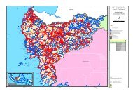
COASTAL FLOODING<br />
<strong>East</strong> <strong>Kalimantan</strong> has 194,000 ha of land that is vulnerable to coastal flooding. While sea<br />
levels are estimated to rise by 20 cm by 2030, the threat is heightened as factors such as storms and<br />
the El Nino Southern Oscillation can amplify waves and the amount of land at risk of inundation. Given<br />
these factors, land that is less than 1 meter above sea level (ASL) is typically considered vulnerable.<br />
<strong>East</strong> <strong>Kalimantan</strong> has 194,000 ha that 1 meter or less ASL. Although this represents just 1 percent<br />
of the province’s land, four districts have disproportionally greater areas at risk: Tana Tidung (10.2<br />
percent of its area is vulnerable), Samarinda (4.2 percent, although this land is more vulnerable<br />
to inland rather than coastal flooding), Bontang (3.8 percent), and Tarakan (3.6 percent). These<br />
estimates likely underestimate the threat to <strong>East</strong> <strong>Kalimantan</strong>’s coasts, though, as elevations are<br />
measured by satellite 23 which can not penetrate <strong>East</strong> <strong>Kalimantan</strong>’s dense forests. An estimate of land<br />
that is 20 meter ASL or less, while certainly an overestimate, would compensate for low elevations<br />
covered in forest and gives an upper bound of over 2 million of vulnerable lands.<br />
1% of <strong>East</strong> <strong>Kalimantan</strong>’s land is vulnerable to coastal flooding<br />
DRAFT<br />
SOURCE: Radar Topography Mission (SRTM), team analysis<br />
Penajam Paser Utara 8,459<br />
Kutai Timur 6,941<br />
Samarinda 3,033<br />
Tarakan<br />
Balikpapan<br />
Bontang<br />
Malinau<br />
Area less than 1 m ASL<br />
Ha<br />
Kutai Kertanegara 41,902<br />
Tana Tidung 34,148<br />
Bulungan 28,818<br />
Nunukan 24,540<br />
Berau 16,176<br />
Paser 14,918<br />
Kutai Barat 12,865<br />
901<br />
885<br />
613<br />
14<br />
<strong>East</strong> <strong>Kalimantan</strong> 194,213<br />
As percent<br />
of total area<br />
1.6<br />
10.2<br />
2.2<br />
1.7<br />
0.7<br />
1.4<br />
0.4<br />
2.7<br />
0.2<br />
4.2<br />
3.6<br />
1.7<br />
3.8<br />
0.0<br />
1.0<br />
Coastal flooding will have a disproportionally large economic impact on <strong>East</strong><br />
<strong>Kalimantan</strong>. Although the area that is vulnerable to coastal flooding is relatively small, it contains<br />
some of the province’s largest assets. <strong>East</strong> <strong>Kalimantan</strong>’s single international airport, Seppingan<br />
airport in Balikpapan, is on the coast and less than 1 meter ASL; Tarakan’s airport is similarly<br />
vulnerable. The multi-billion dollar LNG plant in Bontang, the single greatest capital investment in<br />
the province, is at risk. Similarly, the Pertamina refinery on the coast in Balikpapan is on vulnerable<br />
land. These two assets generated more than 27 percent of all of <strong>East</strong> <strong>Kalimantan</strong>’s GDP in 2008.<br />
23 Shuttle Radar Topography Mission (SRTM)