East Kalimantan Environmentally Sustainable Development Strategy
East Kalimantan Environmentally Sustainable Development Strategy
East Kalimantan Environmentally Sustainable Development Strategy

Create successful ePaper yourself
Turn your PDF publications into a flip-book with our unique Google optimized e-Paper software.
99<br />
predict increased precipitation for the region. There is also a weaker link between climate change<br />
and droughts although there is a link to the El Nino Southern Oscillation (which in turn is linked to<br />
the low rainfall and dramatic spread of man-made fires in 1997 and 1998 in <strong>East</strong> <strong>Kalimantan</strong>).<br />
Agricultural yields could be significantly affected. Whereas many plant species are adapted<br />
to seasonal temperature variations, tropical species typically have a much lower tolerance for<br />
changes in temperature. The World Bank predicts that by 2050 Indonesia could see a 10 percent<br />
decrease in major crop yields due to temperature and rainfall changes. Finally, vector-borne<br />
diseases can increase, as dengue- and malaria-carrying mosquitoes expand their habitats with<br />
rising temperatures. <strong>East</strong> <strong>Kalimantan</strong> currently has a low incidence of malaria; its future moderate<br />
temperature increase compared to global averages and mountainous interior (higher altitudes with<br />
lower temperatures) could serve to moderate any expansion of the habitat of vector-borne diseases.<br />
<strong>East</strong> <strong>Kalimantan</strong> has extensive coral reefs, 86 percent of which are considered at risk. 22<br />
Indonesia’s longest continuous barrier reef system, the Sunda Barrier Reef, some 630 kilometers<br />
long, lies on the edge of the Sunda Shelf. It is largely unexplored despite its size and potential<br />
economic, social, and biological importance. <strong>East</strong> <strong>Kalimantan</strong>’s coral reefs are impacted by<br />
climate change in three ways. Coral bleaching occurs during abnormally high temperatures in the<br />
ocean and kills coral if they last more than two weeks. Coral drowning occurs when coral cannot<br />
grow fast enough to keep up with rising sea levels. Oceanic acidification occurs as more CO2 is<br />
dissolved in the ocean and disturbs coral growth.<br />
However, the threats of coastal flooding and inland flooding could pose a moderate risk<br />
to the province overall and potentially substantial localized risk to specific districts.<br />
<strong>East</strong> <strong>Kalimantan</strong> has 1,185 km of coastline, 368 small islands, and several coastal cities, such as<br />
Tarakan, Bontang, and Balikpapan. While <strong>East</strong> <strong>Kalimantan</strong> is relatively protected from event-driven<br />
(or storm-driven) coastal flooding, it is susceptible to coastal flooding from gradual rises in sea<br />
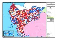
<strong>East</strong> <strong>Kalimantan</strong> climate risk landscape: Current climate risks already pose<br />
a moderate threat to people and assets<br />
Moderate risk<br />
<strong>East</strong> <strong>Kalimantan</strong> is prone to event-driven natural hazards …<br />
Coastal flooding<br />
and sea-level rise<br />
▪ <strong>East</strong> <strong>Kalimantan</strong> has a long<br />
coastline with major<br />
population centers<br />
▪ Susceptible to sea level rise<br />
▪ Strong relationship to climate<br />
change<br />
Storms<br />
▪ <strong>East</strong> <strong>Kalimantan</strong> is away from<br />
major tropical cyclone tracks, due<br />
to close proximity to the Equator<br />
(storms typically originate > 10 o )<br />
DRAFT<br />
Inland flooding<br />
▪ El Niño Southern Oscillation<br />
and rainfall are strong<br />
drivers<br />
▪ Flooding in Samarinda<br />
▪ Moderate link with climate<br />
change<br />
Malinau<br />
Region<br />
Nunukan<br />
Region<br />
Berau<br />
Region<br />
Kutai Timur<br />
Region<br />
Drought<br />
▪ Low historical incidence<br />
outside; but increased fires of<br />
1997-98 linked to El Nino<br />
▪ Linked to ENSO, but weak<br />
climate change link<br />
Tarakan<br />
Bulungan Region<br />
… and also faces hazards from<br />
gradual climate change shifts<br />
Malaria and vectorborne<br />
diseases<br />
▪ Increasing temperature and<br />
rainfall are largely accepted<br />
as factors that increase<br />
malaria infection rates<br />
Agriculture yield<br />
change<br />
▪ Agriculture is 5% of GDP but<br />
important in rural areas<br />
▪ World Bank predicts yields<br />
could be negatively impacted<br />
by 10% in Indonesia due to<br />
climate change<br />
Exhibit 67<br />
Landslides<br />
▪ <strong>East</strong> <strong>Kalimantan</strong> has low<br />
incidence of landslides<br />
compared to Java or Sumatra<br />
▪ Linked to rainfall intensity and<br />
land use<br />
Kutai<br />
Barat<br />
Region<br />
Bontang<br />
Samarinda<br />
Kutai Kartanegara Region<br />
Balikpapan<br />
Penajam PU Region<br />
Pasir Region<br />
Damage to coral<br />
reefs<br />
▪ Source of livelihood<br />
(fisheries, tourism, etc.) and<br />
natural barrier of protection<br />
▪ Coral is killed by bleaching,<br />
drowning, and acidification,<br />
linked to climate<br />
SOURCE: EM-DAT;<strong>East</strong> <strong>Kalimantan</strong> in Statistics BPS; press clippings; interviews; academic literature<br />
22 Based on Indonesia’s overall average as estimated by Reefs at Risks.