East Kalimantan Environmentally Sustainable Development Strategy
East Kalimantan Environmentally Sustainable Development Strategy
East Kalimantan Environmentally Sustainable Development Strategy

You also want an ePaper? Increase the reach of your titles
YUMPU automatically turns print PDFs into web optimized ePapers that Google loves.
41<br />
after the identified abatement measures and policies are implemented. Locating any processing<br />
unit near palm oil concessions on degraded lands will also help as transportation costs will favor<br />
the closest concessions as sources. Finally, requiring the downstream processing facilities to use<br />
only certified sustainable palm oil (RSPO) can mitigate these risks (Box 2).<br />
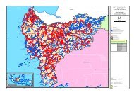
<strong>East</strong> <strong>Kalimantan</strong> needs to improve its infrastructure to attract<br />
downstream investment<br />
SOURCE: ICF, team analysis<br />
100 km haulage distance around ports<br />
100 km haulage distance around ports<br />
with CPO handling capacity<br />
▪ Existing road network has to<br />
be expanded to speed<br />
transportation of CPO to<br />
coastal refineries<br />
▪ Additional seaports with<br />
CPO handling capabilities<br />
are needed as currently<br />
they only exist in Balikpapan<br />
and Bontang<br />
▪ Additional port facilities on<br />
the major rivers have to be<br />
considered to allow CPO<br />
refining in the interior<br />
Required Policies and Institutions<br />
Implementing these initiatives to reduce emissions and improve the growth of palm<br />
oil will require substantial changes from business-as-usual practices. Four institutional<br />
and policy reforms will be critical for capturing the abatement potential from the palm oil sector<br />
(EXHIBIT 20).<br />
DRAFT<br />
Holistic and integrated spatial planning is needed to optimize land use for palm oil.<br />
The existing spatial planning approach of <strong>East</strong> <strong>Kalimantan</strong> does not take into account climate<br />
change or ecological criteria. For example, forested areas are allocated to non-forestry use (Areal<br />
Penggunaan Lain, APL), while large areas of degraded land within the forest estate (kawasan<br />
hutan) are officially designated (and therefore managed) as permanent forest areas. Going forward,<br />
a broader spatial planning approach is required that incorporates environmental, economic, and<br />
social factors. The main goal for the new spatial planning approach should be to identify degraded<br />
areas (including the size of the area, soil type and suitability for different land uses, land ownership,<br />
and current land use) outside and inside the forest estate. This will enable the prioritized use of<br />
degraded land for economic development. The permanent forest estate should comprise actual<br />
remaining forests. Spatial planning consequently has to happen in much closer cooperation<br />
between the local planning agency (Bappeda), the Indonesian Ministry of Forestry, and local<br />
communities. The inclusion of local communities in the overall spatial and economic planning<br />
process has to follow a set of standards known as free, prior, and informed consent (FPIC). This<br />
approach has been developed to respect the rights of indigenous communities and can help<br />
reduce or prevent social conflicts related to land use in an area.<br />
Exhibit 19