Indigenous Peoples and Conservation Organizations
Indigenous Peoples and Conservation Organizations
Indigenous Peoples and Conservation Organizations

You also want an ePaper? Increase the reach of your titles
YUMPU automatically turns print PDFs into web optimized ePapers that Google loves.
94 The Foi in Papua New Guinea<br />
In general, they want project activities to generate<br />
cash income <strong>and</strong> improve access to basic<br />
services. The resources they own, particularly<br />
the forests, are perceived to be the sole means of<br />
achieving these goals. Therefore, they are<br />
extremely vulnerable to timber companies that<br />
employ devious means to lure l<strong>and</strong>holders into<br />
contracts for industrial logging. For many communities,<br />
logging has become almost synonymous<br />
with development.<br />
III. Lake Kutubu <strong>and</strong> Sustainable<br />
Resource Management<br />
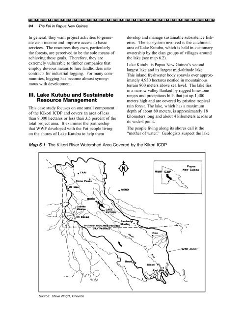
This case study focuses on one small component<br />
of the Kikori ICDP <strong>and</strong> covers an area of less<br />
than 8,000 hectares or less than 3.5 percent of the<br />
total project area. It examines the partnership<br />
that WWF developed with the Foi people living<br />
on the shores of Lake Kutubu to help them<br />
develop <strong>and</strong> manage sustainable subsistence fisheries.<br />
The ecosystem involved is the catchment<br />
area of Lake Kutubu, which is held in customary<br />
ownership by the clan groups of villages around<br />
the lake (see map 6.2).<br />
Lake Kutubu is Papua New Guinea’s second<br />
largest lake <strong>and</strong> its largest mid-altitude lake.<br />
This inl<strong>and</strong> freshwater body sprawls over approximately<br />
4,930 hectares nestled in mountainous<br />
terrain 800 meters above sea level. The lake lies<br />
in a narrow valley flanked by rugged limestone<br />
ranges <strong>and</strong> precipitous hills that jut up 1,400<br />
meters high <strong>and</strong> are covered by pristine tropical<br />
rain forest. The lake, which has a maximum<br />
depth of about 80 meters, is approximately 18<br />
kilometers long <strong>and</strong> about 4 kilometers across at<br />
its widest point.<br />
The people living along its shores call it the<br />
“mother of water.” Geologists suspect the lake<br />
Map 6.1 The Kikori River Watershed Area Covered by the Kikori ICDP<br />
Source: Steve Wright, Chevron