- Page 2 and 3:
MATHEMATICS INSCIENCE AND SOCIETYPl
- Page 4 and 5:
DIDACTICSTEACHING FOR TRANSFERthan
- Page 6 and 7:
DIDACTICSTEACHING FOR TRANSFEREmpha
- Page 8 and 9: DIDACTICSTEACHING FOR TRANSFER1. Wh
- Page 10 and 11: DIDACTICSTEACHING FOR TRANSFER14. I
- Page 12 and 13: DIDACTICSTEACHING VIA PROBLEM SOLVI
- Page 14 and 15: DIDACTICSTEACHING VIA PROBLEM SOLVI
- Page 16 and 17: DIDACTICSTEACHING VIA PROBLEM SOLVI
- Page 18 and 19: DIDACTICSTEACHING VIA PROBLEM SOLVI
- Page 20 and 21: DIDACTICSTEACHING VIA PROBLEM SOLVI
- Page 22 and 23: DIDACTICSTEACHING VIA PROBLEM SOLVI
- Page 24 and 25: DIDACTICSTEACHING VIA PROBLEM SOLVI
- Page 26 and 27: DIDACTICSTEACHING VIA PROBLEM SOLVI
- Page 28 and 29: DIDACTICSTEACHING VIA PROBLEM SOLVI
- Page 30 and 31: (((
- Page 32 and 33: MATHEMATICS INSCIENCE AND SOCIETYPl
- Page 34 and 35: DIDACTICSTEACHING VIA LAB APPROACHE
- Page 36 and 37: DIDACTICSTEACHING VIA LAB APPROACHE
- Page 38 and 39: DIDACTICSTEACHING VIA LAB APPROACHE
- Page 40 and 41: DIDACTICSTEACHING VIA LAB APPROACHE
- Page 42 and 43: DIDACTICSTEACHING VIA LAB APPROACHE
- Page 44 and 45: DIDACTICSTEACHING VIA LAB APPROACHE
- Page 46 and 47: DIDACTICSTEACHING VIA PROELEM SOLVI
- Page 48 and 49: INTRODUCTIONMATHEMATICS AND ASTRONO
- Page 50 and 51: (TITLEPAGETOPICMATHTYPEMaking Waves
- Page 52 and 53: We all know that the Sun gives off
- Page 54 and 55: TRACK RECORDS IN SPACE??? ---YOU WI
- Page 56 and 57: MEA8UI2\NG BYTf2IAtJGULAlI0NHow can
- Page 60 and 61: Over 2,000 years ago a Greek scient
- Page 62 and 63: ,~ THE SUNWITt-UN RANGE? (Can a hom
- Page 64 and 65: \g THE SUNWITHIN QANGE?(PM€: 3)(\
- Page 66 and 67: Repeat with your left eye,being car
- Page 68 and 69: (4. Because distances to the stars
- Page 70 and 71: (Astronomers are able to construct
- Page 72 and 73: . Mars orbits the Sun in 687 days,
- Page 74 and 75: f(ILR HUGS·CHUNK:. OF CH£ESED.("O
- Page 76 and 77: R HUGE"CHUNKo. OF CHEESE}).(PAGE: '
- Page 78 and 79: In A Huge Chunk of Cheese studentso
- Page 80 and 81: THATS A MODELI CAN I2.ELATE TO(cot-
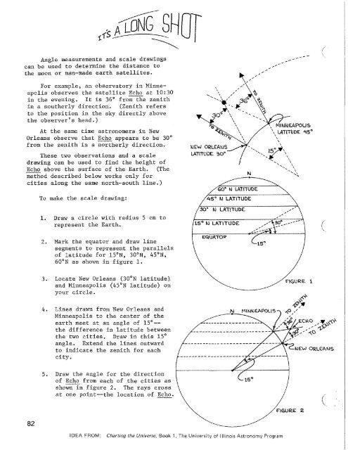
- Page 82 and 83: t~£p'KEPLER- DIDNTGO AeOUNDIN CU2C
- Page 84 and 85: .Kep!eys seconcfJa11lTycho's data o
- Page 86 and 87: (Kepler was not content with his fi
- Page 88 and 89: How fast is each planet traveling i
- Page 90 and 91: COMETS ANDCONIC5 ECTIQt\l5(From Kep
- Page 92 and 93: COMETS ANDCONICSECtIONS(PAGE. 3)2)
- Page 94 and 95: Study figure 3.Tl--4EZOD~A~(CmlTII0
- Page 96 and 97: 1TI S1r)l~ti~~~~~v~~( COIJTIIJUED)(
- Page 98 and 99: ASTRONOMY GLOSSARY cir-mercircumpol
- Page 100 and 101: ASTRONOMYGLOSSARYtan~zodtangent. Tw
- Page 102 and 103: (((
- Page 104 and 105: INTRODUCTION MATHEMATICS AND BIOLOG
- Page 106: TITLE PAGE TOPIC MATH TYPEI See It
- Page 111 and 112:
liNIl N"MAN•••y(COIJTllJUED)P
- Page 113 and 114:
III.Between the ages of 2 and 4 a c
- Page 115 and 116:
HOW'S YOUeFor this activity you nee
- Page 117 and 118:
Two activities are outlined below t
- Page 119 and 120:
By yourself or with a friendbeats i
- Page 121 and 122:
Numerous ads to eat wisely and exer
- Page 123 and 124:
,,/The information gained from this
- Page 125 and 126:
Spy ON THE EYEMaterials Needed:Cloc
- Page 127 and 128:
GAININ.OQLOSING ()J{f:f!f3Students
- Page 129 and 130:
GAl.I•• ORLO SING(J;fj'ff3(PAGE
- Page 131 and 132:
1'751'70ISI;jlIGOwQ( 155t;:;;: 150i
- Page 133 and 134:
GAI.I•• oRLOSING ~(PAGE. 7)The
- Page 135 and 136:
BODY COUNTI NG SYSTE~1SBODY COUNTIN
- Page 137 and 138:
Materials Needed:Centimetre cubesAc
- Page 139 and 140:
Materials Needed:Centimetre cubesAc
- Page 141 and 142:
The physical traits that an individ
- Page 143 and 144:
ANALYZINGTRAITSThe following are so
- Page 145 and 146:
ANALYZ1NGTRAITS(PAGE 3)c) hitchhike
- Page 147 and 148:
WffAT TVPEAilE YOII ?Blood type fal
- Page 149 and 150:
JUST LIKE PEAS'NA~ODThe science of
- Page 151 and 152:
C£OJSA2Yalleles. Parts of genes. O
- Page 153 and 154:
to MATHEMATICS AND ENVIRONMENTEnvir
- Page 155 and 156:
Students will often be more interes
- Page 157 and 158:
Use Student Pages and Project Ideas
- Page 159 and 160:
Encircle all mathematical andhorizo
- Page 161 and 162:
[OMPUTCQC DNDTUb bNVIODNMbNTCompute
- Page 163 and 164:
COJIT&nJTSTITLE PAGE TOPIC MATH TYP
- Page 165 and 166:
TITLE PAGE TOPIC MATH TYPEMATHEMATI
- Page 167 and 168:
PDPUL~TIDNb6TIMQTIDN1) Estimate the
- Page 169:
The students build a model which sh
- Page 172 and 173:
DOUBLING 24816(When numbers keep do
- Page 174 and 175:
(1) Some people don't have children
- Page 176 and 177:
COUNTINGEVERY BODY219®oot;t-::W WZ
- Page 178 and 179:
(/... ....: ..,.. ..." tr ......I \
- Page 180 and 181:
(1. Find which city has the fastest
- Page 182 and 183:
c((
- Page 184:
(Sometimes wildlife specialists wan
- Page 188 and 189:
(1) Farmers in the U.S. have been d
- Page 190 and 191:
(Write or call the nearest air poll
- Page 192 and 193:
Suppose you, or someone you know, i
- Page 194 and 195:
))JFO~MA1[ON:dee poccurlON ( ,1) Ev
- Page 196 and 197:
"' ':,~'~:,':>' ," ..~ '. ,": ~ ; .
- Page 198 and 199:
,/(Make plans to take a poll of 50
- Page 200 and 201:
(\((
- Page 202 and 203:
Water is needed to grow food and to
- Page 204 and 205:
.. .'., .· ',.;,' .(EVAPORATIOr-lt
- Page 206 and 207:
(1. Is there water pollution in you
- Page 209 and 210:
~ EEB""'-'~~wlci~X~;l\~J;;~i;lf,ki.
- Page 211 and 212:
Students in one class at Washington
- Page 213 and 214:
Major efforts to recycle materialsl
- Page 215 and 216:
l=OUQRl;[YCLING~[TIVITI{;51. Find o
- Page 217 and 218:
DID YOUKNON?Here is a sample page y
- Page 219 and 220:
SOURCES OF ENERGY FOR THE U.S.In 18
- Page 221 and 222:
269-/ I ----=---::--~::::::=~...l30
- Page 223 and 224:
i/' /CE' I~ 0~,~.~ ~'~ f.M .. cOmH~
- Page 225 and 226:
----1) A bicycle can go 18 km/h. Ho
- Page 227 and 228:
C£OJSARYaerosol. A mixture of tiny
- Page 229 and 230:
ENVIRONMENT GLOSSARYsymbolsSymboZse
- Page 231 and 232:
SOURCESENVIRONMENTPhiladelphia, PA
- Page 233 and 234:
;to MATHEMATICS ANV MUSICIt is said
- Page 235 and 236:
INTRODUCTIONMATHEMATICS AND MUSICMa
- Page 237 and 238:
particularlyhelpful during individu
- Page 239 and 240:
MATHEMATICS ANDMUSICTITLEPAGETOPICM
- Page 241 and 242:
TITLEPAGETOPICMATHTYPEMod Compositi
- Page 243 and 244:
UseThe general questions asked on t
- Page 245 and 246:
The following are additional activi
- Page 247 and 248:
Materials Needed:Dtt=b¥fieve jV) m
- Page 249 and 250:
Time lines can help students seG wh
- Page 251 and 252:
4)THE ~nlJ§I[~RIKEi(CO"lTI~UW )Wha
- Page 253 and 254:
INsTQUMt;NTSWIT~(PAGe 2.)[LRSSHave
- Page 255 and 256:
INSTRUMtNT~WIT~(PAQ£ 4)[LRSSPIANOS
- Page 257 and 258:
I. Teacher Introduction to Game: Us
- Page 259 and 260:
Playing board withInstrument cardsA
- Page 261 and 262:
NOT£S,~£STS~~~ r~f1CrIOrYSFractio
- Page 263 and 264:
grCtNTtNNIRL8tRTOne or two notes ar
- Page 265 and 266:
RID THE BERTCO[5 ONwhole
- Page 267 and 268:
EACH SYMBOL GIVES A HINT FOR A MISS
- Page 269 and 270:
BACKGROUND:Motions in geometry can
- Page 271 and 272:
I. • .. .]MDVb:MbNT~IQ~T{(~((({«
- Page 273 and 274:
This set of notes has beentranslate
- Page 275 and 276:
TWIRD MDVbMbNT~T~Each of thesemeasu
- Page 277 and 278:
FINRLE:VQOIQTIDNCIt would be intere
- Page 279 and 280:
Materials: Written music with a def
- Page 281 and 282:
The next step in the process is mos
- Page 283 and 284:
BACKGROUND:»LJJ:::J'~:.,:: ~.:..,
- Page 285 and 286:
I.t:j: Question:RN ORDERL YRRRRNbtM
- Page 287 and 288:
III.THETW~LVt- TONtMET~DO(PAC,E. 2)
- Page 289 and 290:
Musical tones sound different whent
- Page 291 and 292:
The chart below gives the range in
- Page 293 and 294:
Sound is caused by a vibrating obje
- Page 295 and 296:
6. The relative intensity column is
- Page 297 and 298:
1. Here are levels of loudness that
- Page 299 and 300:
Decibel readers are small electroni
- Page 301 and 302:
C£OJSA2Yaceidentals. Musical symbo
- Page 303 and 304:
MUSIC GLOSSARYoct-stroctave. An int
- Page 305 and 306:
to MATHEMATICS ANDPHYSICSNatural in
- Page 307 and 308:
MATHEMATICS AND PHYSICSTITLEPAGETOP
- Page 309 and 310:
SUPPORTMaterials:Metre stick,2 magn
- Page 311 and 312:
AIRThe vast ocean of air above us e
- Page 313 and 314:
-=-RSWINGINGTIME(COtJTII\lUED)III U
- Page 315 and 316:
Materials Needed:paperHang a rubber
- Page 317 and 318:
PLANKMaterials Needed:Long plank ab
- Page 319 and 320:
341
- Page 321 and 322:
CO\\lTlI\lUED)F) As the cart is pul
- Page 323 and 324:
Materials Needed: One Celsius therm
- Page 325 and 326:
The distance a person can see on th
- Page 327 and 328:
In 250 B.C. Archimedes knew that an
- Page 329 and 330:
~~Jt~y RNDHALF-LIFE.(CONTltJUED)IVV
- Page 331 and 332:
The half-life of a radioactive subs
- Page 333 and 334:
fH;-7~J##A/Hrp£fg-:Z5V£.§M-Z-E.7
- Page 335 and 336:
®RtFlECTIONS(CONT)0,0,®D®®2~OIT
- Page 337 and 338:
Materials Needed: straight pins,sma
- Page 339 and 340:
MllUllllllPlllE[J~EFl E[ 1111[]IINI
- Page 341 and 342:
IISome exact measurements.Geometric
- Page 343 and 344:
BENDING OF LIGHTk7[~(7?7CrIaNLight
- Page 345 and 346:
BENDING OF LIGHl=(7[(?1?l[rIL7NWhen
- Page 347 and 348:
C£OJSARYbarometer. An instrument f
- Page 349 and 350:
:to MATHEMATICS AND SPORTSA 22-poun
- Page 351 and 352:
Use Newspapers and MagazinesSave cl
- Page 353 and 354:
Page 6C REGISTER-GUARD, Eugene, Ore
- Page 355 and 356:
(PAGE: 5)TENNIS BAllSYellow or whit
- Page 357 and 358:
CONJEflTSMATHEMATICS AND SPORTSTITL
- Page 359 and 360:
TITLEPAGETOPICMATHTYPEFootball Inju
- Page 361 and 362:
1. The following activity deals wit
- Page 363 and 364:
R '1Check the time distance ot each
- Page 365 and 366:
Which ball bounces the highest?Mate
- Page 367 and 368:
5ItR5E5Mateh up the following balls
- Page 369 and 370:
The volume formula for a sphere (ba
- Page 371 and 372:
PERSONAL RECORDS OF CLASSROOM DECAT
- Page 373 and 374:
Get your measurements for the follo
- Page 375 and 376:
w= ~-My HEARTTHRO S~12. Yo~Material
- Page 377 and 378:
III.(CONTll\IU..D)Simplified Pulse
- Page 379 and 380:
Estimate the number of hours (to th
- Page 381 and 382:
BOYSSITUPSA pupil lies on his backa
- Page 383 and 384:
BOYSSOFTBALL THR0\4A softball is th
- Page 385 and 386:
~JbW~ [MJ~ ~ rnJ~OO[QJ ~uillJ~uA mo
- Page 387 and 388:
WORLD TRACK RECORDS-FIELD EVENTS-HI
- Page 389 and 390:
HOW THE WORLD RECORD PROGRESSED100
- Page 391 and 392:
S[DRt~ttPINbIN BDWLINbC15=JIn bowli
- Page 393 and 394:
81:To find a baseball player's slug
- Page 395 and 396:
Each week during the I6otball)~~aso
- Page 397 and 398:
1. A. What part ofthe body sustaine
- Page 399 and 400:
To determine the score in shufflebo
- Page 401 and 402:
famou, f)lack Ameflcan,PuzzleThough
- Page 403 and 404:
BACK.COURTThe diagram to the leftis
- Page 405 and 406:
The table below gives the number of
- Page 407 and 408:
••••• ~~..... _ ...._ •
- Page 409 and 410:
C£OJSARVat bat. In baseball the nu
- Page 411 and 412:
ANNOTATE" BZKZOCIl4lPWThe following
- Page 413 and 414:
BIBLIOGRAPHYMATHEMATICS IN SCIENCE
- Page 415 and 416:
BIBLIOGRAPHY MATHEMATICS IN SCIENCE
- Page 417 and 418:
BIBLIOGRAPHY MATHEMATICS IN SCIENCE
- Page 419 and 420:
BIBLIOGRAPHY MATHEMATICS IN SCIENCE
- Page 421 and 422:
BIBLIOGRAPHY MATHEMATICS IN SCIENCE
- Page 423 and 424:
BIBLIOGRAPHY MATHEMATICS IN SCIENCE
- Page 425 and 426:
BIBLIOGRAPHY MATHEMATICS IN SCIENCE
- Page 427 and 428:
BIBLIOGRAPHY MATHEMATICS IN SCIENCE
- Page 429 and 430:
BIBLIOGRAPHY MATHEMATICS IN SCIENCE
- Page 431 and 432:
BIBLIOGRAPHY MATHEMATICS IN SCIENCE
- Page 433 and 434:
BIBLIOGRAPHY MATHEMATICS IN SCIENCE
- Page 435 and 436:
BIBLIOGRAPHY MATHEMATICS IN SCIENCE
- Page 437 and 438:
Page Number78 (1) noon; sunrise or
- Page 439 and 440:
Page Number310311313314(VII) B is A
- Page 441 and 442:
Page Number289 square, trouble, tie
- Page 443 and 444:
Page Number216 (1) .84 (2) 153 mill