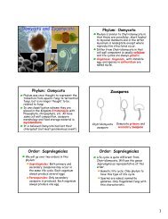
american samoa - University of Hawaii at Manoa Botany Department
american samoa - University of Hawaii at Manoa Botany Department
american samoa - University of Hawaii at Manoa Botany Department
- No tags were found...

You also want an ePaper? Increase the reach of your titles
YUMPU automatically turns print PDFs into web optimized ePapers that Google loves.
A 75-foot reach <strong>of</strong> rock-filled gabions was observed along the east side <strong>of</strong> Asili Stream nearst<strong>at</strong>ion 9+00. Five gabion baskets were also documented in the vicinity <strong>of</strong> st<strong>at</strong>ion 6+00 alongthe east side <strong>of</strong> the stream. Both sets <strong>of</strong> gabions were apparently constructed by residents tohelp prevent flooding from higher stream flows.Past flooding in the vicinity <strong>of</strong> st<strong>at</strong>ion 4+00 was reported by one resident who recalled theflooding <strong>of</strong> one guest fale along the west bank <strong>of</strong> the stream (Maugaotega, 1999). Erosion <strong>of</strong>the stream bank was also evident in this loc<strong>at</strong>ion.Stream FlowsHistorical Stream FlowsThree stream gages have historically been established by the U.S. Geological Survey <strong>at</strong> variouspoints along Asili Stream (Table 10-1). The d<strong>at</strong>a gained from these stream gages provide aninsight <strong>of</strong> historical stream flows along Asili Stream.Between 1977 and 1986, a continuous-record gage (No. 16931500) was established <strong>at</strong> the 330-foot elev<strong>at</strong>ion. These measurements enabled USGS to calcul<strong>at</strong>e an estim<strong>at</strong>ed median flow <strong>of</strong>1.60 cubic feet per second (cfs).The same gage was oper<strong>at</strong>ed as a partial-record site between 1987 and 1990. Extreme flowsrecorded during this period included a maximum discharge <strong>of</strong> 653 cfs on October 28, 1960 anda minimum <strong>of</strong> 0.20 cfs on August 6, 1983.Another partial record st<strong>at</strong>ion (No. 16932500) was oper<strong>at</strong>ed 100 feet upstream from the Route1 bridge between 1959 and 1990. D<strong>at</strong>a gener<strong>at</strong>ed from 34 measurements <strong>of</strong> stream flow wereused by USGS to estim<strong>at</strong>e a median stream flow <strong>of</strong> 2.85 cfs (Wong, 1996).Various other one to two-day measurements <strong>of</strong> stream flow were made by USGS <strong>at</strong> variouspoints along Asili Stream. This d<strong>at</strong>a is not presented since more reliable d<strong>at</strong>a was obtainedfrom the three other stream gages (Table 10-1).TABLE 10-1MEDIAN STREAM FLOW ESTIMATEASILI STREAMUSGSGage St<strong>at</strong>ionGage Loc<strong>at</strong>ion16931500 0.8 mile upstream from streammouth <strong>at</strong> the 330-footelev<strong>at</strong>ion.16932000 0.5 mile upstream from theAsili Stream mouth.16932500 100 feet upstream <strong>of</strong> Route 1bridge.Source: Wong, 1996Stream FlowMeasurements(number)Continuously recordedbetween 1977-1986Estim<strong>at</strong>ed MedianFlow (cfs)1.6024 1.8534 2.85American Samoa Wetlands/Streams Restor<strong>at</strong>ion and Enhancement PlanFebruary 2001, Asili Stream, Page 10-4