

SCHRIFTENREIHE Institut für Pflanzenernährung und Bodenkunde ...
SCHRIFTENREIHE Institut für Pflanzenernährung und Bodenkunde ...
SCHRIFTENREIHE Institut für Pflanzenernährung und Bodenkunde ...

Create successful ePaper yourself
Turn your PDF publications into a flip-book with our unique Google optimized e-Paper software.
32<br />
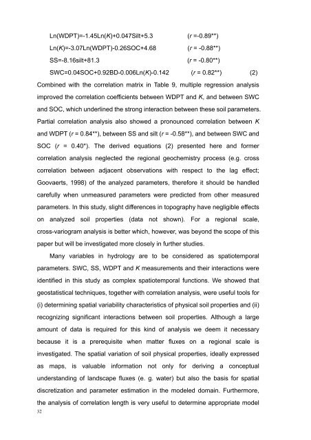
Ln(WDPT)=-1.45Ln(K)+0.047Silt+5.3 (r =-0.89**)<br />
Ln(K)=-3.07Ln(WDPT)-0.26SOC+4.68 (r = -0.88**)<br />
SS=-8.16silt+81.3 (r = -0.80**)<br />
SWC=0.04SOC+0.92BD-0.006Ln(K)-0.142 (r = 0.82**) (2)<br />
Combined with the correlation matrix in Table 9, multiple regression analysis<br />
improved the correlation coefficients between WDPT and K, and between SWC<br />
and SOC, which <strong>und</strong>erlined the strong interaction between these soil parameters.<br />
Partial correlation analysis also showed a pronounced correlation between K<br />
and WDPT (r = 0.84**), between SS and silt (r = -0.58**), and between SWC and<br />
SOC (r = 0.40*). The derived equations (2) presented here and former<br />
correlation analysis neglected the regional geochemistry process (e.g. cross<br />
correlation between adjacent observations with respect to the lag effect;<br />
Goovaerts, 1998) of the analyzed parameters, therefore it should be handled<br />
carefully when unmeasured parameters were predicted from other measured<br />
parameters. In this study, slight differences in topography have negligible effects<br />
on analyzed soil properties (data not shown). For a regional scale,<br />
cross-variogram analysis is better which, however, was beyond the scope of this<br />
paper but will be investigated more closely in further studies.<br />
Many variables in hydrology are to be considered as spatiotemporal<br />
parameters. SWC, SS, WDPT and K measurements and their interactions were<br />
identified in this study as complex spatiotemporal functions. We showed that<br />
geostatistical techniques, together with correlation analysis, were useful tools for<br />
(i) determining spatial variability characteristics of physical soil properties and (ii)<br />
recognizing significant interactions between soil properties. Although a large<br />
amount of data is required for this kind of analysis we deem it necessary<br />
because it is a prerequisite when matter fluxes on a regional scale is<br />
investigated. The spatial variation of soil physical properties, ideally expressed<br />
as maps, is valuable information not only for deriving a conceptual<br />
<strong>und</strong>erstanding of landscape fluxes (e. g. water) but also the basis for spatial<br />
discretization and parameter estimation in the modeled domain. Furthermore,<br />
the analysis of correlation length is very useful to determine appropriate model