- Page 1 and 2: 2012s5947 South WorcestershireStrat
- Page 4 and 5: ContractThis Level 2 Strategic Floo
- Page 6: Executive SummaryThis report is an
- Page 10 and 11: Table 7-16: SWDP8/1 (Broomhall Comm
- Page 12 and 13: NRDOrdinary WatercourseOS NGRPFRAPi
- Page 14 and 15: identify the level of detail requir
- Page 16 and 17: 1.4 Approach1.4.1 General Assessmen
- Page 18 and 19: 1.5.3 Severn Trent WaterSevern Tren
- Page 20 and 21: 2 The Planning Framework and Flood
- Page 22 and 23: Additionally Provision 110 of the A
- Page 24 and 25: Risk ManagementAuthority (RMA)Distr
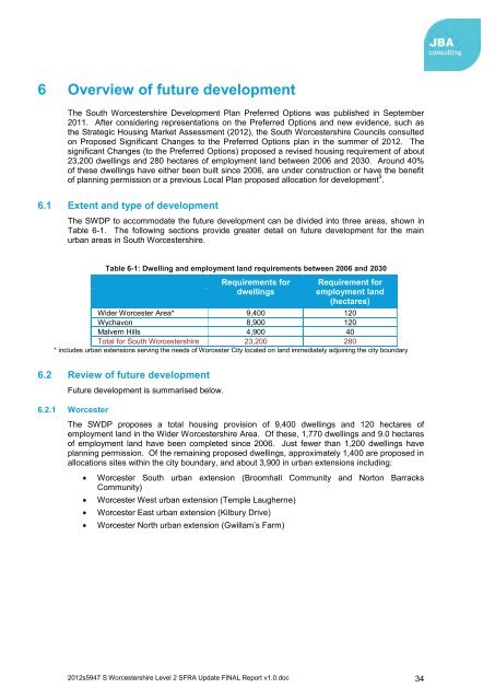
- Page 26 and 27: 3 Understanding Flood Risk in South
- Page 28 and 29: earth embankment, flood wall and fl
- Page 30 and 31: 4 How Flood Risk is Assessed4.1 Def
- Page 32 and 33: Zone 1Zone 2Zone 3aZone 3bTable 4-1
- Page 34 and 35: etween the proposed level of commit
- Page 36 and 37: 5 Mapping and risk based approach5.
- Page 38 and 39: The ability to manage flood risk fo
- Page 40 and 41: Stage 3 - Applying the Sequential T
- Page 44 and 45: A proposed 340 dwelling have been a
- Page 46 and 47: Figure 6-5: Proposed Pershore Alloc
- Page 48 and 49: 6.3 Windfall sitesWindfall is unall
- Page 50 and 51: 7 Summary assessment of SWDP develo
- Page 52 and 53: SUDS TypeSource ControlsTable 7-2:
- Page 54 and 55: 7.4 Summary tables and mapsTable 7-
- Page 56 and 57: SUDS and the development site:SUDS
- Page 58 and 59: Sources of Flood Risk:Primary flood
- Page 60 and 61: Table 7-5: LP1 (Ivy Lane)OS NGR: SP
- Page 62 and 63: SUDS and the development site:SUDS
- Page 64 and 65: Sources of Flood Risk:Primary flood
- Page 66 and 67: Table 7-7: 2012SC (Stonebridge Cros
- Page 68 and 69: SUDS and the development site:SUDS
- Page 70 and 71: Sources of Flood Risk:Primary flood
- Page 72 and 73: emergence. Further assessment of gr
- Page 74 and 75: Sources of Flood Risk:Primary flood
- Page 76 and 77: Table 7-10: SWDP6/NEWJ (Land North
- Page 78 and 79: Estimated Attenuation Storage Volum
- Page 80 and 81: Sources of Flood Risk:Primary flood
- Page 82 and 83: Table 7-12: SWDP6/6 (Old Northwick
- Page 84 and 85: Soil TypeGreenfield Runoff Rate (l/
- Page 86 and 87: Sources of Flood Risk:Surface water
- Page 88 and 89: Table 7-14: SWDP6/21 (Former Hallow
- Page 90 and 91: SUDS and the development siteSUDS T
- Page 92 and 93:
Sources of Flood Risk:Primary flood
- Page 94 and 95:
Table 7-16: SWDP8/1 (Broomhall Comm
- Page 96 and 97:
Surface water presents a risk to th
- Page 98 and 99:
Table 7-17: SWDP8/2 (Temple Laugher
- Page 100 and 101:
A44 Bromyard road, the A4440 Grove
- Page 102 and 103:
Table 7-18: SWDP8/3 (Land to the re
- Page 104 and 105:
impermeable surfaces may result in
- Page 106 and 107:
Table 7-19: SWDP9/2 (Land east of S
- Page 108 and 109:
impermeable surfaces may result in
- Page 110 and 111:
Table 7-20: SWDP9/3 (Boxing Club)OS
- Page 112 and 113:
Estimated Attenuation Storage Volum
- Page 114 and 115:
Sources of Flood Risk:Primary flood
- Page 116 and 117:
Table 7-22: SWDP9/7 (Canal Basin Pr
- Page 118 and 119:
Soil TypeGreenfield Runoff Rate (l/
- Page 120 and 121:
Sources of Flood Risk:The main sour
- Page 122 and 123:
Table 7-24: SWDP13/4 (Former playin
- Page 124 and 125:
Surface Water Drainage:As an indica
- Page 126 and 127:
Table 7-25: SWDP13/5 (Former Recrea
- Page 128 and 129:
Surface Water Drainage:As an indica
- Page 130 and 131:
Table 7-26: SWDP13/9 (Land off Mayf
- Page 132 and 133:
Greenfield Runoff Rate (l/s/ha)Esti
- Page 134 and 135:
Sources of Flood Risk:Primary flood
- Page 136 and 137:
eceiving watercourse to ensure flow
- Page 138 and 139:
Sources of Flood Risk:The main sour
- Page 140 and 141:
Table 7-29: SWDP18/6 Land rear of t
- Page 142 and 143:
Estimated Attenuation Storage Volum
- Page 144 and 145:
Sources of Flood Risk:Primary flood
- Page 146 and 147:
New or re-development should adopt
- Page 148 and 149:
Sources of Flood Risk:Primary flood
- Page 150 and 151:
Table 7-32: SWDP23/26 (Land between
- Page 152 and 153:
Estimated Attenuation Storage Volum
- Page 154 and 155:
Sources of Flood Risk:The main sour
- Page 156 and 157:
Table 7-34: SWDP24/8 (Site behind H
- Page 158 and 159:
SUDS and the development site:SUDS
- Page 160 and 161:
Sources of Flood Risk:Primary flood
- Page 162 and 163:
Table 7-36: SWDP24/11 (Site behind
- Page 164 and 165:
overtopping of an unnamed tributary
- Page 166 and 167:
Table 7-37: SWDP24/13 (Land east of
- Page 168 and 169:
Estimated Attenuation Storage Volum
- Page 170 and 171:
Sources of Flood Risk:Primary flood
- Page 172 and 173:
Table 7-39: SWDP25/9 (Land at Park
- Page 174 and 175:
access roads to the site are at ris
- Page 176 and 177:
Table 7-40: SWDP/VPx (Vale Park ext
- Page 178 and 179:
Surface Water Drainage:As an indica
- Page 180 and 181:
8 FRA requirements for developers8.
- Page 182 and 183:
Figure 8-1: Rationale for flood res
- Page 184 and 185:
Local planning bodies should:Promot
- Page 186 and 187:
Temporary BarriersTemporary barrier
- Page 188 and 189:
flood risk. Development locations s
- Page 190 and 191:
9 Recommended policy for management
- Page 192 and 193:
10 Outcomes10.1 Summary of work und
- Page 194 and 195:
Appendices2012s5947 S Worcestershir
- Page 196 and 197:
AFlood Zone mapping2012s5947 S Worc
- Page 198 and 199:
BClimate change mapping2012s5947 S
- Page 200 and 201:
CHazard mapping2012s5947 S Worceste
- Page 202 and 203:
DSurface water flood risk mapping20
- Page 204 and 205:
D.2 200 years2012s5947 S Worcesters
- Page 206 and 207:
EFloodplain policy mapping2012s5947
- Page 208 and 209:
FSummary of risk to all proposed al
- Page 210 and 211:
GProperty and critical infrastructu
- Page 212 and 213:
Number of environmental sites at ri
- Page 214 and 215:
HConsultation and communication2012
- Page 216:
Offices atAtherstoneDoncasterEdinbu