- Page 2 and 3:
of A Standard History ERIE COUNTY,
- Page 4:
TO THE READER PLEASE READ THIS PREF
- Page 7 and 8:
viii CONTENTS CHAPTER XI GROTON TOA
- Page 10 and 11:
Ackcrinanr.Irfenrv, 1120 Ackloy, 3
- Page 12 and 13:
Chapin, Nancy S., 1151 ( liapmiiu.
- Page 14 and 15:
INDEX xv Firelands, List of the suf
- Page 16 and 17:
INDEX xvii Huron township physical
- Page 18 and 19:
ers of lireland grant. 80; survey,
- Page 20 and 21:
Reibcr, John IL, 1074 Reid, AVliite
- Page 22 and 23:
Staley, Richard, 020 Stang, John 10
- Page 24 and 25:
History of Erie County CHAPTER I TH
- Page 26 and 27:
HISTORY OF ERIE COUNTY 3 ' PerMna
- Page 28 and 29:
£ Thomas Hobby 69 Benjamin Heusted
- Page 30 and 31:
£ s. d. Lemuel Brooks 287 15 4 Ric
- Page 32 and 33:
£ Simeon Raymond 14 William Raymon
- Page 34 and 35:
Aaron Jennings William LeA'esay Hei
- Page 36 and 37:
£ s. d. Sallie Pell .'. 6 13 4 Ele
- Page 38 and 39:
£ s. d. Abraham Barnes 3 10 0 Atki
- Page 40 and 41:
HISTORY OP ERIE COl'XTY 17 NEW LOND
- Page 42 and 43:
Nathaniel and Thomas Shaw 2,834 5 0
- Page 44 and 45:
CHAPTER II GEOLOGY OF ERIE COUNTY V
- Page 46 and 47:
HISTORY OF ERIE COUNTY 23 highest l
- Page 48 and 49:
HISTORY OF ERIE COUNTY 25 The upper
- Page 50 and 51:
HISTORY OF ERIE COUNTY 27 lower cor
- Page 52 and 53:
HISTORY OF ERIE COUNTY 2d should, p
- Page 54 and 55:
HISTORY OF ERIE COUNTY 31 via the M
- Page 56 and 57:
CHAPTER III ERIE COUNTY—ITS ERECT
- Page 58 and 59:
HISTORY OF ERIE COUNTY 35 by the na
- Page 60 and 61:
HISTORY OF ERIE COUNTY 37 been foun
- Page 62 and 63:
HISTORY OF ERIE COUNTY 39 1860; Geo
- Page 64 and 65:
HISTORY OF ERIE COUNTY 41 sites pro
- Page 66 and 67:
HISTORY OF ERIE COUNTY 43 " There s
- Page 68 and 69:
HISTORY OF ERIE COUNTY 45 Beecher d
- Page 70 and 71:
HISTORY OF ERIE COUNTY Huron Townsh
- Page 72 and 73:
Original Grantees Abagail Armour .
- Page 74 and 75: HISTORY OF ERIE COUNTY 51 Am't Loss
- Page 76 and 77: HISTORY OF ERIE COUNTY 53 The first
- Page 78 and 79: HISTORY OF ERIE COUNTY 55 but also
- Page 80 and 81: HISTORY OF ERIE COUNTY 57 July 12,
- Page 82 and 83: HISTORY OF ERIE COUNTY 59 Fish, was
- Page 85 and 86: HIGH SCHOOL, VERMILION MAIN STREET,
- Page 87 and 88: 62 HISTORY OF ERIE COUNTY The follo
- Page 89 and 90: CHAPTER VI BERLIN TOWNSHIP Berlin T
- Page 91 and 92: 66 HISTORY OF ERIE COUNTY back, esc
- Page 93 and 94: 68 HISTORY OF ERIE COUNTY ToAvnship
- Page 95 and 96: 70 HISTORY OF ERIE COUNTY preaching
- Page 97 and 98: 72, HISTORY OF ERIE COUNTY increase
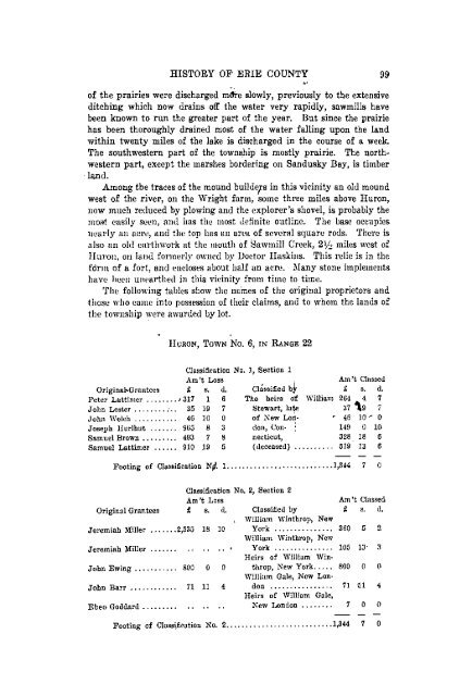
- Page 99 and 100: 74 HISTORY OF ERIE COUNTY of the go
- Page 101 and 102: 76\ HISTORY OF ERIE COUNTY He has c
- Page 103 and 104: CHAPTER VII MJLAN TOWNSHIP AND VILL
- Page 105 and 106: 80 HISTORY OF ERIE COUNTY The missi
- Page 107 and 108: 82 HISTORY OF ERIE COUNTY land, pur
- Page 109 and 110: 84 HISTORY OF ERIE COUNTY good heal
- Page 111 and 112: 86 HISTORY OF ERIE COUNTY some of B
- Page 113 and 114: 88 HISTORY OF ERIE COUNTY houses ad
- Page 115 and 116: 90 HISTORY OF ERIE COUNTY built in
- Page 117 and 118: 92 HISTORY OF ERIE COUNTY ground ov
- Page 119 and 120: 94 HISTORY OF ERIE COUNTY and his s
- Page 121 and 122: 96 HISTORY OF ERIE COUNTY The villa
- Page 123: CHAPTER VIII HURON TOAVNSHIP The To
- Page 127 and 128: 102 HISTORY OF ERIE COUNTY Jabez Wr
- Page 130 and 131: HISTORY OF ERIE COUNTY 105 lake is
- Page 132 and 133: HISTORY OF ERIE COUNTY 107 conducte
- Page 134 and 135: HISTORY OF ERIE COUNTY 109 It is sa
- Page 136 and 137: HISTORY OF ERIE COUNTY 111 were Ala
- Page 138 and 139: CHAPTER IX OXFORD TOWNSHIP Oxford i
- Page 140 and 141: HISTORY OF ERIE COUNTY 115 and saw
- Page 142 and 143: HISTORY OF ERIE COUNTY 117 apart ev
- Page 144 and 145: HISTORY OF ERIE COUNTY 119 I think
- Page 146 and 147: CHAPTER X PERKINS TOWNSHIP Perkins
- Page 148 and 149: HISTORY OF ERIE COUNTY 123 Classifi
- Page 150 and 151: HISTORY OF ERIE COUNTY 125 propriet
- Page 152 and 153: HISTORY OF ERIE COUNTY 127 is on th
- Page 154 and 155: Original Grantees Latham Avery Than
- Page 156 and 157: HISTORY OF ERIE COUNTY 131 The town
- Page 158 and 159: HISTORY OF ERIE COUNTY 133 Amos McL
- Page 160 and 161: HISTORY OF ERIE COUNTY 135 former d
- Page 162 and 163: HISTORY OF ERIE COUNTY 137 During t
- Page 164 and 165: HISTORY OF ERIE COUNTY 139 was sold
- Page 166 and 167: HISTORY OF ERIE COUNTY 141 limit. T
- Page 168 and 169: HISTORY OF ERIE COUNTY 143 a cotton
- Page 170 and 171: HISTORY OF ERIE COUNTY 145 are, A.
- Page 172 and 173: HISTORY OF ERIE COUNTY 147 J. Lossi
- Page 174 and 175:
SANDUSKY PLATTER A recent magazine
- Page 176 and 177:
HISTORY OF ERIE COUNTY 151 shirting
- Page 178 and 179:
HISTORY OF ERIE COUNTY 153 10. Log
- Page 180 and 181:
HISTORY OF ERIE COUNTY 155 of peopl
- Page 182 and 183:
HISTORY OF ERIE COUNTY 157 then imm
- Page 184 and 185:
HISTORY OF ERIE COUNTY 159 worth, K
- Page 186 and 187:
HISTORY OF ERIE COUNTY 161 for the
- Page 188 and 189:
HISTORY OF ERIE COUNTY 163 The firs
- Page 190 and 191:
HISTORY OF ERIE COUNTY 165 and wife
- Page 192 and 193:
HISTORY OF ERIE COUNTY 167 Holliste
- Page 194 and 195:
HISTORY OF ERIE COUNTY 169 the brok
- Page 196 and 197:
HISTORY OF ERIE COUNTY 171 June 1,
- Page 198 and 199:
HISTORY OF ERIE COUNTY 173 Capt. At
- Page 201 and 202:
176 HISTORY OF ERIE COUNTY POPULATI
- Page 203 and 204:
178 HISTORY OF ERIE COUNTY fortable
- Page 205 and 206:
180 HISTORY OF ERIE COUNTY Colonel
- Page 207 and 208:
182 HISTORY OF ERIE COUNTY at our t
- Page 209 and 210:
184 HISTORY OF ERIE COUNTY Among th
- Page 211 and 212:
186 HISTORY OF ERIE COUNTY ated dir
- Page 213 and 214:
188 HISTORY OF ERIE COUNTY James Bi
- Page 215 and 216:
190 HISTORY OF ERIE COUNTY Ann McGo
- Page 217 and 218:
192 HISTORY OF ERIE COUNTY T. E. Da
- Page 219 and 220:
194 HISTORY OF ERIE COUNTY in one t
- Page 221 and 222:
SANDUSKY IN 1846 CHAPTER XV SANDUSK
- Page 223 and 224:
198 HISTORY OF ERIE COUNTY cern of
- Page 225 and 226:
200 HISTORY OF ERIE COUNTY Joshua B
- Page 228 and 229:
HISTORY OF ERIE COUNTY 203 Schaub &
- Page 231 and 232:
206 HISTORY OF ERIE COUNTY then a b
- Page 233 and 234:
CEDAR POINT CHAPTER XVI SANDUSKY (C
- Page 235 and 236:
ffl o 55
- Page 237 and 238:
212 HISTORY OF ERIE COUNTY has boug
- Page 239 and 240:
X W w O 55 'Jl w" 55 W Q OQ E» W K
- Page 241 and 242:
216 HISTORY OF ERIE COUNTY 1827-28,
- Page 243 and 244:
E- 2
- Page 245 and 246:
220 HISTORY OF ERIE COUNTY 1890. It
- Page 247 and 248:
CO £> Q S w w I* w co Q K pq
- Page 249 and 250:
224 HISTORY OF ERIE COUNTY Tent No.
- Page 251 and 252:
226 HISTORY OF ERIE COUNTY With the
- Page 253 and 254:
228 HISTORY OF ERIE COUNTY The Penn
- Page 255 and 256:
230 HISTORY OF ERIE COUNTY running
- Page 257 and 258:
232 HISTORY OF BRIE COUNTY shipped
- Page 259 and 260:
CHAPTER XVIII SANDUSKY CITY SCHOOLS
- Page 261 and 262:
236 HISTORY OF ERIE COUNTY premises
- Page 263 and 264:
238 HISTORY OF ERIE COUNTY Square,
- Page 265 and 266:
240 HISTORY OF ERIE COUNTY ADOPTION
- Page 267 and 268:
242 HISTORY OF ERIE COUNTY Avas pas
- Page 269 and 270:
244 HISTORY OF ERIE COUNTY or many
- Page 271 and 272:
246 F. M. Follett E. Bill Walter F.
- Page 273 and 274:
248 HISTORY OF ERIE COUNTY Cowdery,
- Page 275 and 276:
250 HISTORY OF ERIE COUNTY seven ye
- Page 277 and 278:
252 HISTORY OF ERIE COUNTY Waddel a
- Page 279 and 280:
254 HISTORY OF ERIE COUNTY circuit,
- Page 281 and 282:
256 HISTORY OF ERIE COUNTY larger m
- Page 283 and 284:
258 HISTORY OF ERIE COUNTY Mrs. Nan
- Page 285 and 286:
260 HISTORY OF ERIE COUNTY you pick
- Page 287 and 288:
262 HISTORY OF ERIE COUNTY of Salva
- Page 289 and 290:
264 HISTORY OF ERIE COUNTY On Sunda
- Page 291 and 292:
266 HISTORY OF ERIE COUNTY gelist,
- Page 293 and 294:
268 HISTORY OF ERIE COUNTY Elder Ca
- Page 295 and 296:
270 HISTORY OF ERIE COUNTY timber,
- Page 297 and 298:
272 HISTORY OF ERIE COUNTY services
- Page 299 and 300:
274 HISTORY OF ERIE COUNTY say that
- Page 301 and 302:
276 HISTORY OF ERIE COUNTY June 15,
- Page 303 and 304:
278 HISTORY OF ERIE COUNTY measure
- Page 305 and 306:
280 HISTORY OF ERIE COUNTY however,
- Page 307 and 308:
282 HISTORY OF ERIE COUNTY and grea
- Page 309 and 310:
284 HISTORY OF ERIE COUNTY came int
- Page 311 and 312:
286 HISTORY OF ERIE COUNTY PROVIDEN
- Page 313 and 314:
By J. T. Haynes CHAPTER XXII THE OH
- Page 315 and 316:
290 HISTORY OF ERIE COUNTY extendin
- Page 317 and 318:
292 HISTORY OF ERIE COUNTY geon and
- Page 319 and 320:
CHAPTER XXIII WOMAN'S WORK THROUGH
- Page 321 and 322:
296 HISTORY OF ERIE COUNTY The thir
- Page 323 and 324:
298 HISTORY OF ERIE COUNTY and equi
- Page 325 and 326:
300 HISTORY OF ERIE COUNTY tennial
- Page 327 and 328:
302 HISTORY OF ERIE COUNTY PERSEVER
- Page 329 and 330:
304 HISTORY OF ERIE COUNTY caster,
- Page 331 and 332:
306 HISTORY OF ERIE COUNTY Garfield
- Page 333 and 334:
308 HISTORY OF ERIE COUNTY United C
- Page 335 and 336:
310 HISTORY OF ERIE COUNTY On Janua
- Page 337 and 338:
312 HISTORY OF ERIE COUNTY DENTISTR
- Page 339 and 340:
CHAPTER XXVI TEMPERANCE ACTIVITIES
- Page 341 and 342:
316 HISTORY OF ERIE COUNTY On June
- Page 343 and 344:
318 HISTORY OF ERIE COUNTY women, w
- Page 345 and 346:
320 HISTORY OF ERIE COUNTY This is
- Page 347 and 348:
322 HISTORY OF ERIE COUNTY a circul
- Page 349 and 350:
324 HISTORY OF ERIE COUNTY they hop
- Page 351 and 352:
326 HISTORY OF ERIE COUNTY was one
- Page 353 and 354:
328 HISTORY OF ERIE COUNTY The numb
- Page 355 and 356:
330 HISTORY OF ERIE COUNTY edge pre
- Page 357 and 358:
332 HISTORY OF ERIE COUNTY the men
- Page 359 and 360:
CHAPTER XXIX KELLEY'S ISLAND Kelley
- Page 361 and 362:
336 HISTORY OF ERIE COUNTY here he
- Page 363 and 364:
338 HISTORY OF ERIE COUNTY After Da
- Page 365 and 366:
340 HISTORY OF ERIE COUNTY supersed
- Page 367 and 368:
342 HISTORY OF ERIE COUNTY Norman K
- Page 369 and 370:
344 HISTORY OF ERIE COUNTY Joseph R
- Page 371 and 372:
346 HISTORY OF ERIE COUNTY AVIIO at
- Page 373 and 374:
348 HISTORY OF ERIE COUNTY returned
- Page 375 and 376:
350 HISTORY OF ERIE COUNTY about Av
- Page 377 and 378:
352 HISTORY OF ERIE COUNTY regiment
- Page 379 and 380:
354 HISTORY OF ERIE COUNTY burg, Av
- Page 381 and 382:
356 HISTORY OF ERIE COUNTY position
- Page 383 and 384:
358 HISTORY OF ERIE COUNTY of the d
- Page 385 and 386:
360 HISTORY OF ERIE COUNTY the rebe
- Page 387 and 388:
362 HISTORY OF ERIE COUNTY joined i
- Page 389 and 390:
364 HISTORY OF ERIE COUNTY the 20th
- Page 391 and 392:
366 HISTORY OF ERIE COUNTY the army
- Page 393 and 394:
368 HISTORY OF ERIE COUNTY days' sc
- Page 395 and 396:
370 HISTORY OF ERIE COUNTY its firs
- Page 397 and 398:
372 HISTORY OF ERIE COUNTY of no av
- Page 399 and 400:
374 HISTORY OF ERIE COUNTY place on
- Page 401 and 402:
376 HISTORY OF ERIE COUNTY SPANISH-
- Page 403 and 404:
378 HISTORY OF ERIE COUNTY principl
- Page 405 and 406:
380 HISTORY OF ERIE COUNTY Pleas Co
- Page 407 and 408:
382 HISTORY OF ERIE COUNTY and was
- Page 409 and 410:
384 HISTORY OF ERIE COUNTY at once
- Page 411 and 412:
386 HISTORY OF ERIE COUNTY fled wit
- Page 413 and 414:
388 HISTORY OF ERIE COUNTY and to w
- Page 415 and 416:
390 HISTORY OF ERIE COUNTY Ohio and
- Page 417 and 418:
392 HISTORY OF ERIE COUNTY man of g
- Page 419 and 420:
394 HISTORY OF ERIE COUNTY heavier
- Page 421 and 422:
396 HISTORY OF ERIE COUNTY Cincinna
- Page 423 and 424:
398 HISTORY OF ERIE COUNTY saw the
- Page 425 and 426:
400 HISTORY OF ERIE COUNTY proposit
- Page 427 and 428:
402 HISTORY OF ERIE COUNTY ing spir
- Page 429 and 430:
404 HISTORY OF ERIE COUNTY HISTORY
- Page 431 and 432:
406 HISTORY OF ERIE COUNTY prove co
- Page 433 and 434:
408 HISTORY OF ERIE COUNTY includes
- Page 435 and 436:
410 HISTORY OF ERIE COUNTY sible, t
- Page 437 and 438:
412 HISTORY OF ERIE COUNTY what Avo
- Page 439 and 440:
414 HISTORY OF ERIE COUNTY in an of
- Page 441 and 442:
THE BENCH AND BAR THE BAR OP ERIE C
- Page 443 and 444:
418 HISTORY OF ERIE COUNTY change o
- Page 445 and 446:
420 HISTORY r OF ERIE COUNTY practi
- Page 447 and 448:
422 HISTORY OF ERIE COUNTY THE ONLY
- Page 449 and 450:
424 HISTORY OF ERIE COUNTY of Avhic
- Page 451 and 452:
426 HISTORY OF ERIE COUNTY We canno
- Page 453 and 454:
428 HISTORY OF ERIE COUNTY of a gro
- Page 455 and 456:
430 HISTORY OF ERIE COUNTY throoble
- Page 457 and 458:
432 HISTORY OF ERIE COUNTY and to s
- Page 459 and 460:
434 HISTORY OF ERIE COUNTY during t
- Page 461 and 462:
436 HISTORY OF ERIE COUNTY 1868, an
- Page 463 and 464:
438 HISTORY OF ERIE COUNTY tion Avh
- Page 465 and 466:
440 HISTORY OF ERIE COUNTY has trie
- Page 467 and 468:
442 HISTORY OF ERIE COUNTY consider
- Page 469 and 470:
444 HISTORY OF ERIE COUNTY The firs
- Page 471 and 472:
446 HISTORY OF ERIE COUNTY quarries
- Page 473 and 474:
448 HISTORY OF ERIE COUNTY Delegati
- Page 475 and 476:
450 HISTORY OF ERIE COUNTY entirely
- Page 477 and 478:
452 HISTORY OF ERIE COUNTY On Decem
- Page 479 and 480:
CHAPTER XXXVII ERIE COUNTY CELEBRIT
- Page 481 and 482:
456 HISTORY OF ERIE COUNTY proud of
- Page 483 and 484:
458 HISTORY OF ERIE COUNTY that enj
- Page 485 and 486:
460 HISTORY OF ERIE COUNTY rietta (
- Page 487 and 488:
462 HISTORY OF ERIE COUNTY The Regi
- Page 489 and 490:
464 HISTORY-OF ERIE'COUNTY George I
- Page 491 and 492:
466 HISTORY OF ERIE COUNTY Then at
- Page 493 and 494:
468 HISTORY OF ERIE COUNTY he proba
- Page 495 and 496:
470 HISTORY OF ERIE COUNTY Irict sc
- Page 497:
472 HISTORY OF ERIE COUNTY of his v