- Page 1 and 2:
Quantum GIS Guida all’uso Version
- Page 3 and 4:
Copyright c○ 2004 - 2010 Quantum
- Page 5 and 6:
Indice Titolo i Preambolo ii Indice
- Page 7 and 8:
Indice 6. Lavorare con i dati raste
- Page 9 and 10:
Indice 12.11.Plugin MapServer Expor
- Page 11 and 12:
Elenco delle figure 1. Una sessione
- Page 13:
Elenco delle figure 80. OSM downloa
- Page 17 and 18:
QGIS Tips QGIS Tips 1. DOCUMENTAZIO
- Page 19 and 20:
1. Premessa Benvenuti nel meravigli
- Page 21 and 22:
• creazione e modifica di shapefi
- Page 23 and 24:
• Barra degli strumenti Editing A
- Page 25 and 26:
• Inserimento testo: Nome da most
- Page 27 and 28:
2. Introduzione al GIS Un Sistema I
- Page 29 and 30:
2.1.2. Dati vettoriali 2.1 Come mai
- Page 31 and 32:
3.3 Sessione di esempio utente, inc
- Page 33 and 34:
3.3 Sessione di esempio 5. ⊙ ’F
- Page 35 and 36:
[--extent xmin,ymin,xmax,ymax] set
- Page 37 and 38:
L’interfaccia di QGIS è divisa i
- Page 39 and 40:
4.2 Interfaccia QGIS Simplify Featu
- Page 41 and 42:
4.2 Interfaccia QGIS • Plugins -
- Page 43 and 44:
- Rimuovi - Apri tabella attributi
- Page 45 and 46:
4.2.7. Barra di stato 4.3 Visualizz
- Page 47 and 48:
4.4 Misurazioni x Per impostazione
- Page 49 and 50:
4.6 Output Il file di progetto è s
- Page 51 and 52:
4.7 Opzioni dell’interfaccia graf
- Page 53 and 54:
Figura 5: Impostazioni del proxy in
- Page 55 and 56:
5. Lavorare con i dati vettoriali Q
- Page 57 and 58:
5.1.2. Ottimizzare le prestazioni F
- Page 59 and 60:
5.2 Layer PostGIS • Fornire event
- Page 61 and 62:
5.2 Layer PostGIS QGIS richiede che
- Page 63 and 64:
5.2.5. Migliorare le prestazioni 5.
- Page 65 and 66:
5.3 Layer SpatiaLite • If everyth
- Page 67 and 68:
Simbolo singolo - lo stesso stile
- Page 69 and 70:
Understanding the new generation sy
- Page 71 and 72:
5.4 Proprietà dei layer vettoriali
- Page 73 and 74:
(a) Line composed from three simple
- Page 75 and 76:
5.4 Proprietà dei layer vettoriali
- Page 77 and 78:
5.4 Proprietà dei layer vettoriali
- Page 79 and 80:
5.4 Proprietà dei layer vettoriali
- Page 81 and 82:
Figura 18: Selezione di un elemento
- Page 83 and 84:
5.5 Modifica qualunque operazione d
- Page 85 and 86:
Abilitare la modifica topologica 5.
- Page 87 and 88:
Tip 19 MARKER DEI VERTICI La versio
- Page 89 and 90:
Modificare i vertici di un elemento
- Page 91 and 92:
5.5 Modifica gli elementi dei quali
- Page 93 and 94:
Figura 21: Finestra di creazione di
- Page 95 and 96:
5.7 Selezione mediante interrogazio
- Page 97 and 98:
6.2. Caricamento dati raster in QGI
- Page 99 and 100:
6.3.1. Scheda Simbologia QGIS può
- Page 101 and 102:
6.3 Finestra delle proprietà raste
- Page 103 and 104:
6.3.7. Scheda Istogramma 6.3 Finest
- Page 105 and 106:
7.2 Client WMS quindi consulta le s
- Page 107 and 108:
7.2 Client WMS Figura 24: Finestra
- Page 109 and 110:
• Proprietà server - Versione WM
- Page 111 and 112:
7.3.1. Caricare un layer WFS 7.3 Cl
- Page 113 and 114:
8. Lavorare con le proiezioni QGIS
- Page 115 and 116:
1. Selezionare Proprietà progetto
- Page 117 and 118:
Figura 28: Finestra del CRS persona
- Page 119 and 120:
9. Integrazione con GRASS GIS Il pl
- Page 121 and 122:
9.3 LOCATION e MAPSET in GRASS 10.
- Page 123 and 124:
9.3 LOCATION e MAPSET in GRASS Figu
- Page 125 and 126:
9.4 Importare dati nelle LOCATION G
- Page 127 and 128:
9.6. Creazione di un nuovo layer ve
- Page 129 and 130:
9.7 Digitalizzazione e modifica di
- Page 131 and 132: 9.8 Lo strumento Region di GRASS Fi
- Page 133 and 134: 9.9 La barra strumenti GRASS Come m
- Page 135 and 136: 9.9 La barra strumenti GRASS • Cl
- Page 137 and 138: Figura 39: GRASS module v.generaliz
- Page 139 and 140: 9.9 La barra strumenti GRASS Conten
- Page 141 and 142: e vettoriali di altri MAPSET. Figur
- Page 143 and 144: 10. Compositore di stampe Il compos
- Page 145 and 146: 10.1 Uso del compositore di stampe
- Page 147 and 148: 10.1.4. Creazione di file in uscita
- Page 149 and 150: 11. Plugins di QGIS Quantum GIS è
- Page 151 and 152: Figura 46: Installazione di plugin
- Page 153 and 154: 11.2. Data Providers 11.2 Data Prov
- Page 155 and 156: Tabella 6: QGIS Core Plugins Icon P
- Page 157 and 158: 12.1 Plugin di Cattura delle Coordi
- Page 159 and 160: 12.2 Plugins Decorativi Nell’esem
- Page 161 and 162: 12.3. Plugin Testo delimitato 12.3
- Page 163 and 164: 12.4. Plugin Convertitore Dxf2Shp 1
- Page 165 and 166: Understanding the Display window 12
- Page 167 and 168: 12.5 eVis Plugin • File location:
- Page 169 and 170: 12.5 eVis Plugin extension and a co
- Page 171 and 172: 12.5 eVis Plugin If a connection wa
- Page 173 and 174: Figura 57: The eVis SQL query tab 1
- Page 175 and 176: Figura 58: The eVis Perdefined quer
- Page 177 and 178: 12.5 eVis Plugin SELECT Attribute
- Page 179 and 180: Tabella 10: fTools Research tools R
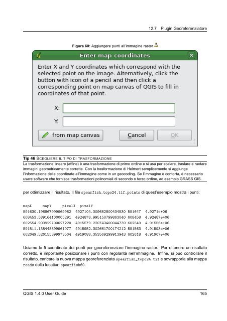
- Page 181: 12.7. Plugin Georeferenziatore 12.7
- Page 185 and 186: 12.8. Plugin GPS 12.8.1. Cos’è u
- Page 187 and 188: Figura 63: Lo strumento di download
- Page 189 and 190: 12.9. Interpolation Plugin 12.9 Int
- Page 191 and 192: 12.10. Labeling Plugin 12.10 Labeli
- Page 193 and 194: Change engine settings 12.10 Labeli
- Page 195 and 196: 12.11 Plugin MapServer Export In qu
- Page 197 and 198: 5. Introdurre 600 per la larghezza
- Page 199 and 200: 12.12. Plugin Convertitore Layer OG
- Page 201 and 202: 12.13. Oracle GeoRaster Plugin 12.1
- Page 203 and 204: Figura 74: Select Oracle GeoRaster
- Page 205 and 206: QGIS - OSM Connection Figura 75: Op
- Page 207 and 208: Figura 76: OSM plugin user interfac
- Page 209 and 210: Figura 77: Load OSM data dialog 12.
- Page 211 and 212: Point creation, 12.14 OpenStreetMap
- Page 213 and 214: 12.14.6. Editing relations 12.14 Op
- Page 215 and 216: 12.14 OpenStreetMap Plugin Replace
- Page 217 and 218: 12.14.10. Import OSM data Figura 82
- Page 219 and 220: 12.15. Raster Terrain Modelling Plu
- Page 221 and 222: 12.16. Plugin Stampa veloce 12.16 P
- Page 223 and 224: 12.17. Other core plugins 12.17 Oth
- Page 225 and 226: 14. Aiuto e Supporto 14.1. Mailingl
- Page 227 and 228: 14.4 Blog tipologia. Selezionare pa
- Page 229 and 230: A.2. Formati raster GDAL supportati
- Page 231 and 232: B. Moduli degli strumenti GRASS La
- Page 233 and 234:
B.3 Moduli negli strumenti GRASS pe
- Page 235 and 236:
B.4 Moduli negli strumenti GRASS pe
- Page 237 and 238:
B.4 Moduli negli strumenti GRASS pe
- Page 239 and 240:
B.4 Moduli negli strumenti GRASS pe
- Page 241 and 242:
B.5 Moduli negli strumenti GRASS pe
- Page 243 and 244:
B.5 Moduli negli strumenti GRASS pe
- Page 245 and 246:
B.6 Moduli negli strumenti GRASS pe
- Page 247 and 248:
B.8. Moduli negli strumenti GRASS p
- Page 249 and 250:
0. This License applies to any prog
- Page 251 and 252:
distribution of the Program. If any
- Page 253 and 254:
C.1. Quantum GIS Qt exception for G
- Page 255 and 256:
A “Secondary Section” is a name
- Page 257 and 258:
accessible at the stated location u
- Page 259 and 260:
You may combine the Document with o
- Page 261 and 262:
Each version of the License is give
- Page 263:
Letteratura citata [1] T. Mitchell.
- Page 266 and 267:
Indice analitico Keyboard shortcuts
- Page 268:
Indice analitico sistema di proiezi