Internationale Raumstation - ESA Blog Navigator
Internationale Raumstation - ESA Blog Navigator
Internationale Raumstation - ESA Blog Navigator

Erfolgreiche ePaper selbst erstellen
Machen Sie aus Ihren PDF Publikationen ein blätterbares Flipbook mit unserer einzigartigen Google optimierten e-Paper Software.
Earth Observation and Disaster Response<br />
Erdbeobachtung und Katastrophenhilfe<br />
Earth Remote Sensing from the Space Station—It’s Not Just<br />
Erdbeobachtung Handheld Cameras von Anymore der ISS aus – mehr als nur<br />
Handkamerabilder<br />
William L. Stefanov<br />
William L. Stefanov<br />
Chief Scientist, Science Applications, Research and Development Department, Jacobs5 Chief Scientist, Science Applications, Research and Development Department, Jacobs<br />
Seit die <strong>Internationale</strong> <strong>Raumstation</strong> im November 2000 in Betrieb genommen wurde, haben die Astronauten an Bord<br />
im Rahmen des Programms Crew Earth Observations über 600.000 Bilder der Landmassen und Ozeane der Erde und<br />
atmosphärischer Phänomene aufgenommen, ja sogar Bilder des Mondes von der Erdumlaufbahn aus. Für diese Fotound<br />
Filmaufnahmen verwenden sie digitale Handkameras. Trotz dieser Bilderflut und trotz ihrer offenkundigen Eignung<br />
zur Fernerkundung der Erde wird die ISS von vielen Fernerkundungsexperten nicht als Erdbeobachtungsplattform<br />
wahrgenommen. Doch dank der Installation neuer Geräte und hochmoderner Sensorsysteme an der ISS im Lauf der<br />
letzten beiden Jahre – und weiterer, in Planung begriffener Installationen – ändert sich das.<br />
5<br />
Since the International Space Station became operational in November 2000, astronauts on board<br />
have taken more than 600,000 images of the Earth’s land surface, oceans, atmospheric<br />
phenomena, and even images of the Moon from orbit using handheld film and digital cameras as<br />
part of the Crew Earth Observations experiment. Despite this large volume of imagery and clear<br />
capability for Earth remote sensing, the space station historically has not been perceived as an<br />
Earth observation platform by many remote sensing scientists. With the installation of new<br />
facilities and sophisticated sensor systems on the International Space Station over the past two<br />
years—and more to come—this perception is changing.<br />
So what can the station offer in terms of Earth remote sensing that free-flying, robotic satellite<br />
Was aber vermag die <strong>Internationale</strong> <strong>Raumstation</strong> bei der Fernerkundung der Erde zu leisten, was frei fliegende, mit<br />
systems cannot?<br />
Robotern bestückte Satellitensysteme nicht zu bieten haben?<br />
Images With a Variety of Lighting Conditions<br />
Bilder bei unterschiedlichsten Lichtverhältnissen<br />
Im Gegensatz Unlike many zu zahlreichen of the traditional herkömmlichen Earth<br />
Erdbeobachtungsplattformen observation platforms, umkreist the station die ISS<br />
die Erde orbits in einer the geneigten, Earth in an äquatorialen, inclined nicht<br />
sonnensynchronen equatorial Umlaufbahn. orbit that is not Das sun- heißt, die<br />
ISS passiert synchronous. die Erde in einem This means Winkel that zwischen the 52<br />
Grad nördlicher station und passes 52 Grad over südlicher locations Breite, on the und<br />
zwar zu Earth verschiedenen between Tages- 52 degrees und Nachtzeiten north and<br />
und bei 52 unterschiedlichen degrees south latitude Lichtverhältnissen.<br />
at<br />
Satelliten different mit Fernerkundungssensoren times of day and under zur<br />
Erdbeobachtung varying illumination wie Landsat7 conditions. oder Terra<br />
dagegen Remote befinden satellite-based sich in der Regel Earth auf einer<br />
polaren, observing sonnensynchronen sensors are Umlaufbahn. typically Sie<br />
passieren placed die gleiche on polar-orbiting, Stelle auf der Erdoberfläche<br />
sun-<br />
in Abständen synchronous von etwa platforms zwei Wochen like Landsat7 immer zu<br />
etwa der or gleichen Terra in Tageszeit. orbits designed Aufnahmen to pass unter<br />
vergleichbaren over the Lichtverhältnissen same spot on the Earth’s sind zwar<br />
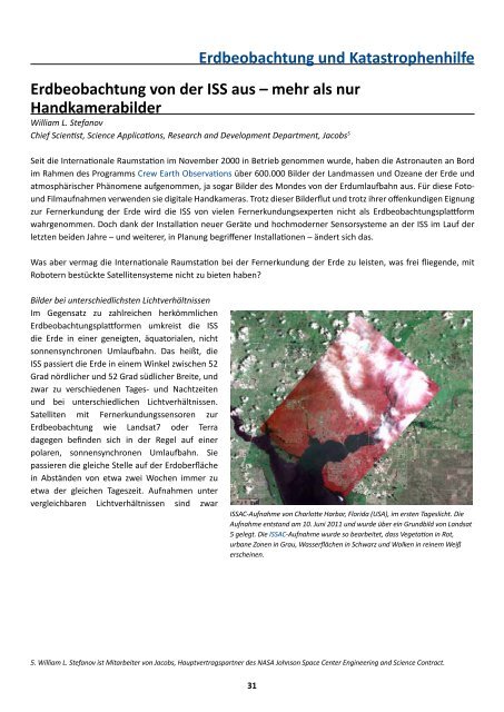
surface at approximately the same ISSAC ISSAC-Aufnahme “first light” von image Charlotte of Charlotte Harbor, Florida Harbor, (USA), Fla. im ersten acquired Tageslicht. June 10, Die<br />
time of day. These satellite<br />
2011, Aufnahme overlaid entstand on Landsat am 10. Juni 5 base 2011 und image. wurde The über ISSAC ein Grundbild scene is von Landsat<br />
processed 5 gelegt. Die to ISSAC-Aufnahme highlight vegetation wurde so in bearbeitet, red, urban dass areas Vegetation in gray, in Rot, and<br />
platforms will revisit a location<br />
water urbane surfaces Zonen in Grau, in black. Wasserflächen Clouds appear in Schwarz bright und white. Wolken in reinem Weiß<br />
erscheinen.<br />
5 William L. Stefanov is with Jacobs, the prime contractor for the NASA Johnson Space Center Engineering and Science Contract.<br />
5. William L. Stefanov ist Mitarbeiter von Jacobs, Hauptvertragspartner des NASA Johnson Space Center Engineering and Science Contract.<br />
31<br />
31