Internationale Raumstation - ESA Blog Navigator
Internationale Raumstation - ESA Blog Navigator
Internationale Raumstation - ESA Blog Navigator

Erfolgreiche ePaper selbst erstellen
Machen Sie aus Ihren PDF Publikationen ein blätterbares Flipbook mit unserer einzigartigen Google optimierten e-Paper Software.
Seit ISSAC in Betrieb ist, liefert die ISS Aufnahmen, die mit Bilddaten von Satellitensensoren auf polaren Umlaufbahnen<br />
vergleichbar With the sind. ISSAC Damit now ergänzt operational, ISSAC die data herkömmlichen collected from Erdbeobachtungsdaten the space station includes von Satelliten imagery that auf is polaren<br />
Umlaufbahnen similar to in that idealer acquired Weise, by denn polar-orbiting, das System erfasst satellite-based Bilder zu sensors. unterschiedlichen ISSAC significantly Tages- und augments Nachtzeiten the und<br />
mit unterschiedlichen traditional Earth Frequenzen. observations Dank from der polar-orbiting neuen, zum Teil satellites innen auf by der collecting WORF-Plattform, data at variable zum Teil times außen of an<br />
der ISS day installierten and with Fernerkundungssysteme, different repeat frequencies. wie zum Addition Beispiel of ISSAC, the ISSAC hat die and NASA other erheblich remote an sensing Möglichkeiten systems zur<br />
Beobachtung to the und station, Überwachung whether natürlicher housed internally und anthropogener in the WORF (menschengemachter) or mounted externally, Prozesse improves und Naturereignisse<br />
the<br />
auf der capability Erde hinzugewonnen. of NASA to observe and monitor natural and anthropogenic (of human origin) Earth<br />
processes and natural hazards.<br />
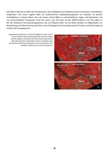
Vergleichende Aufnahmen von Minot, Norddakota, und dem Souris-<br />
Tal bei normalem<br />
Comparison<br />
Wasserstand<br />
of Minot,<br />
(oberes<br />
N.D.,<br />
Bild,<br />
and<br />
Daten<br />
Souris<br />
des Landsat<br />
River<br />
Thematic<br />
Valley<br />
Mapper)<br />
during<br />
und während<br />
normal<br />
der<br />
river<br />
Überschwemmung<br />
flow conditions<br />
(unteres<br />
(top<br />
Bild, image, ISSAC-Aufnahme). Landsat Thematic Beide Bilder Mapper wurden data) so bearbeitet, and during dass<br />
aktiv photosynthetisierende flood conditions (bottom Vegetation image, in Rot ISSAC hervorgehoben data). Both wird.<br />
images Überflutete have been urbane processed Zonen to erscheinen highlight graubraun.<br />
actively<br />
photosynthesizing vegetation in red. Urban areas<br />
appear gray-brown and water-flooded.<br />
38<br />
38