Internationale Raumstation - ESA Blog Navigator
Internationale Raumstation - ESA Blog Navigator
Internationale Raumstation - ESA Blog Navigator

Sie wollen auch ein ePaper? Erhöhen Sie die Reichweite Ihrer Titel.
YUMPU macht aus Druck-PDFs automatisch weboptimierte ePaper, die Google liebt.
Space Station Keeps Watch on World’s Sea Traffic<br />
ISS überwacht weltweiten Schiffsverkehr<br />
European Space Agency<br />
Europäische Weltraumorganisation <strong>ESA</strong><br />
As the International Space Station circles Earth, it has been tracking individual ships crossing the<br />
Lässt seas sich beneath. der Schiffsverkehr An investigation auf den Weltmeeren hosted by von the der European <strong>Internationale</strong>n Space Agency <strong>Raumstation</strong> (<strong>ESA</strong>) auf in its ihrer Columbus Umlaufbahn module Hunderte<br />
von has Kilometern been testing über der the Erde viability aus beobachten? of monitoring Seit global Juni maritime 2010 führt traffic die Europäische from the station’s Weltraumorganisation orbit hundreds <strong>ESA</strong> in<br />
ihrem of Columbus-Modul miles (kilometers) eine above entsprechende since June Machbarkeitsstudie 2010.<br />
durch.<br />
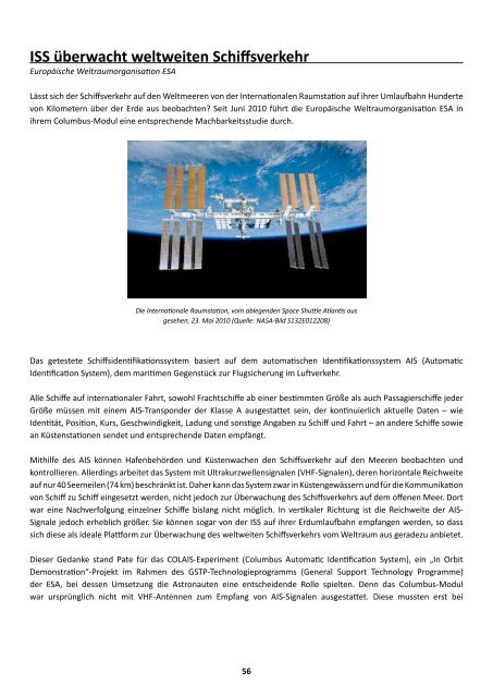
The Die International <strong>Internationale</strong> <strong>Raumstation</strong>, Space Station vom as ablegenden seen from Space the departing Shuttle Atlantis Atlantis aus<br />
gesehen, 23. space Mai 2010 shuttle, (Quelle: May NASA-Bild 23, 2010. S132E012208)<br />
(Credit: NASA image S132E012208.)<br />
The ship-detection system being tested is based on the Automatic Identification System, or AIS, the<br />
Das<br />
marine<br />
getestete<br />
equivalent<br />
Schiffsidentifikationssystem<br />
of the air traffic control<br />
basiert<br />
system.<br />
auf dem automatischen Identifikationssystem AIS (Automatic<br />
Identification System), dem maritimen Gegenstück zur Flugsicherung im Luftverkehr.<br />
All international vessels, cargo ships above certain weights and passenger carriers of all sizes must<br />
Alle<br />
carry<br />
Schiffe<br />
“Class<br />
auf internationaler<br />
A” AIS transponders,<br />
Fahrt, sowohl<br />
broadcasting<br />
Frachtschiffe<br />
continually<br />
ab einer bestimmten<br />
updated data,<br />
Größe<br />
such<br />
als<br />
as<br />
auch<br />
identity,<br />
Passagierschiffe<br />
position,<br />
jeder<br />
Größe<br />
course,<br />
müssen<br />
speed,<br />
mit einem<br />
ship particulars,<br />
AIS-Transponder<br />
cargo and<br />
der Klasse<br />
voyage<br />
A<br />
information<br />
ausgestattet<br />
to<br />
sein,<br />
and<br />
der<br />
from<br />
kontinuierlich<br />
other vessels<br />
aktuelle<br />
and shore.<br />
Daten – wie<br />
Identität, Position, Kurs, Geschwindigkeit, Ladung und sonstige Angaben zu Schiff und Fahrt – an andere Schiffe sowie<br />
an Küstenstationen<br />
AIS allows port<br />
sendet<br />
authorities<br />
und entsprechende<br />
and coast guards<br />
Daten<br />
to<br />
empfängt.<br />
track seagoing traffic, but the system relies on VHF<br />
radio signals with a horizontal range of just 40 nautical miles (74 km). This makes it useful within<br />
Mithilfe<br />
coastal<br />
des<br />
zones<br />
AIS können<br />
and on<br />
Hafenbehörden<br />
a ship-to-ship<br />
und<br />
basis,<br />
Küstenwachen<br />
but not in the<br />
den<br />
open<br />
Schiffsverkehr<br />
ocean; ocean<br />
auf<br />
traffic<br />
den Meeren<br />
was largely<br />
beobachten und<br />
kontrollieren.<br />
untracked.<br />
Allerdings<br />
However,<br />
arbeitet<br />
AIS signals<br />
das System<br />
travel<br />
mit<br />
much<br />
Ultrakurzwellensignalen<br />
further vertically,<br />
(VHF-Signalen),<br />
making the space<br />
deren<br />
station<br />
horizontale<br />
an ideal<br />
Reichweite<br />
auf nur<br />
location<br />
40 Seemeilen<br />
for space-based<br />
(74 km) beschränkt<br />
AIS signal<br />
ist.<br />
reception<br />
Daher kann<br />
and,<br />
das System<br />
therefore,<br />
zwar<br />
providing<br />
in Küstengewässern<br />
the capability<br />
und für<br />
of<br />
die<br />
tracking<br />
Kommunikation<br />
von<br />
global<br />
Schiff zu<br />
maritime<br />
Schiff eingesetzt<br />
traffic from<br />
werden,<br />
space.<br />
nicht jedoch zur Überwachung des Schiffsverkehrs auf dem offenen Meer. Dort<br />
war eine Nachverfolgung einzelner Schiffe bislang nicht möglich. In vertikaler Richtung ist die Reichweite der AIS-<br />
Signale<br />
Astronauts<br />
jedoch erheblich<br />
were instrumental<br />
größer. Sie können<br />
in enabling<br />
sogar<br />
the<br />
von<br />
COLAIS<br />
der ISS<br />
experiment,<br />
auf ihrer Erdumlaufbahn<br />
which is an<br />
empfangen<br />
in-orbit<br />
werden, so dass<br />
sich<br />
demonstration<br />
diese als ideale Plattform<br />
project of<br />
zur<br />
<strong>ESA</strong>’s<br />
Überwachung<br />
General Support<br />
des weltweiten<br />
Technology<br />
Schiffsverkehrs<br />
Program.<br />
vom<br />
Columbus<br />
Weltraum<br />
was<br />
aus<br />
not<br />
geradezu<br />
originally<br />
anbietet.<br />
outfitted with VHF antennas to capture the AIS signals; they were installed on the outside of the<br />
Dieser Gedanke stand Pate für das COLAIS-Experiment (Columbus Automatic Identification System), ein „In Orbit<br />
Demonstration“-Projekt im Rahmen des GSTP-Technologieprogramms (General Support Technology Programme)<br />
der <strong>ESA</strong>, bei dessen Umsetzung die Astronauten eine 56 entscheidende Rolle spielten. Denn das Columbus-Modul<br />
war ursprünglich nicht mit VHF-Antennen zum Empfang von AIS-Signalen ausgestattet. Diese mussten erst bei<br />
56