

Aerial Archaeology in Ireland - The Heritage Council
Aerial Archaeology in Ireland - The Heritage Council
Aerial Archaeology in Ireland - The Heritage Council

You also want an ePaper? Increase the reach of your titles
YUMPU automatically turns print PDFs into web optimized ePapers that Google loves.
1 BACKGROUND<br />
1.1 What is <strong>Aerial</strong> <strong>Archaeology</strong> and How is it Used?<br />
<strong>Aerial</strong> archaeology represents one among many methods of discover<strong>in</strong>g, <strong>in</strong>vestigat<strong>in</strong>g and dissem<strong>in</strong>at<strong>in</strong>g <strong>in</strong>formation and<br />
knowledge about physical rema<strong>in</strong>s of the past. It uses aircraft (or <strong>in</strong> some cases satellites) to provide high-level views of the<br />
historic environment and is based on conventional photography and a range of remote sens<strong>in</strong>g technologies. Not limited to<br />
any particular stage of the archaeological process, it can apply to all — from reconnaissance, measured survey, <strong>in</strong>terpretation<br />
and analysis through to publication and dissem<strong>in</strong>ation. All periods, from Neolithic to the present day, are potential subjects of<br />
<strong>in</strong>terest, as are virtually all forms of rema<strong>in</strong>s and states of survival (cropmarks, soilmarks, earthworks, structures, build<strong>in</strong>gs and<br />
landscapes, and townscapes).<br />
<strong>Aerial</strong> archaeology has numerous applications: research; monument conservation; control of development and other land-use<br />
change both at a strategic and site-specific level; and wider education and public outreach. This is becom<strong>in</strong>g better recognised<br />
across Europe (Musson and Horne 2007).<br />
Although dom<strong>in</strong>ated by photographic record<strong>in</strong>g methods, aerial archaeology is not synonymous with air photography. Other<br />
forms of remote sens<strong>in</strong>g are <strong>in</strong>creas<strong>in</strong>gly relevant, and <strong>in</strong>terpretive skills both <strong>in</strong> the air and on the ground often rely on the use<br />
of other sources of data.<br />
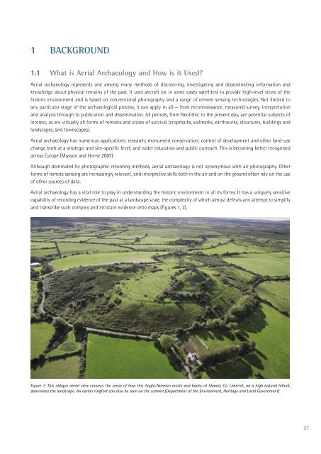
<strong>Aerial</strong> archaeology has a vital role to play <strong>in</strong> understand<strong>in</strong>g the historic environment <strong>in</strong> all its forms. It has a uniquely sensitive<br />
capability of record<strong>in</strong>g evidence of the past at a landscape scale, the complexity of which almost defeats any attempt to simplify<br />
and transcribe such complex and <strong>in</strong>tricate evidence onto maps (Figures 1, 2).<br />
Figure 1: This oblique aerial view conveys the sense of how this Anglo-Norman motte and bailey at Shanid, Co. Limerick, on a high natural hillock,<br />
dom<strong>in</strong>ates the landscape. An earlier r<strong>in</strong>gfort can also be seen on the summit (Department of the Environment, <strong>Heritage</strong> and Local Government)<br />
21


