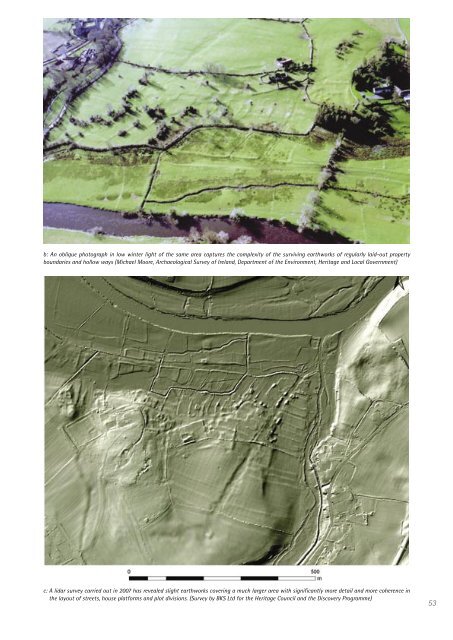
: An oblique photograph <strong>in</strong> low w<strong>in</strong>ter light of the same area captures the complexity of the surviv<strong>in</strong>g earthworks of regularly laid-out property boundaries and hollow ways (Michael Moore, Archaeological Survey of <strong>Ireland</strong>, Department of the Environment, <strong>Heritage</strong> and Local Government) c: A lidar survey carried out <strong>in</strong> 2007 has revealed slight earthworks cover<strong>in</strong>g a much larger area with significantly more detail and more coherence <strong>in</strong> the layout of streets, house platforms and plot divisions. (Survey by BKS Ltd for the <strong>Heritage</strong> <strong>Council</strong> and the Discovery Programme) 53
54 Metrical Survey As Doody observed, the simple question of ‘yield’ <strong>in</strong> terms of the number of sites identified is only part of the issue. Compared with identify<strong>in</strong>g sites, there is a big difference <strong>in</strong> the relative value of oblique and vertical photographs for accurately locat<strong>in</strong>g and survey<strong>in</strong>g them, as we have seen (Figures 26, 27). While oblique photography is better at exploit<strong>in</strong>g light<strong>in</strong>g effects to maximise clarity (Wilson 2000), vertical photography offers other advantages. It is more systematic, and offers enhanced stereoscopic view<strong>in</strong>g and greater ease <strong>in</strong> rectify<strong>in</strong>g and plott<strong>in</strong>g results (<strong>in</strong>clud<strong>in</strong>g, for example, digitally <strong>in</strong>tegrat<strong>in</strong>g scanned photographic images with terra<strong>in</strong> modell<strong>in</strong>g). It may also be noted that very high-resolution colour and panchromatic satellite imagery such as QuickBird can now produce imagery <strong>in</strong> the visible spectrum to 0.6m resolution, which is better than standard OSi ortho-photographic mapp<strong>in</strong>g (Section 3.6). Much depends on what levels of accuracy are needed. Oblique photographs are often better for identification <strong>in</strong> terms of visibility of features. <strong>The</strong>y can also be rectified to provide approximate positions on medium to large-scale maps, if that is all that is needed. But their use as a means of accurately survey<strong>in</strong>g and measur<strong>in</strong>g a monument to a high degree of accuracy (e.g. to with<strong>in</strong> a few metres) is often suspect, especially on non-flat ground. For example, rectify<strong>in</strong>g oblique aerial images to 1:10,000 or larger scale maps will result <strong>in</strong> <strong>in</strong>accurate locations for sites due to the errors <strong>in</strong> the base map itself, the change <strong>in</strong> scale throughout the image, and the errors due to relief displacement. Not all of this can be allowed for, even <strong>in</strong> bespoke rectification software, without the additional <strong>in</strong>formation provided by digital terra<strong>in</strong> models. In the past few years, the Discovery Programme has undertaken various aerial survey projects — notably at North Roscommon and Mullaghfarna, Co. Sligo — which show the considerable potential of large-format vertical photography <strong>in</strong> mapp<strong>in</strong>g archaeology (Figures 13, 32). Each of these projects was carried out us<strong>in</strong>g professional photogrammetric software. Medium and/or low-level photography were commissioned, with ground control provided by DGPS. <strong>The</strong> result<strong>in</strong>g mapp<strong>in</strong>g has produced true ortho-photos to a very high level of accuracy (each pixel cover<strong>in</strong>g 0.16m x 0.16m on the ground) that is better than base mapp<strong>in</strong>g tolerance. <strong>The</strong> new mapp<strong>in</strong>g has revealed a level of archaeological landscape and monument detail that was well beyond expectations. In the North Roscommon Project, it was found that oblique images could only be rectified to a good level of accuracy when additional control po<strong>in</strong>ts, identified from ortho-photography derived from vertical images, were used. 3.5 Lidar Pr<strong>in</strong>ciples and Strengths of Lidar This technique generates high-resolution elevation data derived from a special airborne <strong>in</strong>strument that samples the underly<strong>in</strong>g ground height us<strong>in</strong>g the return time of a laser pulse across a swathe of land (Figure 29). <strong>The</strong> data are automatically georeferenced by means of an on-board receiver l<strong>in</strong>ked to the Global Position<strong>in</strong>g System (GPS) provided by earth-orbit<strong>in</strong>g satellites. Sample po<strong>in</strong>ts are typically <strong>in</strong>terpolated at 2m horizontal <strong>in</strong>tervals, with a vertical error range of only 10-15cm which compares very favourably with conventional vertical photography. This provides a reasonably accurate means of gather<strong>in</strong>g 3-dimensional co-ord<strong>in</strong>ates of the ground surface to produce Digital Terra<strong>in</strong> Models (DTMs), though the resolution is not as good as detailed ground-level survey<strong>in</strong>g. Lidar data often conta<strong>in</strong> a degree of background noise. Vegetation, build<strong>in</strong>gs and other objects may need to be removed to detect the true land surface, and this can be achieved by filter<strong>in</strong>g and <strong>in</strong>terpolation techniques relevant to the actual application. For each po<strong>in</strong>t recorded, the lidar data provides the horizontal position of each measurement po<strong>in</strong>t at horizontal <strong>in</strong>tervals of c. 0.5m on the ground, and first return and last returns of the laser pulse and their <strong>in</strong>tensity. This allows both solid (ground) profiles to be dist<strong>in</strong>guished from vegetation and measured to with<strong>in</strong> 15cm absolute accuracy. <strong>The</strong> <strong>in</strong>tensity measurements help to establish different types of vegetation or structure.