

Aerial Archaeology in Ireland - The Heritage Council
Aerial Archaeology in Ireland - The Heritage Council
Aerial Archaeology in Ireland - The Heritage Council

Create successful ePaper yourself
Turn your PDF publications into a flip-book with our unique Google optimized e-Paper software.
70<br />
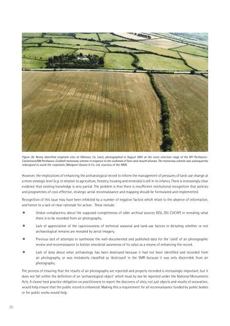
Figure 36: Newly identified cropmark sites at Oldtown, Co. Laois, photographed <strong>in</strong> August 2001 at the route selection stage of the M7 Portlaoise–<br />
Castletown/M8 Portlaoise–Cullahill motorway scheme <strong>in</strong> response to the outbreak of foot-and-mouth disease. <strong>The</strong> motorway scheme was subsequently<br />
redesigned to avoid the cropmarks (Margaret Gowen & Co. Ltd, courtesy of the NRA)<br />
However, the implications of enhanc<strong>in</strong>g the archaeological record to <strong>in</strong>form the management of pressures of land-use change at<br />
a more strategic level (e.g. <strong>in</strong> relation to agriculture, forestry, hous<strong>in</strong>g and m<strong>in</strong>erals) is still <strong>in</strong> its <strong>in</strong>fancy. <strong>The</strong>re is <strong>in</strong>creas<strong>in</strong>gly clear<br />
evidence that exist<strong>in</strong>g knowledge is very partial. <strong>The</strong> problem is that there is <strong>in</strong>sufficient <strong>in</strong>stitutional recognition that policies<br />
and programmes of cost-effective, strategic aerial reconnaissance and mapp<strong>in</strong>g should be formulated and implemented.<br />
Recognition of this issue may have been <strong>in</strong>hibited by a number of negative factors which relate to the absence of <strong>in</strong>formation,<br />
and hence to a lack of clear rationale for action. <strong>The</strong>se <strong>in</strong>clude:<br />
• Undue complacency about the supposed completeness of older archival sources (GSI, OSi CUCAP) <strong>in</strong> reveal<strong>in</strong>g what<br />
there is to be recorded from air photography.<br />
• Lack of appreciation of the capriciousness of technical seasonal and land-use factors <strong>in</strong> dictat<strong>in</strong>g whether or not<br />
archaeological rema<strong>in</strong>s are revealed by aerial imagery.<br />
• Previous lack of attempts to synthesise the well-documented and published data for the ‘yield’ of air photographic<br />
review and reconnaissance to bolster anecdotal awareness of its value as a means of enhanc<strong>in</strong>g the record.<br />
• Lack of data about what archaeology has been destroyed because it had not been identified and recorded from<br />
air photography, or was mistakenly classified as ‘destroyed’ <strong>in</strong> the SMR because it was only discernible from air<br />
photography.<br />
<strong>The</strong> process of ensur<strong>in</strong>g that the results of air photography are reported and properly recorded is <strong>in</strong>creas<strong>in</strong>gly important, but it<br />
does not fall with<strong>in</strong> the def<strong>in</strong>ition of an ‘archaeological object’ which must by law be reported under the National Monuments<br />
Acts. A clearer best practice obligation on practitioners to report the discovery of sites, not just objects and results of excavation,<br />
would help ensure that the public record is enhanced. Mak<strong>in</strong>g this a requirement for all reconnaissance funded by public bodies<br />
or for public works would help.


