An ever-<strong>in</strong>creas<strong>in</strong>g <strong>in</strong>terest <strong>in</strong> the environment and its conservation features widely <strong>in</strong> modern life, and spatial data has a special role to play <strong>in</strong> both monitor<strong>in</strong>g and manag<strong>in</strong>g environmental change. By us<strong>in</strong>g aerial or satellite imag<strong>in</strong>g, digital mapp<strong>in</strong>g or data conversion techniques, accurate locational and elevation data can be created to provide a wealth of <strong>in</strong>formation on changes <strong>in</strong> our world. BKS works both <strong>in</strong>dependently, and as part of Private F<strong>in</strong>ance Initiatives, to deliver spatial data solutions that facilitate the <strong>in</strong>tegration of a Plann<strong>in</strong>g Authority’s <strong>in</strong>formation <strong>in</strong>to an active GIS. With available technologies, BKS creates databases to hold <strong>in</strong>formation of Local Land Charges, Land Terrier, <strong>Council</strong> House Sales, Plann<strong>in</strong>g Applications, Conservation Orders etc. <strong>in</strong> a digital form, thus facilitat<strong>in</strong>g storage, retrieval, updat<strong>in</strong>g and measurement and ultimately the monitor<strong>in</strong>g of urban growth.’ 3 <strong>The</strong> size of the oblique archive collection is difficult to ascerta<strong>in</strong>, but a representative of the company reports that it may amount to c. 2,500 to 3,600 images. Vertical photography is ma<strong>in</strong>ly project-based and has recently <strong>in</strong>cluded a major resurvey of the whole of <strong>Ireland</strong> for the OSi. Other surveys <strong>in</strong>clude city-based coverage at 20-25m resolution of Dubl<strong>in</strong>, Cork, Galway, Limerick and Waterford. Vertical coverage also relates to specific types of development or land-use change (roads, hous<strong>in</strong>g, <strong>in</strong>dustry, pipel<strong>in</strong>es, forestry, and general development plann<strong>in</strong>g). Contact with archaeologists seek<strong>in</strong>g archival material is reported as be<strong>in</strong>g virtually non-existent, though certa<strong>in</strong>ly a number of photographs were commissioned or accessed dur<strong>in</strong>g the compilation of the SMR. <strong>The</strong> material is not publicly accessible for <strong>in</strong>spection, but <strong>in</strong>quiries are handled over the <strong>in</strong>ternet. Recently, the Discovery Programme and <strong>Heritage</strong> <strong>Council</strong> have commissioned BKS to undertake air photographic and lidar surveys by (see above; Figures 14 and 27). Fairey Survey and Hunt<strong>in</strong>g Surveys <strong>The</strong>se two commercial operators, lead<strong>in</strong>g exponents of vertical survey <strong>in</strong> the 1960s to 1970s, ceased to trade <strong>in</strong> the 1980s. Copies of some of their surveys (e.g. the 1971 Fairey Survey coverage of <strong>Ireland</strong>) are held <strong>in</strong> various Irish public archival collections (see above), but much of the orig<strong>in</strong>al archives were destroyed. (Aerofilms hold some Hunt<strong>in</strong>g material; Eng<strong>in</strong>eer<strong>in</strong>g Surveys hold some Fairey Survey material.) Other Companies and Internet Resources A number of other small commercial companies occasionally take archaeological air photos to order (e.g. Redmonds of Roscrea have taken photographs <strong>in</strong> the Limerick/Tipperary/Kildare area which are <strong>in</strong>cluded <strong>in</strong> the SMR files). In many cases, these were commissioned for particular requirements such as book illustrations. <strong>The</strong>y do not operate as public archives. <strong>The</strong>re are also several web-based collections, some of which conta<strong>in</strong> some aerial photographs of specific places, such as Joe Kenny’s low-level images of Fethard, Co. Tipperary, 4 5, 6 and more general collections. Another extremely valuable onl<strong>in</strong>e resource is that of Google Earth. 7 This site offers basic cover of most of the world from what appears to be Landsat TM images. Superimposed on this are blocks of much higher quality material with a resolution of 1-2m (Figure 18). 3 http://www.bks.co.uk/ 4 http://www.fethard.com/ma<strong>in</strong>pages/aerial.html 5 http://www.picturresofplaces.com/Europe/ireland.html 6 http://www.jasonhawkes.com/servlet/Public?page=search&search=ireland 7 http://maps.google.co.uk 39
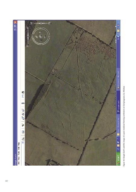
40 Figure 18: Google Earth satellite image of a post-medieval farm<strong>in</strong>g settlement at Carrignagower, Co. Wicklow