

Aerial Archaeology in Ireland - The Heritage Council
Aerial Archaeology in Ireland - The Heritage Council
Aerial Archaeology in Ireland - The Heritage Council

You also want an ePaper? Increase the reach of your titles
YUMPU automatically turns print PDFs into web optimized ePapers that Google loves.
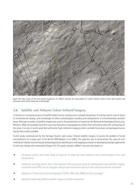
Figure 30: Lidar survey of the area around Loughcrew, Co. Meath, show<strong>in</strong>g the transcription of surface features such as relict field systems and<br />
enclosures (Col<strong>in</strong> Shell, University of Cambridge)<br />
3.6 Satellite and Airborne Colour Infrared Imagery<br />
In <strong>Ireland</strong>, an <strong>in</strong>creas<strong>in</strong>g amount of satellite-based remote sens<strong>in</strong>g work is already be<strong>in</strong>g done. It is be<strong>in</strong>g used to look at issues<br />
of environmental change, and <strong>in</strong>creas<strong>in</strong>gly for direct archaeological record<strong>in</strong>g and <strong>in</strong>terpretation <strong>in</strong> environmentally sensitive<br />
areas. Although a number of satellite images were used <strong>in</strong> the presentation of reports by the Wetland Archaeological Survey (e.g.<br />
Moloney 1993), the available resolution was more illustrative of geographical context than <strong>in</strong>formative about the archaeology of<br />
the areas. It is only <strong>in</strong> recent years that sufficiently high-resolution imag<strong>in</strong>g which is suitable for primary archaeological survey<br />
has become readily available.<br />
A pilot study commissioned by the <strong>Heritage</strong> <strong>Council</strong> used colour <strong>in</strong>frared satellite imagery to survey the problem of scrub<br />
encroachment on a major part of the Burren (ERA-Maptec et al. 2005). <strong>The</strong> objective was to demonstrate the value of such<br />
methods for habitat monitor<strong>in</strong>g and archaeological site identification and mapp<strong>in</strong>g as a basis for develop<strong>in</strong>g strategic approaches<br />
to land-use change and conservation (Figure 31). <strong>The</strong> study covered a 460km 2 area and was based on:<br />
• Literature review and desk study of sources of data for both habitats and archaeological sites and<br />
monuments.<br />
• Fieldwork cover<strong>in</strong>g seven 1km x 1km squares fully surveyed us<strong>in</strong>g air photographs and satellite images,<br />
and hand-held GPS unit to navigate and provide locational data on sites and monuments recorded.<br />
•<br />
•<br />
Analysis of historical aerial photographs (1974, 1995 and 2000 vertical coverage).<br />
Specially tasked QuickBird satellite imagery at 0.6m resolution.<br />
57


